
 United Kingdom
 France
 Germany
 Netherlands
 Sweden
 USA
USA
 Italy
Italy
 Spain
Spain
Cameras & Optics > Camera & Optic Accessories > Camera & Video Camera Lenses


Archived Product
-
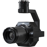
If you need any help or
advice at all on this
drone or its real world
application please give
our experts a call on
0330 041 2733 Zenmuse P1
- Efficiency through
Flexible Full-frame
Photogrammetry. The New
Benchmark for Aerial
Surveying The Zenmuse P1
integrates a full-frame
sensor with
interchangeable
fixed-focus lenses on a
3-axis stabilized gimbal.
Designed for
photogrammetry flight
missions it takes
efficiency and accuracy
to a whole new level.
Your Go-to Tool for
Aerial Photogrammetry.
Extraordinary Efficiency
The P1 includes a
full-frame low-noise
high-sensitivity sensor
that can take a photo
every 0.7 s during the
flight and covering 3 km2
[2] in a single flight.
Remarkable Accuracy
Equipped with a global
mechanical shutter and
the all-new TimeSync 2.0
system which synchronizes
time across modules at
the microsecond level the
Zenmuse P1 lets users
capture
centimeter-accurate data
combined with the
real-time position and
orientation compensation
technology. Robust
Versatility Create 2D 3D
and detailed models
thanks to the integrated
3-axis gimbal that can be
outfitted with 24/35/50mm
lenses and the Smart
Oblique Capture feature.
Efficiency to Cover It
All - Full-frame Camera.
45MP Full-frame
Sensor4.4μm Pixel
SizeLow-noise high
sensitivity imaging
extends daily operational
timeTake a photo every
0.7 s during the
flightTimeSync 2.0 aligns
the camera flight
controller RTK module and
gimbal at the microsecond
level. Flexibility to
Capture It All - Multiple
Fixed-focus Lens Options.
Global Mechanical
Shutter[3] Shutter Speed
1/2000 SecondsSends the
median exposure pulse in
microsecondsSupports
24/35/50mm lenses with
DJI DL mounts. Work Smart
Work Fast. Smart Oblique
Capture Cover 7.5 km2 [4]
in a single workday with
the P1. Elevate the
efficiency of your
oblique photography
mission using Smart
Oblique Capture where the
gimbal automatically
rotates to take photos at
the different angles
needed. Only photos
essential to the
reconstruction will be
taken at the edge of the
flight area increasing
the efficiency of post
processing by 20%[5] to
50%[6]. Smart Data
Management Your mission
data management -
streamlined. Mission
result files are
automatically associated
with the Mission Name and
Mission Time.A
centralized storage
location for photos GNSS
data and TimeStamps.MRK
files.The image metadata
contains the camera’s
intrinsic and extrinsic
parameters and the status
of RTKFieldwork Report
[7] Verify data quality
immediately post-flight
by checking the position
data and number of the
images acquired as well
as RTK status and
positioning accuracy.
Application. Topographic
MappingNatural Resource
ManagementGeological
InvestigationAEC and;
Surveying. What's in the
box?. 1 x Zenmuse P1
Payload1 x DJI DL 35mm
F2.8 LS ASPH Lens1 x 16GB
SD Card1 x Camera Body
Cap1 x Lens Rear Cap1 x
Lens Cleaning Cloth1 x
Storage Case [1] Using
Mapping Mission at a GSD
of 3 cm with an 75% front
overlap rate and a 55%
side overlap rate.[2] At
a GSD of 3 cm with an 75%
front overlap rate and a
55% side overlap rate.[3]
The global shutter is
achieved with a central
leaf shutter.[4] Using
Smart Oblique Capture at
a GSD of 3 cm with an 80%
front overlap rate and a
60% side overlap rate.[5]
Area mapped 1.5 km2
flight altitude 200 m[6]
Area mapped 0.5 km2
flight altitude 200 m[7]
Support coming soon..
Availability: In Stock
£5595.00
Archived Product
-
Yuneec E10T 320x256 50
FOV Thermal Camera for
H520
Availability: In Stock
£4548.97
Archived Product
-
Yuneec E10T 320x256 34
FOV Thermal Camera for
H520
Availability: In Stock
£4548.97
Archived Product
-
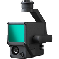
If you need any help or
advice at all on this
drone or its real world
application please give
our experts a call on
0330 041 2733 Zenmuse L1
- Instant Clarity and;
Superior Accuracy. A
Lidar + RGB Solution for
Aerial Surveying The
Zenmuse L1 integrates a
Livox Lidar module a
high-accuracy IMU and a
camera with a 1-inch CMOS
on a 3-axis stabilized
gimbal. When used with
Matrice 300 RTK and DJI
Terra the L1 forms a
complete solution that
gives you real-time 3D
data throughout the day
efficiently capturing the
details of complex
structures and delivering
highly accurate
reconstructed models.
Exceptional Efficiency
Generate true-color point
cloud models in real-time
or acquire 2 km2 of point
cloud data in a single
flight [1] using the
Livox frame Lidar module
with a 70° FOV and a
visible light camera with
a 1-inch sensor.
Unparalleled Accuracy
Render
centimeter-accurate
reconstructions thanks to
the high-accuracy IMU a
vision sensor for
positioning accuracy and
the incorporation of GNSS
data. Ready When You Are
The IP44 rating allows
the L1 to be operated in
rainy or foggy
environments. The Lidar
module’s active
scanning method enables
you to fly at night.
Visualize Data as You Fly
- Livox Lidar Module.
Frame Lidar with up to
100% effective point
cloud resultsDetection
Range 450m (80%
reflectivity 0 klx) / 190
m (10% reflectivity 100
klx)Effective Point Rate
240000 pts/sSupports 3
Returns [3]Line Scan Mode
and Non-repetitive Scan
Mode. Everything in View
- RGB Camera. 20MP1-inch
CMOSMechanical Shutter.
Accurate Details at Your
Disposal - High-accuracy
IMU. Accuracy 0.025°
(roll/pitch) / 0.08°
(yaw)Vision Sensor for
Positioning AccuracyGNSS
IMU RGB Data Fusion.
Recreate the World in 3D
Point Clouds. Point Cloud
LiveView Real-time point
clouds provide immediate
insights onsite so
operators are informed to
make critical decisions
quickly. You can also
verify fieldwork quality
by checking point cloud
data immediately after
each flight. Measurement
and Annotation Acquire
and communicate critical
dimensions on the point
cloud model using
measurements and
annotations. One-stop
Post-processing DJI Terra
fuses the IMU and GNSS
data for point cloud and
visible light
calculations in addition
to conducting POS data
calculations so you can
effortlessly generate
reconstructed models and
accuracy reports.
Application Scenarios.
Topographic
MappingEmergency
ResponseEnergy and;
InfrastructureLaw
Enforcement [1] Over 30
minutes at a speed of
10m/s a flight altitude
of 100 m with a side
overlap rate of 20% point
cloud density ); 200
points/m2.[2] Flight
altitude 50 m[3] In
operations with two or
three returns the point
rate is 480000 pts/s .
Availability: In Stock
£11600.00
Archived Product
-
E20TVX Radiometric Camera
for H520E. Top Features.
640x512 323° FOV (6.3mm
Focal Length) Thermal
Radiometric infra-red
camera and 1080P low
light RGB camera
combinable and
recordableDual video
stream can be viewed
picture-in-picture or
overlayAdjustable scene
rangeUp to 20 minutes
flight time with the
H520ESupports DataPilot
and mission planning Dual
Camera - The E20Tvx
thermal radiometric
imaging and RGB low light
camera was especially
designed for the YUNEEC
H520E. With its
multi-sensor
compatibility the E20Tvx
offers search and rescue
firefighters police and
inspectors reliable and
efficient air support.
When searching for
missing persons the drone
enables you to look for
people very quickly from
the air.In the case of a
fire hot spots can be
detected instantly
allowing fast and
efficient countermeasures
which can save lives.
When performing an
inspection all required
details can be detected
with the H520E without
having to get too close
to the object.The
drone’s live image can
be transferred to a
monitor during the flight
so several people can
take part in the
inspection and make
initial analyses during
the flight.
Specifications.
Dimensions 115 x 80 x
130mmWeight 358gStorage
Micro-SD cardField of
Vision 33°Sensitivity (;
50 mK @f/1.0Pixel size 12
μmSpectral Range 8-14
μmEffective Frame Rate
(; 25 HzPhoto format
JPEGVideo format MP4Video
resolution 640 x 512Scene
Range (High Gain) -20°C
to 150°CScene Range (Low
Gain) 100°C to 500°C..
Availability: In Stock
£4710.00
Archived Product
-
E10TX 320 34° FOV
Thermal Camera for H520E.
Top Features. FLIR®
Thermal imaging and
residual light dual
camera for H520E320x256
34° FOV (6.3mm Focal
Length) Thermal infra-red
camera and 1080P low
light RGB camera
combinable and
recordableDual video
stream can be viewed
picture-in-picture or
overlayAdjustable scene
rangeUp to 20 minutes
flight time with the
H520ESupports DataPilot
and mission planning Dual
Camera - The E10TX FLIR®
thermal imaging and RGB
low light camera was
especially designed for
the YUNEEC H520E. With
its multi-sensor
compatibility the E10TX
offers search and rescue
firefighters police and
inspectors reliable and
efficient air support.
When searching for
missing persons the drone
enables you to look for
people very quickly from
the air using the latest
Boson thermal sensor from
FLIR®.In the case of a
fire hot spots can be
detected instantly
allowing fast and
efficient countermeasures
which can save lives.
When performing an
inspection all required
details can be detected
with the H520E without
having to get too close
to the object.The
drone’s live image can
be transferred to a
monitor during the flight
so several people can
take part in the
inspection and make
initial analyses during
the flight.
Specification. Dimensions
115 x 80 x 130mmWeight
350gStorage Micro-SD
cardField of Vision
34°Thermal Focal Length
6.3mmSensitivity (; 50 mK
@f/1.0Infrared Cam
Uncooled VOx micro
bolometerPixel size 12
μmSpectral Range 8-14
μmEffective Frame Rate
(; 9 HzPhoto format JPEG
TIFFVideo format MP4Video
resolution 320 x 256Scene
Range (High Gain) 25°C
to 100°CScene Range (Low
Gain) -40°C to
550°CSpot Meter );985%
no clusters ); 3x3Image
Optimization YesDigital
Detail Enhancement
YesPolarity Control
(black hot/white hot)
YesColor and; Monochrome
Palettes (LUTs) Yes..
Availability: In Stock
£5100.00
Archived Product
-
E10TVX 640 32° FOV
Thermal camera for H520E.
Top Features. FLIR®
Thermal imaging and
residual light dual
camera for H520E640x512
32° FOV (6.3mm Focal
Length) Thermal infra-red
camera and 1080P low
light RGB camera
combinable and
recordableDual video
stream can be viewed
picture-in-picture or
overlayAdjustable scene
rangeUp to 20 minutes
flight time with the
H520ESupports DataPilot
and mission plannin Dual
Camera - The E10TVX
FLIR® thermal imaging
and RGB low light camera
was especially designed
for the YUNEEC H520E.
With its multi-sensor
compatibility the E10TVX
offers search and rescue
firefighters police and
inspectors reliable and
efficient air support.
When searching for
missing persons the drone
enables you to look for
people very quickly from
the air using the latest
Boson thermal sensor from
FLIR®.In the case of a
fire hot spots can be
detected instantly
allowing fast and
efficient countermeasures
which can save lives.
When performing an
inspection all required
details can be detected
with the H520E without
having to get too close
to the object.The
drone’s live image can
be transferred to a
monitor during the flight
so several people can
take part in the
inspection and make
initial analyses during
the flight.
Specification. Dimensions
115 x 80 x 130mmWeight
384gStorage Micro-SD
cardField of Vision
32°Thermal Focal Length
6.3mmSensitivity (; 50 mK
@f/1.0Infrared Cam
Uncooled VOx micro
bolometerPixel size 12
μmSpectral Range 8-14
μmEffective Frame Rate
(; 9 HzPhoto format JPEG
TIFFVideo format MP4Video
resolution 640 x 512Scene
Range (High Gain) 25°C
to 100°CScene Range (Low
Gain) -40°C to
550°CSpot Meter );985%
no clusters ); 3x3Image
Optimization YesDigital
Detail Enhancement
YesPolarity Control
(black hot/white hot)
YesColor and; Monochrome
Palettes (LUTs) YesSensor
1/2.8 2MP 23mm F2.8Field
of vision Diagonal
89.6°ISO range
100-12800Shutter Speed
1/30 - 1/8000 sVideo
resolution 1920 x 1080p
25 fpsPhoto format
JPEGVideo format MP4..
Availability: In Stock
£10410.00
Archived Product
-
Yuneec E10T 320x256 16
FOV Thermal Camera for
H520
Availability: In Stock
£4959.00
Archived Product
-
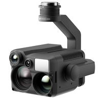
The New DJI Zenmuse H20N
for the Matrice 300! Top
Features. Starlight Night
Vision20x Hybrid Optical
ZoomIP44
RatingSynchronized
Split-screen Zoom640x512
Dual Thermal
CamerasVision Beyond
Darkness. N for Night
Vision The Zenmuse H20N
integrates starlight
sensors1 into its zoom
and wide-angle cameras.
Pair this with dual zoom
thermal cameras and a
laser rangefinder and you
have a versatile hybrid
payload that rises to the
occasion. Sensors
Upgraded Across Multiple
Dimensions. Infrared
Zoom. Dual Thermal
CamerasResolution
640×5122x Zoom
(Equivalent Focal Length
53 mm)8x Zoom (Equivalent
Focal Length 196 mm). See
the Big Picture. Night
Vision Wide
CameraStarlight Sensor
2MPStronger Low-Light
Performance. Pierce
Through the Veil. Night
Vision Zoom
CameraStarlight Sensor
4MP20× Optical Zoom
128× Max ZoomLow-Light
Details. Precise Distance
Data. Laser
RangefinderRange 3 m to
1200 mAccuracy ± (0.2 m
+ D×0.15%)2. Thermal and
Starlight Vision to
Elevate Your Operations.
See Through the Night The
zoom and wide-angle
cameras are equipped with
starlight sensors that
are tailor-made for
low-light environments.
Infrared Zoom Two thermal
cameras respectively
provide 2× and 8× zoom
together enabling up to
32× zoom. Find hotspots
and inspect in close
detail after zoom-in.
Synchronized Split-screen
Zoom H20N supports
synchronized zoom between
thermal and starlight
night vision cameras.
Users can scale both
images at the same time.
This doubles efficiency
and makes it easier to
compare details side by
side. More Intelligent
Features. PinPointSmart
TrackHigh-Res Grid
PhotoOne-tap Panorama.
Thermal Features. Color
Palettes Adjust the
colors applied to the
thermal data based on the
mission requirements.
Isotherms Visualize a
specific band of
temperatures to highlight
your targets. Temp. Alarm
Receive instant
notifications in DJI
Pilot when object
temperatures exceed your
preset alert values. Gain
Modes Adjust gain modes
to change the temperature
range captured High Gain
Mode covers a smaller
temperature range but is
more sensitive to
temperature differences;
Low Gain Mode covers a
wider temperature range.
R-JPEG Images Images
captured by the Zenmuse
H20N are in R-JPEG format
with embedded temperature
information. By importing
these images into the DJI
Thermal Analysis Tool you
can measure temperature
and adjust parameters
such as Emissivity and
Reflected Temp..
Availability: In Stock
£12720.00
Archived Product
-
Yuneec E10T 320x256 24
FOV Thermal Camera for
H520
Availability: In Stock
£4959.00
 Denmark