
 United Kingdom
 France
 Germany
 Netherlands
 Sweden
 USA
USA
 Italy
Italy
 Spain
Spain
More From Contributor
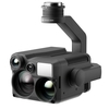
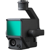


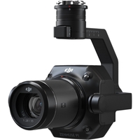
DJI Zenmuse P1 Payload For The Matrice 300 RTK
If you need any help or advice at all on this drone or its real world application please give our experts a call on 0330 041 2733 Zenmuse P1 - Efficiency through Flexible Full-frame Photogrammetry. The New Benchmark for Aerial Surveying The Zenmuse P1 integrates a full-frame sensor with interchangeable fixed-focus lenses on a 3-axis stabilized gimbal. Designed for photogrammetry flight missions it takes efficiency and accuracy to a whole new level. Your Go-to Tool for Aerial Photogrammetry. Extraordinary Efficiency The P1 includes a full-frame low-noise high-sensitivity sensor that can take a photo every 0.7 s during the flight and covering 3 km2 [2] in a single flight. Remarkable Accuracy Equipped with a global mechanical shutter and the all-new TimeSync 2.0 system which synchronizes time
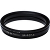
across modules at the microsecond level the Zenmuse P1 lets users capture centimeter-accurate data combined with the real-time position and orientation compensation technology. Robust Versatility Create 2D 3D and detailed models thanks to the integrated 3-axis gimbal that can be outfitted with 24/35/50mm lenses and the Smart Oblique Capture feature. Efficiency to Cover It All - Full-frame Camera. 45MP Full-frame Sensor4.4μm Pixel SizeLow-noise high sensitivity imaging extends daily operational timeTake a photo every 0.7 s during the flightTimeSync 2.0 aligns the camera flight controller RTK module and gimbal at the microsecond level. Flexibility to Capture It All - Multiple Fixed-focus Lens Options. Global Mechanical Shutter[3] Shutter Speed 1/2000 SecondsSends the median exposure pulse
in microsecondsSupports 24/35/50mm lenses with DJI DL mounts. Work Smart Work Fast. Smart Oblique Capture Cover 7.5 km2 [4] in a single workday with the P1. Elevate the efficiency of your oblique photography mission using Smart Oblique Capture where the gimbal automatically rotates to take photos at the different angles needed. Only photos essential to the reconstruction will be taken at the edge of the flight area increasing the efficiency of post processing by 20%[5] to 50%[6]. Smart Data Management Your mission data management - streamlined. Mission result files are automatically associated with the Mission Name and Mission Time.A centralized storage location for photos GNSS data and TimeStamps.MRK files.The image metadata contains the camera’s intrinsic and extrinsic parameters and
the status of RTKFieldwork Report [7] Verify data quality immediately post-flight by checking the position data and number of the images acquired as well as RTK status and positioning accuracy. Application. Topographic MappingNatural Resource ManagementGeological InvestigationAEC and; Surveying. What's in the box?. 1 x Zenmuse P1 Payload1 x DJI DL 35mm F2.8 LS ASPH Lens1 x 16GB SD Card1 x Camera Body Cap1 x Lens Rear Cap1 x Lens Cleaning Cloth1 x Storage Case [1] Using Mapping Mission at a GSD of 3 cm with an 75% front overlap rate and a 55% side overlap rate.[2] At a GSD of 3 cm with an 75% front overlap rate and a 55% side overlap rate.[3] The global shutter is achieved with a central leaf shutter.[4] Using Smart Oblique Capture at a GSD of 3 cm with an 80% front overlap rate and a 60%
side overlap rate.[5] Area mapped 1.5 km2 flight altitude 200 m[6] Area mapped 0.5 km2 flight altitude 200 m[7] Support coming soon..

 Denmark