More From Contributor

£6.99
Alabama Easy-to-Read map from Rand Mc Nally, US leading publisher of road maps & street plans, in their extensive series of state maps. Additional panels provide enlargements for Birmingham, Auburn
- Opelika, Montgomery, Florence, Huntsville, Phoenix City
- Columbus, GA, Tuscaloosa, Mobile & Dotham. For clarity of road information Rand Mc Nally state maps present the road network on a plain background, with no or little topographic detail. Driving distances are indicated on all principal highways & on many local routes. National or state parks & other protected areas, Indian Reservations & restricted entry military zones are highlighted & symbols indicate campsites, rest areas, various places of interest, etc. Each map shows local administrative boundaries with names of the counties, is indexed & gives geographical coordinates as margin ticks usually at 1° intervals. Rand Mc Nally state maps are available in two formats: double-sided Easy-to-Read maps with numerous enlargements for cities and/or most visited areas, & laminated Easy-to-Fold maps in a more handy format but with smaller print. TO SEE THE LIST OF RAND Mc NALLY STATE MAPS PLEASE CLICK ON THE SERIES LINK.

...
Archived Product
£11.95
Alabama Off the Beaten Path features the things travelers & locals want to see & experience--if only they knew about them. From the best in local dining to quirky cultural tidbits to hidden attractions, unique finds, & unusual locales, Alabama Off the Beaten Path takes the reader down the road less traveled & reveals a side of Alabama that other guidebooks just don`t offer. In addition to the text being fully revised & updated, the 10th edition features a new cover treatment & new series branding. ...
Archived Product
£19.99
Alabama Recreational Atlas & Gazetteer at 1:182, 000 approx. in a series of large format paperback state atlases from De Lorme, with detailed, contoured, GPS compatible topographic mapping. Recreational information in this title

Includes::
lists of whitewater rivers & streams, fresh water fishing & hunting areas (indicating species), salt water fishing access, hiking trails, campgrounds, golf courses, historical sites, covered bridges, etc. Each title in this De Lorme series covers one state & presents it at a scale much more detailed than used on most state road maps. Particularly popular areas are often also presented on enlargements. The maps are contoured, show variation of terrain (deserts, glaciers, wetlands, woodlands, etc) & have latitude & longitude and/or UTM grid lines for GPS use. Various types of protected areas are distinguished by the colouring of their boundaries, e.g. national or state parks, forests, etc. Also marked are Indian Reservations & restricted entry military zones. Road network is shown in much more detail than on other state mapping, with local roads, unsurfaced back roads & tracks, forest trails, etc. Where appropriate, old historical routes are marked. Railway lines & local airports or landing strips are included & the maps also indicate administrative boundaries. Symbols highlight various recreational areas & facilities such as campgrounds, unique natural features, etc. Each title contains extensive lists of outdoor adventure sites (grouped into activities such as hiking, biking, paddling, fishing, skiing, etc.), diverse family outing sites, campgrounds, & tables showing what facilities can be found in the state’s recreational areas. Each atlas also has an index of localities. To see the list of titles in this series please click on the series link.

...
Archived Product
£30.00
Detailed physical wall map of Alabama State at a scale of 1:500, 000. The cartography shows relief through a stunning, highly ...
Archived Product
£17.99
The 1:50 000 topographic map gives a more general picture of the ground features than a basic map. It shows settlements, houses, roads, cultivated areas, waterways, cutting areas, mires, rock exposures, & relief. One map sheet covers an area of 30 x 40 km & one centimetre corresponds to 500 metres on the ground. The 1:50, 000 topographic map is also an ideal complement to nautical charts as it provides useful information about the land areas adjacent to waterways. For example, all Finnish sea areas are covered by 1:50 000 topographic map sheets. ...
Archived Product
£6.50
Topographic coverage of the Balearic Islands at 1:25, 000 published by the Instituto Geográfico Nacional – Centro Nacional de Información Geografica, the country’s civilian survey organization. The maps have contours at 10m intervals & colouring and/or graphics to show different types of vegetation or land use. Boundaries of national parks & other protected areas are marked. In addition to all the usual information shown on topographic mapping at this scale: detailed presentation of the road & rail networks, rural tracks & paths, etc, the maps also show campsites. The maps have a 1-km UTM grid, plus margin ticks for latitude & longitude at 1` intervals. The majority of the titles have been published since late 1990s. Map legend is in Spanish only. COVERAGE: each 25K map covers one quarter of the corresponding 1:50, 000 map, with the numbering system: I = NW quarter, II = NE quarter, III = SW quarter, & IV = SE quarter. To see other titles in this ser 25K Spain CNIG Topographic Survey Map No. ies please click on the series link. ...
Archived Product
£6.95
Topographic coverage of the Balearic Islands at 1:50, 000 in the MTN50 (Mapa Topográfico Nacional) series from the Instituto Geográfico Nacional – Centro Nacional de Información Geografica, the country’s civilian survey organization. The maps have contours at 20m intervals, enhanced by relief shading, plus colouring and/or graphics to show different types of terrain, vegetation or land use. Boundaries of national parks & other protected areas are marked. In addition to all the usual information featured on topographic mapping at this scale: detailed presentation of the road & rail networks, rural tracks & paths, etc, the maps also show campsites & mountain refuges. On more recent editions some GRs, the official long-distance hiking routes, are also marked (although not as clearly as on hiking maps from other publishers). The MTN50 series was begun in late 1990s. Each map covers 28.5x 18.5 km (with adjustments in the coastal areas). The maps have a 1-km UTM grid, plus margin ticks for latitude & longitude at 1` intervals. Map legend is in Spanish only. To see other titles in this series please click on the series link. ...
Archived Product
£17.99
The 1:50, 000 topographic map gives a more general picture of the ground features than a basic map. It shows settlements, houses, roads, cultivated areas, waterways, cutting areas, mires, rock exposures, & relief. One map sheet covers an area of 30 x 40 km & one centimetre corresponds to 500 metres on the ground. The 1:50, 000 topographic map is also an ideal complement to nautical charts as it provides useful information about the land areas adjacent to waterways. For example, all Finnish sea areas are covered by 1:50, 000 topographic map sheets. ...
Archived Product
£6.95
Topographic coverage of mainland Spain at 1:50, 000 in the MTN50 (Mapa Topográfico Nacional) series from the Centro Nacional de Información Geografica, the country’s civilian survey organization. The maps have contours at 20m intervals, enhanced by relief shading, plus colouring and/or graphics to show different types of terrain, vegetation or land use. Boundaries of national parks & other protected areas are marked. In addition to all the usual information featured on topographic mapping at this scale, detailed presentation of the road & rail networks, rural tracks & paths, etc, the maps also show campsites & mountain refuges. On more recent editions some GRs, the official long-distance hiking routes, are also marked (although not as clearly as on hiking maps from other publishers). Each map covers 29.5x 18.5 km (with adjustments in the border or coastal areas). The maps have a 1-km UTM grid, plus margin ticks for latitude & longitude at 1` intervals. Map legend is in Spanish only.HOW TO CHOOSE THE RIGHT 50K MAP: all the titles in CNIG’s 200K Provincial Road Maps series at 1:200, 000 are overprinted with the grid for the 1:50, 000 maps & can be used to see the area covered by each 50K title. TO SEE THE LIST OF TITLES IN THIS SERIES PLEASE CLICK ON THE SERIES LINK.PLEASE NOTE
- MAP TITLES: the grids shown on our website serve both the civilian & the military 1:50, 000 topographic series. Although the areas covered by maps in both series are identical (apart from some border or coastal sheets), occasionally map titles differ – only one title is shown on the grid, usually the military one. In Galicia, the Basque country & in the Catalan speaking areas the tendency now is to use local place names rather than the often better known Castilian ones. Where possible, both versions are included in our titles. Map titles listed on our website are based on information received by us at the time of publication, but sometimes maps arrive showing a completely different title! As long as the map number is as ordered, the correct map has been supplied.
...
Archived Product
£6.50
Topographic coverage of mainland Spain at 1:25, 000 published by the Centro Nacional de Información Geograficá, the country’s civilian survey organization. The maps have contours at 10m intervals & colouring and/or graphics to show different types of vegetation or land use. Boundaries of national parks & other protected areas are marked. In addition to all the usual information shown on topographic maps at this scale, detailed presentation of the road & rail networks, rural tracks & paths, etc, the maps also show campsites. The maps have a 1-km UTM grid, with margin ticks for latitude & longitude at 1` intervals. Map legend is in Spanish only.PLEASE NOTE: our grid for the whole of Spain is in preparation
- in the meantime, for areas other than those shown on the attached grid please use CNIG’s topographic survey at 1:50, 000 by searching for ‘SI00000832’. Each 25K map covers one quarter of the corresponding 50K map, with the numbering system: I = NW quarter, II = NE quarter, III = SW quarter & IV = SE quarter. CNIG maps in the Provincial Road Maps series at 1:200, 000 are overprinted with the grid for the 1:50, 000 survey & can be used to see the area covered by each 50K or 25K title in more detail. To see the list of titles in this series please click on the series grid
- for map numbers not yet listed on our website please contact us by email.

...
Archived Product

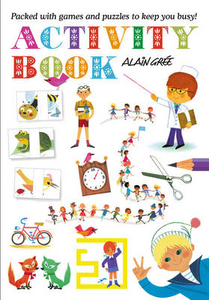
Alain Gree - Activity Book: Packed With Games And Puzzles To Keep You
Busy!

Packed with over 50 activities compiled by Alain Gree himself using a huge number of his illustrations created over the years, the Alain Gree Activity Book will keep a child busy for hours on end (and some adults too!). The activities include spot the difference, matching games and mazes as well as activities involving cutting out, folding and creating objects such as an old style television with a scrolling image and building a paper house. All of the pages are incredibly absorbing with Alain`s unmistakably rich style of illustration. Each page of the activity book is printed single sided and also glued rather than stitched allowing the pages to be removed and displayed. Certain activities will appeal more to younger children (3+) while other will appeal to slightly older children.
RIP - This product is no longer available on our network. It was last seen on 25.09.2019

This page now acts as a permanent archive for this product. Add more information using the comments box below to ensure it can still be found by future generations.

Use our search facility to see if it is available from an alternative contributor.
  • Availability: Out Of Stock
  • Supplier: Stanfords
  • SKU: 9781908985576
Availability: In Stock
£9.99

Product Description

Packed with over 50 activities compiled by Alain Gree himself using a huge number of his illustrations created over the years, the Alain Gree Activity Book will keep a child busy for hours on end (and some adults too!). The activities include spot the difference, matching games & mazes as well as activities involving cutting out, folding & creating objects such as an old style television with a scrolling image & building a paper house. All of the pages are incredibly absorbing with Alain`s unmistakably rich style of illustration. Each page of the activity book is printed single sided & also glued rather than stitched allowing the pages to be removed & displayed. Certain activities will appeal more to younger children (3+) while other will appeal to slightly older children.

Reviews/Comments

Add New

Intelligent Comparison

Oooops!
We couldn't find anything!
Perhaps this product's unique.... Or perhaps we are still looking for comparisons!
Click to bump this page and we'll hurry up.

Price History

Vouchers

No voucher codes found.
Do you know a voucher code for this product or supplier? Add it to Insights for others to use.

Facebook

Jargon Buster

Paper - A thin sheet mainly used for writing. Available in a variety of colours. Made mainly from wood pulp.
Television - A device used for receiving moving images and sound
cutting - The seperation of an object usually using a cutting tool such as a knife
illustrations - Pictures typically in books and newspapers.
Children - A young life form within the early stages of physical development,

Supplier Information

Stanfords
Stanfords was established in 1853 and opened their iconic Covent Garden flagship store in 1901. They have become the top retailer of maps, travel books and accessories in the UK and arguably offer the largest selection of maps and travel books worldwide. Famous names such as Captain Robert Falcon Scott, Ranulph Fiennes and Michael Palin have purchased from Stanfords. They now have a shop in Bristol and both stores together with other venues operate a calendar of events including talks, book signings and exhibitions. As a specialist map retailer, the map selection is comprehensive and includes road maps, street maps and walking maps from worldwide destinations, as well as a selection of world atlases and wall maps. Books include travel guides and travel literature. Stanfords also stock globes, from miniatures made of blue marble to magnificent floor-standing globes. The website features a selection of interesting articles on travel topics.
Page Updated: 2023-11-12 20:15:36

Community Generated Product Tags

Oh No! The productWIKI community hasn't generated any tags for this product yet!
Menu