More From Contributor

£6.50
Topographic coverage of mainland Spain at 1:25, 000 published by the Centro Nacional de Información Geograficá, the country’s civilian survey organization. The maps have contours at 10m intervals & colouring and/or graphics to show different types of vegetation or land use. Boundaries of national parks & other protected areas are marked. In addition to all the usual information shown on topographic maps at this scale, detailed presentation of the road & rail networks, rural tracks & paths, etc, the maps also show campsites. The maps have a 1-km UTM grid, with margin ticks for latitude & longitude at 1` intervals. Map legend is in Spanish only.PLEASE NOTE: our grid for the whole of Spain is in preparation
- in the meantime, for areas other than those shown on the attached grid please use CNIG’s topographic survey at 1:50, 000 by searching for ‘SI00000832’. Each 25K map covers one quarter of the corresponding 50K map, with the numbering system: I = NW quarter, II = NE quarter, III = SW quarter & IV = SE quarter. CNIG maps in the Provincial Road Maps series at 1:200, 000 are overprinted with the grid for the 1:50, 000 survey & can be used to see the area covered by each 50K or 25K title in more detail. To see the list of titles in this series please click on the series grid
- for map numbers not yet listed on our website please contact us by email.

...
Archived Product
£20.00
Alan dons his boots, windcheater & scarf & embarks on an odyssey through a place he once knew
- it`s called Britain
- intent

...
Archived Product
£7.99
In ALAN PARTRIDGE: NOMAD, Alan dons his boots, windcheater & scarf & embarks on an odyssey through a place he once knew
- it`s
...
Archived Product
£12.99
Alan Stoob, hero of this hilarious novel has been described as a new member of the great pantheon of British comic characters
-
...
Archived Product
£7.99
One of the most exciting aspects of gardening is growing your own plants from scratch. In this definitive guide, Alan Titchmarsh shows how simple it is to propagate plants by following a few basic techniques. Learn how to produce a flourishing garden filled with ornamental & edible plants, at very little expense.

Features:
demystified, down-to-earth approach to propagation; easy-to-follow instructions & step-by-step diagrams; A-Z directory with recommended propagation techniques for each plant; key tips on taking cuttings, sowing seed, layering & division; & guidance on promoting growth of young plants.

...
Archived Product
£18.99
Åland (Ahvenanmaa) & the neighbouring islands off the south-west coast of Finland on a detailed touring & recreational map at 1:150, 000 from the Finnish national survey organization Karttakeskus, with a street plan of Mariehamn (Maarianhamina). Road information

Includes::
what is confusingly described in the map legend as “private” roads; these are unsurfaced roads, open to the general public but simply privately maintained. An overprint for cycle routes indicates surfaced & unsurfaced routes, & local nature trails are marked. A wide range of symbols indicates different types of tourist accommodation including campsites & youth hostels, museums, sport & recreational facilities, local shops & petrol stations, etc. The map also shows ferry connections between the islands & with the mainl&. The map has a UTM grid plus latitude & longitude lines. Map legend

Includes::
English. Also provided is a plan of Mariehamn (Maarianhamina) indicating cycling routes across the town.


...
Archived Product
£9.95
Allan Huglstad’s Alanya & Beyond guidebook explores the Turkish coastline between Antalya & Anamur, taking in some of the coast’s most historic towns & settlements. The guide is mainly targeted at those wanting to explore the coast by car, but is also suitable for walkers as it takes in all of the main sites & attractions within a half or day’s drive from Alanya. Focussing on the region’s historical building, myths & landscape, the author profiles the area in considerable depth. The main part of the guide is divided between East & West of Alanya & also a comprehensive guide to the towns of Alanya & Antalya. There is also a short chapter with recommendation for a day trip to Turkish Cyprus. There is also a dedicated chapter to Driving in Turkey, with advice & information on traffic culture, rules, road signs, road accidents & assistance, police checkpoints, car papers, car rental & useful Turkish words & phrases. A general Vocabulary section is also provided. ...
Archived Product
£6.95
Alanya Tourist Plan from Mepmedya at 1:9, 000 is a detailed street plan of the city. Shows main streets, urban transport & many places of interest.

Includes::
a plan of Alanya Castle & a road map of the surrounding area. * Map legend in English & Turkish.* Major & secondary roads & main streets are named or numbered. The tramway service is displayed & local bus stations are marked. Local districts are named & demarcated, & many places of interest are annotated on the map. These include: hotels, shops & museums; places of worship, public buildings, post offices, schools & emergency services; & parks, beaches, Turkish baths & sports & entertainment venues. The most important sites are numbered, with descriptions & photography appearing on the reverse of the map. Also
Includes::* An inset showing a plan of Alanya Castle (scale not shown).* A road map overview of the Alanya area at 1:325, 000, showing places of interest, relief shading & spot heights.


...
Archived Product
£6.50
Topographic coverage of the Balearic Islands at 1:25, 000 published by the Instituto Geográfico Nacional – Centro Nacional de Información Geografica, the country’s civilian survey organization. The maps have contours at 10m intervals & colouring and/or graphics to show different types of vegetation or land use. Boundaries of national parks & other protected areas are marked. In addition to all the usual information shown on topographic mapping at this scale: detailed presentation of the road & rail networks, rural tracks & paths, etc, the maps also show campsites. The maps have a 1-km UTM grid, plus margin ticks for latitude & longitude at 1` intervals. The majority of the titles have been published since late 1990s. Map legend is in Spanish only.COVERAGE: each 25K map covers one quarter of the corresponding 1:50, 000 map, with the numbering system: I = NW quarter, II = NE quarter, III = SW quarter, & IV = SE quarter. To see other titles in this series please click on the series link. ...
Archived Product
£11.95
Alaska, including the Aleutian Islands, at 1:3, 000, 000 on an exceptionally detailed map published by Imus Geographics with an extensive index listing both towns or small settlements & geographical features such as peaks, glaciers, rivers, bays & islands, etc. The map provides an uninterrupted view of the whole state, without any peripheral regions or islands tucked away in insets. Shading & latitude colouring are used to show the general relief, with names and/or spot heights for many peaks. More rivers or lakes are shown & named than on other similar scale maps of the state. Boundaries of national or state parks, forest & other protected areas are highlighted. Also marked are Indian reservations, the National Petroleum Reserve & internal administrative boundaries. With the wealth of topographic information in the background, road network is inevitably less clearly visible than on purely road maps, but is presented distinguishing between paved highways (shown with driving distances), gravel highways & other roads. Railways lines aand coastal ferry routes included & airports are graded into those with scheduled jet services, public access or military airports & seaplane bases. Also marked are the Iditarod Trail & the course of the Trans-Alaska pipeline. Symbols indicate state parks with camping facilities, visitor centres, marine parks & wildlife watching sites, ski areas, etc. Latitude & longitude lines are drawn at 2 ...
Archived Product

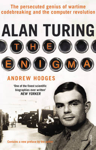
Alan Turing: The Enigma

A new edition to celebrate Alan Turing`s centenary, includes a new foreword by the author and a preface by Douglas Hofstadter. Alan Turing was the extraordinary Cambridge mathematician who masterminded the cracking of the German Enigma ciphers and transformed the Second World War. But his vision went far beyond this crucial achievement. Before the war he had formulated the concept of the universal machine, and in 1945 he turned this into the first design for a digital computer. Turing`s far-sighted plans for the digital era forged ahead into a vision for Artificial Intelligence. However, in 1952 his homosexuality rendered him a criminal and he was subjected to humiliating treatment. In 1954, aged 41, Alan Turing committed suicide and one of Britain`s greatest scientific minds was
lost.
RIP - This product is no longer available on our network. It was last seen on 25.09.2019

This page now acts as a permanent archive for this product. Add more information using the comments box below to ensure it can still be found by future generations.

Use our search facility to see if it is available from an alternative contributor.
  • Availability: Out Of Stock
  • Supplier: Stanfords
  • SKU: 9780099116417
Availability: In Stock
£10.99

Product Description

A new edition to celebrate Alan Turing`s centenary,

Includes::
a new foreword by the author & a preface by Douglas Hofstadter. Alan Turing was the extraordinary Cambridge mathematician who masterminded the cracking of the German Enigma ciphers & transformed the Second World War. But his vision went far beyond this crucial achievement. Before the war he had formulated the concept of the universal machine, & in 1945 he turned this into the first design for a digital computer. Turing`s far-sighted plans for the digital era forged ahead into a vision for Artificial Intelligence. However, in 1952 his homosexuality rendered him a criminal & he was subjected to humiliating treatment. In 1954, aged 41, Alan Turing committed suicide & one of Britain`s greatest scientific minds was lost.

Reviews/Comments

Add New

Intelligent Comparison

Oooops!
We couldn't find anything!
Perhaps this product's unique.... Or perhaps we are still looking for comparisons!
Click to bump this page and we'll hurry up.

Price History

Vouchers

No voucher codes found.
Do you know a voucher code for this product or supplier? Add it to Insights for others to use.

Facebook

Jargon Buster

Computer - A programmable electronic machine which stores and manipulates data.
Digital - A system that uses only 0s and 1s to transmit data
World - A physical grouping, commonly used to describe earth and everything associated with ti
Treatment - A way in which medics care for patients illnesses. A manner which someone behaves to someone else.
Design - A drawing or styles that shows the look and functionality of something before its made.
Vision - To be able to imagine, also can mean what you can see.

Supplier Information

Stanfords
Stanfords was established in 1853 and opened their iconic Covent Garden flagship store in 1901. They have become the top retailer of maps, travel books and accessories in the UK and arguably offer the largest selection of maps and travel books worldwide. Famous names such as Captain Robert Falcon Scott, Ranulph Fiennes and Michael Palin have purchased from Stanfords. They now have a shop in Bristol and both stores together with other venues operate a calendar of events including talks, book signings and exhibitions. As a specialist map retailer, the map selection is comprehensive and includes road maps, street maps and walking maps from worldwide destinations, as well as a selection of world atlases and wall maps. Books include travel guides and travel literature. Stanfords also stock globes, from miniatures made of blue marble to magnificent floor-standing globes. The website features a selection of interesting articles on travel topics.
Page Updated: 2023-11-12 20:15:36

Community Generated Product Tags

Oh No! The productWIKI community hasn't generated any tags for this product yet!
Menu