More From Contributor
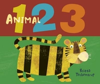
£28.61
Colloquial Amharic is the essential guide to learning this beautiful language. Specially written by an experienced teacher for self-study or class use, the course offers you a step-by-step approach to written & spoken Amharic. No prior knowledge of the language is required.
Colloquial Amharic is:
interactive
- with lots of exercises for regular practice
clear
- with concise grammar notes
practical
- with useful vocabulary & pronunciation guide
complete
-

Includes::
answer key & special reference section.
Two 60 minute cassettes are also available to help you with listening & pronunciation skills.


...
Archived Product
£11.99
A monumental literary event: the newly discovered final novel by seminal Harlem Renaissance writer Claude Mc Kay, a rich & multilayered portrayal of life in 1930s Harlem & a historical protest for black freedom This colourful, dramatic novel centres on the efforts by Harlem intelligentsia to organize support for the liberation of fascist-controlled Ethiopia, a crucial but largely forgotten event in American history. At once a penetrating satire of political machinations in Depression-era Harlem & a far-reaching story of global intrigue & romance, Amiable with Big Teeth plunges into the concerns, anxieties, hopes & dreams of African-Americans at a moment of crisis for the soul of Harlem
- & America.
...
Archived Product
£6.99
Street plan of Amiens at 1:13, 000 with an enlargement showing the town centre in greater detail, plus a road map of the city’s environs. This title is part of an extensive series of street plans of French towns from Blay-Foldex, the country’s largest, oldest & most experienced publisher of urban mapping. Blay plans include outer suburbs &, where appropriate, adjoining localities forming part of the urban agglomeration & provide brief descriptions of the town’s main sights, contact details for hotels & other places of interest, etc. The plans show one way streets, car parks & pedestrian zones. Important public buildings are clearly marked & identified. Blay street maps are usually double-sided & include an enlargement for the town centre & a street index with separate lists of “edifices publics”: main public buildings, places of worship, schools, sport facilities, stations, etc. Each of the outer suburbs or the adjoining localities, identified with its postcode, has a separate index. Many titles also provide a road map of the environs. All the text is in French only.PLEASE NOTE: to see the list of Blay-Foldex street plans of French towns & cities please click on the series link – the series description also

Includes::
a comparison between Blay & IGN street plans.

...
Archived Product
£11.50
Topographic survey of France at 1:25, 000 in IGN`s excellent TOP25 / Série Bleue series. All the maps are GPS compatible, with a 1km UTM grid plus latitude & longitude lines at 5’ intervals. Contours are at 5m intervals except for mountainous areas where the maps have contours at 10m intervals, vividly enhanced by hill shading & graphics for rocky terrain. Colouring with graphics indicates different types of vegetation or land use (deciduous or coniferous forests, moors, orchards, vineyards, etc). PLEASE NOTE: coverage of France at this scale is currently being revised – the format & the presentation of each title are indicated by the letters at the end of its Sheet Reference number (e.g. 0416ET, 3531ETR, 1923SB, etc.)MAPS WITH FULL TOURIST OVERPRINT & AN ENGLISH MAP LEGEND: all TOP25 maps & the SB editions of Série Bleue have an overprint highlighting waymarked walking trails including long-distance GR routes &, where appropriate, ski routes. Symbols indicate campsites, gîtes d’etape, refuges, equestrian centres & other recreational facilities or sites, tourist information centres, cultural heritage, etc. Towns & locations of particular interest are highlighted.- ET or OT = single-sided TOP25 map covering approx. 29x 21 km / 18x 13 miles.- ETR or OTR = waterproof & tear resistant TOP25 map covering the same area as the corresponding ET or OT number, but double-sided, printed on a smaller size sheet with a good overlap between the sides.- SB = Série Bleue map with full tourist overprint; these maps, first introduced in summer 2014, each cover approx. 29x 24km / 18x 15 miles.SÉRIE BLEUE maps with numbers ending in E (Est) or O (Ouest): most editions now indicate the GR routes, but do not show any other tourist information. Map legend is in French only. Each map covers approx. 14x 20km / 9x 12 miles. ...
Archived Product
£6.99
Amiens
- Arras Michelin Centenary Map-Pack, a set of two maps showing the area at 1:200, 000: a current road map from 2014 plus
...
Archived Product
£10.00
Amizmiz region in a series of GPS compatible maps at 1:160, 000 published by EWP & West Col Productions & covering Morocco’s Atlas Mountains with its neighbouring deserts & coastal areas. The maps use the cartography of the Russian military survey of the area, providing a very detailed representation of the terrain, with contours at 40m intervals plus graphics and/or colouring to show features such as cliffs, ravines, sand ridges & dunes, various types of vegetation, etc. All place names are given in the Latin alphabet. Road information

Includes::
unsurfaced roads & tracks. Where main roads meet the edge of the map, the distance to the next large town is stated. Selected high passes are annotated to show months when passable. Railways & local airports are marked & a range of symbols indicate various landmarks & places of interest, including mountain refuges & forestry buildings, oasis, caves, etc. Interesting locations are highlighted. Each sheet covers 40’ of latitude & 1° of longitude & has a grid based on the Kronstadt system which, according to the publishers’ notes, is related closely to the UTM system & is suitable for a GPS set to UTM or MGRS. The maps also have either additional margin ticks or a grid for latitude & longitude. On the reverse are illustrated notes about the area, plus a glossary of Berber terms & notes on transliteration of local names. Map legend & all the texts are in English & French.

...
Archived Product
£15.99
Amman on an English version of a street plan from the Royal Jordanian Geographic Centre, with an index which

Includes::


...
Archived Product
£13.99
This map of Ammarnas Hemavan Lill Bjorkvattnet in 1:75, 000 is part of a series of topographic maps from Norstedts Kartforlaget which

Includes::
28 outdoor maps covering the mountain areas & popular recreation areas in southern Sweden. The maps in this series have a new look & are printed on a durable & water resistant paper. Cartography, material & printing quality provides clear & easy to read maps ideal for hiking, canoeing & mountain tours. Each map presents an accurate topography which describes local footpaths, cycle or ski routes, sport & recreational facilities, places of interest, places to stay & eat, viewpoints. The maps have contours at 5 metre intervals, plus relief shading & graphics for rocky outcrops & boulders. Further graphics and/or colouring show different types of land use or vegetation (forests, arable l&, orchards, marshes, peat bogs, etc). The maps have a 2-km UTM grid, plus latitude & longitude lines 10’ intervals. Map legend

Includes::
English. The mountain region is covered– from Riksgränsen in the north to Sälen in the south – in the unique scale of 1:75 000 & adapted to hiking trails. The Kungsleden trail is specially marked with information about distance & approximate hiking time for different stages. The maps for southern Sweden cover popular recreation areas on the east- & west coast in the scale – 1:50 000. To see the list of the other titles in this series, please click on the series link.


...
Archived Product
£11.99
Ammergebirge East
- Pürschling
- Hörnle, map No. BY 7, in a series of highly detailed, GPS compatible hiking maps at 1:25,

...
Archived Product
£11.95
Ammergebirge West
- Hochplatte
- Kreuzspitze, map No. BY 6, in a series of highly detailed, GPS compatible hiking maps at

...
Archived Product

Aminal 123

Yound children can have fun getting interactive with Britta Teckentrup`s hands-on counting book. Children will love meeting Britt`as charming menagerie of characters, which includes wriggly snakes, marking elephants and playful penguins. Hidden behind the flap on every spread is a surprise addition to the group, leading the child from one number to the next in a fun but logical way.
RIP - This product is no longer available on our network. It was last seen on 25.09.2019

This page now acts as a permanent archive for this product. Add more information using the comments box below to ensure it can still be found by future generations.

Use our search facility to see if it is available from an alternative contributor.
  • Availability: Out Of Stock
  • Supplier: Stanfords
  • SKU: 9781848776227
Availability: In Stock
£8.99

Product Description

Yound children can have fun getting interactive with Britta Teckentrup`s hands-on counting book. Children will love meeting Britt`as charming menagerie of characters, which

Includes::
wriggly snakes, marking elephants & playful penguins. Hidden behind the flap on every spread is a surprise addition to the group, leading the child from one number to the next in a fun but logical way.

Reviews/Comments

Add New

Intelligent Comparison

Oooops!
We couldn't find anything!
Perhaps this product's unique.... Or perhaps we are still looking for comparisons!
Click to bump this page and we'll hurry up.

Price History

Vouchers

No voucher codes found.
Do you know a voucher code for this product or supplier? Add it to Insights for others to use.

Facebook

Jargon Buster

Interactive - Interaction can take place between a person and a device
Fun - Something that provides amusement or enterainment
Love - Someone who shows deep affection for someone else.
Children - A young life form within the early stages of physical development,

Supplier Information

Stanfords
Stanfords was established in 1853 and opened their iconic Covent Garden flagship store in 1901. They have become the top retailer of maps, travel books and accessories in the UK and arguably offer the largest selection of maps and travel books worldwide. Famous names such as Captain Robert Falcon Scott, Ranulph Fiennes and Michael Palin have purchased from Stanfords. They now have a shop in Bristol and both stores together with other venues operate a calendar of events including talks, book signings and exhibitions. As a specialist map retailer, the map selection is comprehensive and includes road maps, street maps and walking maps from worldwide destinations, as well as a selection of world atlases and wall maps. Books include travel guides and travel literature. Stanfords also stock globes, from miniatures made of blue marble to magnificent floor-standing globes. The website features a selection of interesting articles on travel topics.
Page Updated: 2023-11-12 20:15:36

Community Generated Product Tags

Oh No! The productWIKI community hasn't generated any tags for this product yet!
Menu