
 United Kingdom
 France
 Germany
 Netherlands
 Sweden
 USA
USA
 Italy
Italy
 Spain
Spain
More From Contributor


An Teallach & Fisherfield Harvey Superwalker
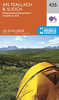
An Teallach and Fisherfield area of Scottish Highlands at 1:25, 000 on a waterproof and tear-resistant, GPS compatible map from Harvey Map Services in their Superwalker series covering popular hiking areas of Great Britain and Ireland, annotated with additional information for walkers.Maps in Harvey’s Superwalker series have contours at 15m intervals, with additional graphics for various types of terrain (crags, large boulders, scattered rocks) and colouring for different kinds of land use or vegetation (pastures, bogs, forests or woodland, etc). The maps show local hiking paths, indicating where appropriate long-distance routes, and boundaries of national parks or other protected areas. Scottish titles also indicate Munro, Corbett and Graham hills. Some maps additionally
highlight local cycle routes. A range of symbols mark various facilities for walkers including youth or independent hostels, campsites and caravan sites, information points, etc. Each map has a 1-km British or Irish national grid.To see other titles in this series please click on the series link.
highlight local cycle routes. A range of symbols mark various facilities for walkers including youth or independent hostels, campsites and caravan sites, information points, etc. Each map has a 1-km British or Irish national grid.To see other titles in this series please click on the series link.
Product Description
Reviews/Comments
Add New
Vouchers
No voucher codes found.
Do you know a voucher code for this product or supplier? Add it to Insights for others to use.
Do you know a voucher code for this product or supplier? Add it to Insights for others to use.
 Denmark