More From Contributor

£9.99
Character assassination in presidential politics is as American as apple pie. Anything for a Vote is a whimsical look at 200+ years of dirty tricks & bad behavior in presidential elections
- from John Adams to present day. In the tradition of our popular Secret Lives of the U.S. Presidents, this book is another rollicking ride through American history. It's also a valuable reminder that history does repeat itself, that lessons can be learned from the past (though usually aren't), & that even some iconic American figures are not above reproach when it comes to the dirtiest game of all
- presidential politics.

...
Archived Product
£8.99
An unforgettable cast of small-town characters copes with love & loss from the No. 1 New York Times bestselling & Man Booker long-listed author of My Name is Lucy Barton Recalling Olive Kitteridge in its richness, structure, & complexity, Anything Is Possible explores the whole range of human emotion through the intimate dramas of people struggling to understand themselves & others. Anything is Possible tells the story of the inhabitants of rural, dusty Amgash, Illinois, the hometown of Lucy Barton, a successful New York writer who finally returns, after seventeen years of absence, to visit the siblings she left behind. Reverberating with the deep bonds of family, & the hope that comes with reconciliation, Anything Is Possible again underscores Elizabeth Strout`s place as one of America`s most respected & cherished authors. ...
Archived Product
£12.99
An unforgettable cast of small-town characters copes with love & loss from the No. 1 New York Times bestselling & Man Booker long-listed author of My Name is Lucy Barton Recalling Olive Kitteridge in its richness, structure, & complexity, Anything Is Possible explores the whole range of human emotion through the intimate dramas of people struggling to understand themselves & others. Anything is Possible tells the story of the inhabitants of rural, dusty Amgash, Illinois, the hometown of Lucy Barton, a successful New York writer who finally returns, after seventeen years of absence, to visit the siblings she left behind. Reverberating with the deep bonds of family, & the hope that comes with reconciliation, Anything Is Possible again underscores Elizabeth Strout`s place as one of America`s most respected & cherished authors. ...
Archived Product
£8.99
In more than twenty years, Jon Frost has worked with the mad, the bad, the brave, the stupid, the spectacular & the heroic. In Jon`s time as a uniformed officer he seized presidential aircraft, a working tank, cars, lorries, boats & coffins; & uncovered wild animals, killer snakes, bush meat, animal porn, poisonous vodka, dodgy medicine, bootleg prescriptions, pirated pills, toxic alcohol, firearms, side-arms, swords, explosives, stolen gold, dirty money, blood diamonds, child pornography & every drug known to man & a few as yet unknown ones. & the dead? He searched them too. When you`ve confiscated everything from a suitcase full human hair to a live monkey hidden in the lining of someone`s overcoat, you know you can never return to a normal line of work. But then Jon went into plain clothes & undercover customs work & things became really interesting... ...
Archived Product
£11.99
The Ottoman Empire, 1915 On the Black Sea coast, Anyush Charcoudian dances at her friend`s wedding, dreaming of a life beyond her small Armenian village. Defying tradition, she embarks on a secret & dangerous affair with a Turkish officer, Captain Jahan Orfalea. As the First World War rages, the Armenian people are branded enemies of the state, & atrocities grow day by day. Torn apart & catapulted into a struggle to survive in the face of persecution & hatred, the lovers strive desperately to be reunited. ...
Archived Product
£13.99
Anza-Borrego Desert Region in California at 1:72, 000 approx in a series of detailed, contoured maps from Earthwalk Press with cartography based on the USGS topographic survey of the country plus additional information for visitors, printed on light, waterproof & tear-resistant synthetic paper. Coverage

Includes::
Cuyamaca Rancho State Parks, Laguna Mountain & Pine Creek Wilderness in Cleveland National Forest, Ocotillo Wells S.V.R.A., southern section of Pacific Crest Trail, etc. Maps in this series have contours usually at 40 feet & all heights are also given in feet. Colouring shows forested areas, plus, where necessary, additional graphics indicate other important topographic features such as marshland/swamps, moraine, etc. Hiking trails are highlighted, showing where appropriate their trail numbers and/or names. Icons highlight locations of trailheads, campgrounds, picnic areas, ranger stations, plus where available other recreational facilities. Local road network indicates light duty & unimproved dirt roads. GPS coordinates are given as margin ticks. Each title

Includes::
comprehensive additional text with useful information, including weather & water warning, regulations, etc, usually prepared by local summer rangers with good knowledge of the area.


...
Archived Product
£13.99
Anzio Landings: Operation Shingle & the Battle for Rome shown on a detailed map at 1:100, 000 based on the Italian topographic survey, with overprint showing front lines, coastal defences, names of army units on both sides, military museums, etc. The map covers an area from the coastal defences south of Latina to just beyond Rome, & inland to show the main attack lines of Operation Diadem. The overprint shows coastal defences & the direction of the landing forces, different front lines, positions of different army units with dates & directions of assaults, directions of various offensives, locations of tank battles, cemeteries of various combatant forces, military museums, etc. On the reverse there are numerous contemporary photos & notes on the Battle for Rome, as well as addresses of local military museums & cemeteries. Map legend & all the text are in Italian & English. ...
Archived Product
£6.95
Topographic coverage of mainland Spain at 1:50, 000 in the MTN50 (Mapa Topográfico Nacional) series from the Centro Nacional de Información Geografica, the country’s civilian survey organization. The maps have contours at 20m intervals, enhanced by relief shading, plus colouring and/or graphics to show different types of terrain, vegetation or land use. Boundaries of national parks & other protected areas are marked. In addition to all the usual information featured on topographic mapping at this scale, detailed presentation of the road & rail networks, rural tracks & paths, etc, the maps also show campsites & mountain refuges. On more recent editions some GRs, the official long-distance hiking routes, are also marked (although not as clearly as on hiking maps from other publishers). Each map covers 29.5x 18.5 km (with adjustments in the border or coastal areas). The maps have a 1-km UTM grid, plus margin ticks for latitude & longitude at 1` intervals. Map legend is in Spanish only.HOW TO CHOOSE THE RIGHT 50K MAP: all the titles in CNIG’s 200K Provincial Road Maps series at 1:200, 000 are overprinted with the grid for the 1:50, 000 maps & can be used to see the area covered by each 50K title. TO SEE THE LIST OF TITLES IN THIS SERIES PLEASE CLICK ON THE SERIES LINK.PLEASE NOTE
- MAP TITLES: the grids shown on our website serve both the civilian & the military 1:50, 000 topographic series. Although the areas covered by maps in both series are identical (apart from some border or coastal sheets), occasionally map titles differ – only one title is shown on the grid, usually the military one. In Galicia, the Basque country & in the Catalan speaking areas the tendency now is to use local place names rather than the often better known Castilian ones. Where possible, both versions are included in our titles. Map titles listed on our website are based on information received by us at the time of publication, but sometimes maps arrive showing a completely different title! As long as the map number is as ordered, the correct map has been supplied.
...
Archived Product
£9.95
One of the titles in a series of topographic maps of popular walking & recreational areas of New Zealand with contours at 20m intervals & relief shading. Perennial snow & ice contours are marked in blue & terrain information

Includes::
cliffs, saddles, moraine, scree, forest, scrub, etc. The maps show tracks & footpaths, with some paths indicating walking distances between marked points. A range of symbols depict campsites, huts, shelters, toilets & parking areas, fuel supplies, places of interest, etc. Latitude & longitude margin ticks are at 1' intervals, & the New Zealand Map Grid is printed over the map. In this title: detailed topographic mapping of Mount Cook & adjacent ranges. The map is centred on the Tasman Glacier & extends out to the towns of Fox Glacier & Aoraki in the north & south, & to the Liebig Range & the Sierra Range in the east & west respectively.

...
Archived Product
£13.99
Aoraki / Mount Cook area at 1:65, 000 in a series of contoured & GPS compatible maps from New Topo NZ Ltd, with exceptionally vivid presentation of the terrain, routes clearly highlighted & symbols to show locations of various facilities. The overprint distinguishes between walking tracks, tramping tracks, tramping routes & lightly marked routes. Also marked is a cycle track from Aoraki / Mount Cook village to Foliage Hill & Tasman Lake. Symbols show huts with the number of bunks, campsites, public toilets, viewpoints, etc. Contour interval is 20 metres & the map has a 1-km NZ national grid, plus latitude & longitude lines at 10’. Maps in the series from New Topo NZ Ltd cover the country’s popular hiking & tramping areas. The maps have contours (20m in most titles
- please confirm in the individual description) enhanced by relief shading, plus colouring and/or graphics to indicate various types of the terrain & vegetation: glaciers, scree, lava flows, shingle, s&, swamps, exotic forest, scrub, native bush, etc. The overprint for the routes distinguishes, as appropriate, between tramping tracks & routes, walking tracks, & waymarked or unmarked trails. Symbols show facilities such huts, campsites, public toilets, viewpoints, car parks, etc. Where useful, the maps also have brief notes about hut reservations. All the titles are GPS compatible, most with a 1-km NZ national grid (GPS users can uses WGS84). To see all the titles in this series please click on the series link.
...
Archived Product

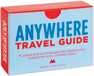
Anywhere: A Travel Guide: 75 Prompts For Journeys Near And Far

A travel guide for anywhere near or far, this handy deck of cards includes 75 unique prompts to inspire exploration and adventure. Featuring a mix of concrete actions (like `Eat a dessert for breakfast, three appetizers for lunch, and a breakfast for dinner`) and more whimsical actions (like `Write down what you like about this city on a small piece of paper. Leave it where someone else will find it later). These cards embrace the `how` of travelling rather than the `where`, allowing users to discover new places and rediscover familiar places.
RIP - This product is no longer available on our network. It was last seen on 25.09.2019

This page now acts as a permanent archive for this product. Add more information using the comments box below to ensure it can still be found by future generations.

Use our search facility to see if it is available from an alternative contributor.
  • External links may include paid for promotion
  • Availability: Out Of Stock
  • Supplier: Stanfords
  • SKU: 9781452119045
Availability: In Stock
£11.99

Product Description

A travel guide for anywhere near or far, this handy deck of cards

Includes::
75 unique prompts to inspire exploration & adventure. Featuring a mix of concrete actions (like ` Eat a dessert for breakfast, three appetizers for lunch, & a breakfast for dinner`) & more whimsical actions (like ` Write down what you like about this city on a small piece of paper. Leave it where someone else will find it later). These cards embrace the `how` of travelling rather than the `where`, allowing users to discover new places & rediscover familiar places.

Reviews/Comments

Add New

Intelligent Comparison

Oooops!
We couldn't find anything!
Perhaps this product's unique.... Or perhaps we are still looking for comparisons!
Click to bump this page and we'll hurry up.

Price History

Vouchers

No voucher codes found.
Do you know a voucher code for this product or supplier? Add it to Insights for others to use.

Facebook

Jargon Buster

Paper - A thin sheet mainly used for writing. Available in a variety of colours. Made mainly from wood pulp.
Lunch - A midday meal
Small - something that takes up less space than normal.
Adventure - an undertaking of an exciting challenge or experience.

Supplier Information

Stanfords
Stanfords was established in 1853 and opened their iconic Covent Garden flagship store in 1901. They have become the top retailer of maps, travel books and accessories in the UK and arguably offer the largest selection of maps and travel books worldwide. Famous names such as Captain Robert Falcon Scott, Ranulph Fiennes and Michael Palin have purchased from Stanfords. They now have a shop in Bristol and both stores together with other venues operate a calendar of events including talks, book signings and exhibitions. As a specialist map retailer, the map selection is comprehensive and includes road maps, street maps and walking maps from worldwide destinations, as well as a selection of world atlases and wall maps. Books include travel guides and travel literature. Stanfords also stock globes, from miniatures made of blue marble to magnificent floor-standing globes. The website features a selection of interesting articles on travel topics.
Page Updated: 2023-11-12 20:15:36

Community Generated Product Tags

Oh No! The productWIKI community hasn't generated any tags for this product yet!
Menu