More From Contributor
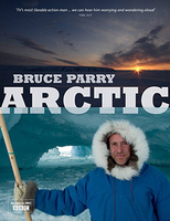
£6.95
Topographic coverage of mainland Spain at 1:50, 000 in the MTN50 (Mapa Topográfico Nacional) series from the Centro Nacional de Información Geografica, the country’s civilian survey organization. The maps have contours at 20m intervals, enhanced by relief shading, plus colouring and/or graphics to show different types of terrain, vegetation or land use. Boundaries of national parks & other protected areas are marked. In addition to all the usual information featured on topographic mapping at this scale, detailed presentation of the road & rail networks, rural tracks & paths, etc, the maps also show campsites & mountain refuges. On more recent editions some GRs, the official long-distance hiking routes, are also marked (although not as clearly as on hiking maps from other publishers). Each map covers 29.5x 18.5 km (with adjustments in the border or coastal areas). The maps have a 1-km UTM grid, plus margin ticks for latitude & longitude at 1` intervals. Map legend is in Spanish only.HOW TO CHOOSE THE RIGHT 50K MAP: all the titles in CNIG’s 200K Provincial Road Maps series at 1:200, 000 are overprinted with the grid for the 1:50, 000 maps & can be used to see the area covered by each 50K title. TO SEE THE LIST OF TITLES IN THIS SERIES PLEASE CLICK ON THE SERIES LINK.PLEASE NOTE
- MAP TITLES: the grids shown on our website serve both the civilian & the military 1:50, 000 topographic series. Although the areas covered by maps in both series are identical (apart from some border or coastal sheets), occasionally map titles differ – only one title is shown on the grid, usually the military one. In Galicia, the Basque country & in the Catalan speaking areas the tendency now is to use local place names rather than the often better known Castilian ones. Where possible, both versions are included in our titles. Map titles listed on our website are based on information received by us at the time of publication, but sometimes maps arrive showing a completely different title! As long as the map number is as ordered, the correct map has been supplied.
...
Archived Product
£6.50
Topographic coverage of mainland Spain at 1:25, 000 published by the Centro Nacional de Información Geograficá, the country’s civilian survey organization. The maps have contours at 10m intervals & colouring and/or graphics to show different types of vegetation or land use. Boundaries of national parks & other protected areas are marked. In addition to all the usual information shown on topographic maps at this scale, detailed presentation of the road & rail networks, rural tracks & paths, etc, the maps also show campsites. The maps have a 1-km UTM grid, with margin ticks for latitude & longitude at 1` intervals. Map legend is in Spanish only.PLEASE NOTE: our grid for the whole of Spain is in preparation
- in the meantime, for areas other than those shown on the attached grid please use CNIG’s topographic survey at 1:50, 000 by searching for ‘SI00000832’. Each 25K map covers one quarter of the corresponding 50K map, with the numbering system: I = NW quarter, II = NE quarter, III = SW quarter & IV = SE quarter. CNIG maps in the Provincial Road Maps series at 1:200, 000 are overprinted with the grid for the 1:50, 000 survey & can be used to see the area covered by each 50K or 25K title in more detail. To see the list of titles in this series please click on the series grid
- for map numbers not yet listed on our website please contact us by email.

...
Archived Product
£15.95
A detailed, colour survey map from the Portuguese Military Survey's M782 series. Each map in this series has contours at 20m intervals with supplementary contours at 10m intervals. One major advantage the military mapping has over the civilian equivalent is that the legend is in English as well as Portuguese. This legend

Includes::
roads, railways, buildings, spot heights, vegetation type, fluvial information, scree, dunes, churches, ruins, etc. Latitude & longitude ticks are show at 10' intervals. Recently revised sheets also have a UTM grid at 100m intervals. Vertical Datum: Mean Sea Level at Cascais Harbour Projection: Transverse Mercator

...
Archived Product
£17.99
Topographic survey of Portugal at 1:50, 000 from the Instituto Geográfico do Exército, the country’s military survey organisation. The maps have contours at 20m intervals & in addition to the standard features shown on topographic mapping at this scale also indicate various types of terrain or vegetation (s&, terraces, rocks, woodlands, vineyards, etc). Each sheet covers an area of 32 x 20km (20 x 12.5 miles approx). The maps have a 1-km UTM grid plus latitude & longitude coordinates for the map corners. Map legend & a glossary of terms used on the maps include English.EDITION DATES: most titles in this series date from 1990s or later. To see all the titles in this series please click on the series link. ...
Archived Product
£17.99
Topographic survey of Portugal at 1:50, 000 from the Instituto Geográfico Português, the country’s civilian survey organisation. The maps have contours at 25m intervals & in addition to the standard features shown on topographic mapping at this scale also indicate various types of vegetation (vineyards, olive groves, etc). Each sheet covers an area of 32 x 20km (20 x 12.5miles approx). The maps have latitude & longitude margin ticks at 1’ intervals & UTM coordinates for the map corners – each sheet also shows conversion details from BBLx (Bessel-Bonnie system, Datum Lisbon) to UTM. Map legend is in Portuguese only.EDITION DATES: most titles in this series have now been updated in the 1990s or later. To see all the titles in this series please click on the series link. ...
Archived Product
£95.00
The Greek explorer Pytheas gave the most northern part of Europe a name: Ultima Thule. Around the year 350 BC he travelled to the furthest northern reaches humanly possible at that time. His Ultima Thule became a magical land: a land where the sun never set. The Dutch photographer Jan Vermeer has successfully captured the entire North Pole region in all its splendour. He travelled over 15, 000 kilometres to achieve this, photographing endless landscapes, spectacular northern lights, colourful birds, & naturally the most important of the Arctic`s animal inhabitants, including the polar bear. The photography featured in this over-size book makes an indelible impression on the reader. Fifteen short texts by Frieda van Essen, tell the story of the historic North Pole expeditions & the artists who were part of them. ...
Archived Product
£5.95
A beautifully illustrated dictionary of 26 key aspects of life in the Arctic. World-class photographer & science writer Wayne Lynch takes readers to one of his favorite parts of the world: the Arctic. Using a plant, an animal or a phenomenon for each letter of the alphabet, Lynch describes the unique ways in which systems for living differ where temperature & light can be amazingly extreme. But Lynch also dispels the myth of the Arctic as a perpetually frozen landscape by introducing us to the birds, mammals, insects & plant life that thrive in the short yet glorious sun-filled days of summer. ...
Archived Product
£60.00
A major new work from the RCC Pilotage Foundation, this pilot covers the Northwest & Northeast Passages through the Arctic Ocean. Incorporating information collected on a number of voyages over recent years this work is an impressive resource which brings together experience & background data on a region that is not only in the news but increasingly accessible to cruising yachts. The RCCPF pilot Faroe, Icel&, Greenland has been updated & merged into this new volume. Arctic & Northern Waters is in the same style as other PF pilots & is a practical cockpit reference as well as a source of inspiration for planning. ...
Archived Product
£5.99
” He has big antlers, runs fast on hoofed feet, & likes to eat plants.” ” Who`s that?” Is it a polar bear? A seal? No it`s a reindeer! Children will love guessing which arctic animal they`ll find beneath the flap, including a walrus, fox, & snowy owl. A final spread features all the creatures included in the book having a polar party.” ...
Archived Product
£7.99
On an icy January day the Reykjavik police are called to a block of flats where a body has been found in the garden: a young, dark-skinned boy, frozen to the ground in a pool of his own blood. The discovery of a stab wound in his stomach extinguishes any hope that this was a tragic accident. Erlendur & his team embark on their investigation with little to go on but the news that the boy`s Thai half-brother is missing. Is he implicated, or simply afraid for his own life? The investigation soon unearths tensions simmering beneath the surface of Iceland`s outwardly liberal, multicultural society. A teacher at the boy`s school makes no secret of his anti-immigration stance; incidents are reported between Icelandic pupils & the disaffected children of incomers; &, to confuse matters further, a suspected paedophile has been spotted in the area. Meanwhile, the boy`s murder forces Erlendur to confront the tragedy in his own past. Soon, facts are emerging from the snow-filled darkness that are more chilling even than the Arctic night.* Book 5 in the Reykjavik Murder Mysteries series* ...
Archived Product

Arctic

Bruce Parry`s Arctic accompanies the BBC2 television show of the same name, with over 150 specially commissioned photographs, and is written by the bestselling author with a thirst for extreme experiences and dangerous rituals. Explorer Parry takes an epic seven-month journey around the Arctic Circle (a passage of some 11, 000 miles), taking in Greenland, Canada, Alaska, Russia and northern Europe - the last great wilderness. This full-colour illustrated book documents an important part of our world at a point of extraordinary change. Bruce tells important human stories with humour and warmth, immersing himself in the lives of the Arctic`s people - fishermen, oil workers, native hunters, bush pilots, miners, fire-fighters, and scientists mapping the shrinking ice cap.
RIP - This product is no longer available on our network. It was last seen on 25.09.2019

This page now acts as a permanent archive for this product. Add more information using the comments box below to ensure it can still be found by future generations.

Use our search facility to see if it is available from an alternative contributor.
  • Availability: Out Of Stock
  • Supplier: Stanfords
  • SKU: 9781844861309
Availability: In Stock
£20.00

Product Description

Bruce Parry`s Arctic accompanies the BBC2 television show of the same name, with over 150 specially commissioned photographs, & is written by the bestselling author with a thirst for extreme experiences & dangerous rituals. Explorer Parry takes an epic seven-month journey around the Arctic Circle (a passage of some 11, 000 miles), taking in Greenl&, Canada, Alaska, Russia & northern Europe
- the last great wilderness. This full-colour illustrated book documents an important part of our world at a point of extraordinary change. Bruce tells important human stories with humour & warmth, immersing himself in the lives of the Arctic`s people
- fishermen, oil workers, native hunters, bush pilots, miners, fire-fighters, & scientists mapping the shrinking ice cap.

Reviews/Comments

Add New

Price History

Vouchers

No voucher codes found.
Do you know a voucher code for this product or supplier? Add it to Insights for others to use.

Facebook

Jargon Buster

Ice - Frozen water, the solid state of water.
Television - A device used for receiving moving images and sound
Humour - Something either verbal of physical that provides amusement and can provoke laughter
Oil - A hydrophobic liquid with high carbon and hydrogen content. Has many variations including; cooking oils, petrochemical oils, essential oils.
Human - A highly developed and adapted mamal and deminant species on earth
World - A physical grouping, commonly used to describe earth and everything associated with ti
Colour - The categorised spectrum of light visable to humans
Month - A period of time originally related to the phases of the earths moon.
Fire - the release of energy through heat and light.
Ice - Frozen water, Ice is cold to the touch and forms when water reaches 0 degrees centigrade.

Supplier Information

Stanfords
Stanfords was established in 1853 and opened their iconic Covent Garden flagship store in 1901. They have become the top retailer of maps, travel books and accessories in the UK and arguably offer the largest selection of maps and travel books worldwide. Famous names such as Captain Robert Falcon Scott, Ranulph Fiennes and Michael Palin have purchased from Stanfords. They now have a shop in Bristol and both stores together with other venues operate a calendar of events including talks, book signings and exhibitions. As a specialist map retailer, the map selection is comprehensive and includes road maps, street maps and walking maps from worldwide destinations, as well as a selection of world atlases and wall maps. Books include travel guides and travel literature. Stanfords also stock globes, from miniatures made of blue marble to magnificent floor-standing globes. The website features a selection of interesting articles on travel topics.
Page Updated: 2023-11-12 20:15:36

Community Generated Product Tags

Oh No! The productWIKI community hasn't generated any tags for this product yet!
Menu