More From Contributor
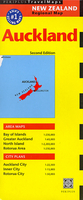
£7.99
Longlisted for the Carnegie Medal 2017. Aubrey`s father, Jim, has fallen under an horrendous spell, which Aubrey is determined to break. Everyone says his task is impossible, but Aubrey will never give up & never surrender
- even if he must fight the unkillable Spirit of Despair itself: the TERRIBLE YOOT!
...
Archived Product
£12.99
Topographic survey of France at 1:25, 000 in IGN`s excellent TOP25 / Série Bleue series. All the maps are GPS compatible, with a 1km UTM grid plus latitude & longitude lines at 5’ intervals. Contours are at 5m intervals except for mountainous areas where the maps have contours at 10m intervals, vividly enhanced by hill shading & graphics for rocky terrain. Colouring with graphics indicates different types of vegetation or land use (deciduous or coniferous forests, moors, orchards, vineyards, etc). PLEASE NOTE: coverage of France at this scale is currently being revised – the format & the presentation of each title are indicated by the letters at the end of its Sheet Reference number (e.g. 0416ET, 3531ETR, 1923SB, etc.)MAPS WITH FULL TOURIST OVERPRINT & AN ENGLISH MAP LEGEND: all TOP25 maps & the SB editions of Série Bleue have an overprint highlighting waymarked walking trails including long-distance GR routes &, where appropriate, ski routes. Symbols indicate campsites, gîtes d’etape, refuges, equestrian centres & other recreational facilities or sites, tourist information centres, cultural heritage, etc. Towns & locations of particular interest are highlighted.- ET or OT = single-sided TOP25 map covering approx. 29x 21 km / 18x 13 miles.- ETR or OTR = waterproof & tear resistant TOP25 map covering the same area as the corresponding ET or OT number, but double-sided, printed on a smaller size sheet with a good overlap between the sides.- SB = Série Bleue map with full tourist overprint; these maps, first introduced in summer 2014, each cover approx. 29x 24km / 18x 15 miles.SÉRIE BLEUE maps with numbers ending in E (Est) or O (Ouest): most editions now indicate the GR routes, but do not show any other tourist information. Map legend is in French only. Each map covers approx. 14x 20km / 9x 12 miles. ...
Archived Product
£2.50
Auchinleck street map from Nicolson Maps; coverage

Includes::
Catrine, Dalrymple, Mauchline, Sorn & Tarbolton.

...
Archived Product
£2.50
Auchterarder street map from Nicolson Maps; coverage

Includes::
Blackford, Braco, Comrie, Crieff, Dunning,

...
Archived Product
£3.50
Auchterarder in 1900 in a fascinating series of reproductions of old Ordnance Survey plans in the Alan Godfrey Editions, ideal for anyone interested in the history of their neighbourhood or family. Most of the town centre is covered including Townhead, High Street, Feus, etc. Coverage extends south to the railway & part of the station, eastward to Mill West Mill, north to Castle Mains, & west to Lower & Upper Borelandpark. Features include St Kessog`s church, Coll Earn, Ruthven Tower, Castleton, Castlebrae, etc. A 1921 trade directory is on the reverse. About the Alan Godfrey Editions of the 25” OS Series: Selected towns in Great Britain & Ireland are covered by maps showing the extent of urban development in the last decades of the 19th & early 20th century. The plans have been taken from the Ordnance Survey mapping & reprinted at about 15 inches to one mile (1:4, 340). On the reverse most maps have historical notes & many also include extracts from contemporary directories. Most maps cover about one mile (1.6kms) north/south, one & a half miles (2.4kms) across; adjoining sheets can be combined to provide wider coverage.FOR MORE INFORMATION & A COMPLETE LIST OF ALL AVAILABLE TITLES PLEASE CLICK ON THE SERIES LINK. ...
Archived Product
£9.99
Double-sided map combining indexed street plan of Auckland with its inner suburbs, a plan of central Wellington & a road map of New Zealand’s North Isl&, plus a street plan of central Christchurch thrown in as a bonus! All three street plans are at 1:12, 500 & show commuter rail lines with stations, ferry lines, plus in Wellington cable-car & electric trolley bus routes. Places of interest, public buildings & various facilities are marked, as well as numerous hotels, etc. Auckland & Wellington also have small insets showing the environs. On the reverse is an indexed map of the North Island & the northern tip of the South Island at 1:950, 000 with altitude colouring. The map shows road & rail networks & indicates national parks & other protected areas. Symbols mark campsites & caravan sites, beaches & surfing areas, hot springs, & various places of interest. Latitude & longitude lines are drawn at 1º intervals. Also included are small insets with New Zealand’s offshore islands: Antipodes, Auckl&, Bounty, Campbell & Chatham. ...
Archived Product
£8.99
Auckland
- Coromandel region of New Zealand`s North Isl&, including Thames, Hamilton & Tauranga, on a detailed, indexed road
...
Archived Product
£21.95
Auckland & 25 Regional Towns Complete Street Directory: comprehensive, indexed, 160-page, spiral-bound street directory with all the sections clearly colour-coded for easy reference. Scales vary, with the main part of the atlas at 1:25, 000, Northern Towns at 1:27, 500 or 1:30, 000 & West Auckland at 1:75.000. An enlargement shows the central area of Auckland at a more detailed scale of 1:11.000. Also included is a map of the whole region at 1:175, 000. Comprehensive 44-page index

Includes::
lists of coastal & water features, parks, reserves & forest, motor camps & dumps stations, golf courses, shopping centres, etc. Towns covered are: Algies Bay, Awana, Beachlands, Clarks Beach, Clevendon, Glenbrook Beach, Helensville, Kawakawa Bay, Leigh, Mahurangi East, Maraetai, Medlands, Muriwai Beach, Omaha, Parakai, Piha, Point Wells, Pukekohe, Snells Beach, Tryphena, Tuakau, Waiheke Isl&, Waimauku, Waiwere, Warkworth & Wellsford.

...
Archived Product
£23.99
Auckland & 25 Regional Towns Complete Street Directory: comprehensive, indexed, 160-page, spiral-bound street directory with all the sections clearly colour-coded for easy reference. Scales vary, with the main part of the atlas at 1:25, 000, Northern Towns at 1:27, 500 or 1:30, 000 & West Auckland at 1:75.000. An enlargement shows the central area of Auckland at a more detailed scale of 1:11.000. Also included is a map of the whole region at 1:175, 000. Comprehensive 44-page index

Includes::
lists of coastal & water features, parks, reserves & forest, motor camps & dumps stations, golf courses, shopping centres, etc. Towns covered are: Algies Bay, Awana, Beachlands, Clarks Beach, Clevendon, Glenbrook Beach, Helensville, Kawakawa Bay, Leigh, Mahurangi East, Maraetai, Medlands, Muriwai Beach, Omaha, Parakai, Piha, Point Wells, Pukekohe, Snells Beach, Tryphena, Tuakau, Waiheke Isl&, Waimauku, Waiwere, Warkworth & Wellsford.

...
Archived Product
£8.50
Auckland & environs in a series of maps covering various districts of New Zeal&, with each title combining a detailed road map with street plans of local towns, all with road & street indexes. The maps are published in two formats: handy Pocket Maps or Pathfinders with, as the publishers put it “ Larger print so you don’t squint”. The road maps, typically around 1:175, 000
- 1:275, 000, show local roads & 4WD tracks. Main sightseeing routes across the country, such as the Pacific Road Highway or Thermal Explorer Highway, are identified by small icons. Railways, local airports & where appropriate, ferry routes are shown. The maps also include selected local hiking tracks. A range of symbols highlight various places of interest & sport or recreational facilities. Topography is indicated by names of mountain ranges & selected peaks. Colouring shows forested areas, with national parks & reserves highlighted. The maps have no geographical coordinates but each one has an index listing names of local roads. Each title also

Includes::
numerous street plans of the main centres of population in the area covered by the road map. The plans are usually at 1:25, 000 to 1:35, 000, & for larger towns an enlargement of the town centre is also provided. The plans shows one way streets, public buildings & various facilities, including sport & recreational centres &, almost invariably, public toilets. Each plan has a separate street index. * In this title:* Auckland city centre at 1:11, 000 scale on one side & a road map of the district at 1:175, 000 on the reverse.


...
Archived Product

Auckland

Auckland on a double-sided map from Periplus combining street plans and road maps of popular areas within easy reach of the city, all annotated with places of interest and various facilities, etc. Each panel clearly indicates areas covered by its more detailed enlargements.On one side is a street plan of the city at 1: 22, 500, accompanied by an enlargement of the centralarea at 1:15, 000. The plans highlight numerous places of interest and facilities such as taxi ranks or bus stations, selected accommodation, etc. In addition to the street index there is also a separate index of parks, places of interest, shopping centres, health care facilities, etc. On the reverse Greater Auckland is shown on a plan at 1:60, 000 highlighting main streets and access roads. Also provided is a map
of the North Island (1:2, 200, 000) with enlargements for the Bay of Islands and the Rorotua area (both 1:230, 000), all annotated with numerous places of interest, plus a street plan of Rotorua City (1:50, 000).
RIP - This product is no longer available on our network. It was last seen on 25.09.2019

This page now acts as a permanent archive for this product. Add more information using the comments box below to ensure it can still be found by future generations.

Use our search facility to see if it is available from an alternative contributor.
  • Availability: Out Of Stock
  • Supplier: Stanfords
  • SKU: 9780794600334
Availability: In Stock
£6.99

Product Description

Auckland on a double-sided map from Periplus combining street plans & road maps of popular areas within easy reach of the city, all annotated with places of interest & various facilities, etc. Each panel clearly indicates areas covered by its more detailed enlargements. On one side is a street plan of the city at 1: 22, 500, accompanied by an enlargement of the centralarea at 1:15, 000. The plans highlight numerous places of interest & facilities such as taxi ranks or bus stations, selected accommodation, etc. In addition to the street index there is also a separate index of parks, places of interest, shopping centres, health care facilities, etc. On the reverse Greater Auckland is shown on a plan at 1:60, 000 highlighting main streets & access roads. Also provided is a map of the North Island (1:2, 200, 000) with enlargements for the Bay of Islands & the Rorotua area (both 1:230, 000), all annotated with numerous places of interest, plus a street plan of Rotorua City (1:50, 000).

Reviews/Comments

Add New

Price History

Vouchers

No voucher codes found.
Do you know a voucher code for this product or supplier? Add it to Insights for others to use.

Facebook

Jargon Buster

Road - a manmade lane or a path that is used to speed up travel.
Accommodation - A room in which someone can live in, for example in a hotel
Popular - Something that is admired and liked by many people.

Supplier Information

Stanfords
Stanfords was established in 1853 and opened their iconic Covent Garden flagship store in 1901. They have become the top retailer of maps, travel books and accessories in the UK and arguably offer the largest selection of maps and travel books worldwide. Famous names such as Captain Robert Falcon Scott, Ranulph Fiennes and Michael Palin have purchased from Stanfords. They now have a shop in Bristol and both stores together with other venues operate a calendar of events including talks, book signings and exhibitions. As a specialist map retailer, the map selection is comprehensive and includes road maps, street maps and walking maps from worldwide destinations, as well as a selection of world atlases and wall maps. Books include travel guides and travel literature. Stanfords also stock globes, from miniatures made of blue marble to magnificent floor-standing globes. The website features a selection of interesting articles on travel topics.
Page Updated: 2023-11-12 20:15:36

Community Generated Product Tags

Oh No! The productWIKI community hasn't generated any tags for this product yet!
Menu