
 United Kingdom
 France
 Germany
 Netherlands
 Sweden
 USA
USA
 Italy
Italy
 Spain
Spain
More From Contributor


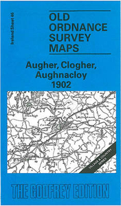
Augher, Clogher And Aughnacloy 1902
Augher, Clogher and Aughnacloy in 1902 in the Alan Godfrey Edition of historical Ordnance Survey mapping at one inch to one mile. The map covers much of southern Co. Tyrone, including the little towns of Caledon, together with an expanse of rural north Co. Monaghan. There are also small segments of Counties Fermanagh and Armagh. Coverage stretches from Carryclogher eastward to Tynan, and from Ballygawley southward to Middletown. Features include a substantial stretch of the Clogher Valley Railway, a small stretch of the Great Northern Railway, Tynan Abbey, Slieve Beagh, Favor Royal, Fort Singleton, Caledon House and Glaslough House. On the reverse are three detailed town plans at a scale of 18 inches to the mile, covering Aughnacloy, including Main Street with houses either
side neatly delineated, Corn Market, St James Church, St Mary`s RC church, Jackson Institute, station with engine shed; Augher, with creamery, station and Clogher Valley Railway, St Mark`s church, flax mill, Augher Castle; plus Clogher with St Macartin`s Cathedral, Clogher Park House, Fair Green etc. About Alan Godfrey Editions of OS 1” to 1 mile maps of Ireland:The maps provide an invaluable overview of a wider area, typically 18 x 12 miles (29 x 19kms approx.), and offer historical mapping for small villages not covered by the more detailed series for which the Godfrey Editions are better known. All the maps include historical notes and all, unless indicated in the individual description, also include a large scale map of a small town or village in the area.
side neatly delineated, Corn Market, St James Church, St Mary`s RC church, Jackson Institute, station with engine shed; Augher, with creamery, station and Clogher Valley Railway, St Mark`s church, flax mill, Augher Castle; plus Clogher with St Macartin`s Cathedral, Clogher Park House, Fair Green etc. About Alan Godfrey Editions of OS 1” to 1 mile maps of Ireland:The maps provide an invaluable overview of a wider area, typically 18 x 12 miles (29 x 19kms approx.), and offer historical mapping for small villages not covered by the more detailed series for which the Godfrey Editions are better known. All the maps include historical notes and all, unless indicated in the individual description, also include a large scale map of a small town or village in the area.

Product Description
Reviews/Comments
Add New
Vouchers
No voucher codes found.
Do you know a voucher code for this product or supplier? Add it to Insights for others to use.
Do you know a voucher code for this product or supplier? Add it to Insights for others to use.
 Denmark