
 United Kingdom
 France
 Germany
 Netherlands
 Sweden
 USA
USA
 Italy
Italy
 Spain
Spain
More From Contributor


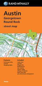
Austin - Georgetown - Round Rock TX Rand McNally
Austin in Texas, with Georgetown and Round Rock, on an indexed street plan from Rand McNally in their extensive range of maps covering cities in the United States. Insets provide a more detailed street plan of downtown Austin. Communities covered by this map include Cedar park, Leander, Pflugerville, Rollingwood, San Leanna, Sunset Valley, Village of Volente and West Lake Hills.NEW STREET PLAN CARTOGRAPHY FROM RAND McNALLY: Rand McNally are currently changing the cartography of their street plans to a more “European” style. In many titles streets are now shown by parallel lines, providing a much clearer, easier to read presentation. Better use of colouring indicates different types of land use and/or institutions (parks, shopping centres, academic institutions, etc) and,
in most titles, different administrative units. More streets are annotated with block numbers. Some new editions still retain the traditional American presentation of streets by a single line, but with more prominent marking for various institutions, facilities and places of interest. Our cartography sample indicates which style is used in this title.COVERAGE: Rand McNally street plans cover cities with their outer suburbs, prominently highlighting principal traffic arteries and connecting main streets. Railway and subway stations are marked.
in most titles, different administrative units. More streets are annotated with block numbers. Some new editions still retain the traditional American presentation of streets by a single line, but with more prominent marking for various institutions, facilities and places of interest. Our cartography sample indicates which style is used in this title.COVERAGE: Rand McNally street plans cover cities with their outer suburbs, prominently highlighting principal traffic arteries and connecting main streets. Railway and subway stations are marked.

Product Description
Reviews/Comments
Add New
Vouchers
No voucher codes found.
Do you know a voucher code for this product or supplier? Add it to Insights for others to use.
Do you know a voucher code for this product or supplier? Add it to Insights for others to use.
 Denmark