More From Contributor

£8.99
Bali Postcard Colouring Book contains 20 postcards (format 10.5 x 15 cm) of superior 250gsm acid-free & age resistant drawing paper, printed with 20 exceptional designs in very light lines. The printing is done in such a way that, depending on the techniques used, the original outline will be hardly visible after colouring. The first-rate paper is made to our specifications by one of the best paper mills in Europe & is suitable for a wide range of colouring applications, including pencil, crayon, pastel, felt marker, gouache, etc. Also water-colours & liquid inks can be used. Pepin Postcard Colouring Books match the quality of the finest artists` pads. They are perfectly suited to practice your colouring skills & create beautiful pieces at the same time. For best results, we recommend high-quality colouring materials. ...
Archived Product
£12.00
Bali is unlike anywhere else. Despite the advent of international tourism, this Indonesian island remains an untarnished cultural gem set in an idyllic landscape. Spirit-haunted as is the rest of Southeast Asia, Bali boasts a unique amalgam of beliefs because Hinduism overlays a much older relationship with the physical world. Nothing is considered to be inanimate. Towering volcanoes, majestic lakes, lush forests, gushing springs, flooded paddies, golden sands & blue seas
- all these spectacular features have convinced the Balinese that their island is in itself a cosmos. Even though Bali suffered under the Japanese during World War Two, in the struggle afterwards to expel the Dutch, & through the violence which accompanied the military overthrow of President Sukarno, the resilience & kindness of its inhabitants ensure that no visitor leaves the island today unimpressed by its heritage. LAND OF TEMPLES: Besides an estimated 20, 000 temples, there are hundreds of thousands of shrines for the good reason that hardly anywhere is said to lack divine significance.FESTIVALS & DRAMA: So widespread are places of worship that every village & town possesses its own religious festival, an important part of which is dance-drama. Most popular is the story of the defeat of the chief witch Rangda by the good lion Barong, but the audience knows that she will be back again. ART & HANDICRAFTS: Because the Balinese believe that making beautiful objects is pleasing to the gods, artists & craftsmen are highly esteemed. On display along roadsides are their astounding works, which range from monumental sculpture to bright textiles.
...
Archived Product
£7.99
The Balkans at 1:1, 200, 000 on a double-sided map from the Bulgarian publishers Domino, showing the region’s road network in detail & presenting its geography with bright altitude colouring. Coverage with full detail

Includes::
Romania & Moldova; the whole of Hungary is also on the map but with information limited to larger towns & principal roads. The map shows a large number of small towns & villages & provides names of various mountain ranges, etc. Presentation of place names varies:
- in Bulgaria names of larger town are in both Cyrillic & Latin alphabet; names smaller towns & villages & of geographical features are in Cyrillic only- in all the remaining countries (including Serbia) names of larger towns are in both scripts, with smaller locations & geographical features in Latin alphabet only The map is not indexed & has latitude & longitude lines at intervals of 1°. Map legend

Includes::
English.


...
Archived Product
£10.99
The Balkans & South-Eastern Europe on a road map from Freytag & Berndt, covering a large chunk of the Continent from southern Poland & Kiev to the Mediterranean, & from Naples to Ankara. The map shows the area’s road network, indicating diving distances on principal routes & main border crossings. Railways & ferry routes are marked. In most countries internal administrative boundaries are also shown. In Greece, Bulgaria & Ukraine (but not Serbia) names of main cities are shown both in Latin alphabet & in Greek or Cyrillic. The map has a latitude & longitude grid at intervals of 1º. Multilingual map legend

Includes::
English.A booklet attached to the map cover contains an index, arranged by country, plus street plan of central Athens, Belgrade, Bratislava, Budapest, Bucharest, Chisinau, Istanbul, Kiev, Ljubljana, Podgorica, Prague, Pristina, Sarajevo, Skopje, Tirana, Vienna & Zagreb

...
Archived Product
£17.99
The Balkans at 1: 1, 948, 000 on a political wall map from the NGS, size 77 x 59.5cm (30” x 23.5” approx) – encapsulated version, presenting the region their characteristic classic style: countries with a light base & international boundaries picked out in colour & the seas in light blue. Coverage extends from the Adriatic to the Black Sea & from the northern borders of Hungary & Moldova to central Greece. Country names are in their English versions; city names are as used in their countries, accompanied where appropriate by the English equivalent (Beograd/ Belgrade). In Greece & the countries using the Cyrillic alphabet all place names are shown in the Latin alphabet. Within Hungary, Romania, & Bulgaria internal administrative boundaries are marked, accompanied by lists with names of provinces & their capital cities (not for Bulgaria). Within Serbia the map shows the boundary of Vojvodina & in Bosnia-Herzegovina Republika Srpska is marked. The map shows principal road, rail & ferry connections & main international airports. Topography is in indicated by light relief shading with names of main geographical features. Latitude & longitude lines are drawn at 1° intervals. Please note: this map is also available on paper without the encapsulation.LAMINATED & ENCAPSULATED WALL MAPS:- LAMINATED wall maps have a thin layer of plastic usually applied to the printed side only. They can be written on with suitable marker pens without any damage to the map but, unless laminated on both sides, they are not damp-proof.- ENCAPSULATED wall maps are sealed between two sheets of plastic. They are more rigid & heavier than laminated maps of the same size. They are damp-proof & do not crinkle in humid conditions. Encapsulation gives the map a shiny surface, similar to being displayed behind glass.- PLEASE NOTE: many publishers & retailers often use these two terms interchangeably. Our map titles & descriptions follow the definitions provided above. ...
Archived Product
£6.39
A detailed topographic map of Ballantrae, Barr & Barrhill from the Ordnance Survey Explorer series. Edition A1; Publication date August 2006 About this series: These highly detailed maps show all the administrative boundaries, settlements as small as isolated farms, the road network down to unfenced roads & country tracks, & field boundaries (hedges & drystone walls) which make navigation across the countryside much easier. Steep gradients on roads are indicated. Various landmarks, e.g. powerlines, archaeological sites, windmills, churches & lighthouses are shown & additional graphics indicate natural terrain features such as cliffs, scree, mud & vegetation variations. The contour interval is 5 metres in the lower parts of the country & 10 metres in the uplands, & spot heights are marked. Each map covers an area of 30 x 20km (i.e. approx. 19 x 12 miles), with some double-sided maps covering more, as indicated in the individual descriptions. The maps are fully GPS compatible, with the National Grid shown at 1km intervals & latitude & longitude indicated by margin ticks at 1'. The Explorer series has replaced the earlier, green-cover Pathfinder maps. The Explorer series is now complete & covers all of Engl&, Wales & Scotl&. Some sheets for popular areas like the National Parks are still branded as Outdoor Leisure (OL) maps, but are now included in this series as the cartography is the same as that in the Explorer Maps. The Explorer maps offer a substantial improvement on the Pathfinder series, with greater use of colour, larger area per map, & stronger emphasis on information for ramblers & tourists. This series is ideal for walking & other outdoor pursuits & each map shows a large amount of information for ramblers & tourists. Public rights of way are shown (except in Scotland), together with other routes with public access: National Trails & Recreational Paths, permitted paths & bridleways, & selected cycle routes. Open access land created under the Countryside & Rights of Way Act 2000 is marked. Tourist information

Includes::
caravan & camp sites, Park & Ride locations, recreation/leisure/sport centres, museums, historic buildings, English Heritage & National Trust sites, rural pubs, etc. The map legend is in English only, except for the tourist information content which is also in French & German.

...
Archived Product
£11.19
A detailed topographic map of Ballantrae, Barr & Barrhill from the Ordnance Survey Explorer series. Edition A1; Publication date November 2006 About this series: These highly detailed maps show all the administrative boundaries, settlements as small as isolated farms, the road network down to unfenced roads & country tracks, & field boundaries (hedges & drystone walls) which make navigation across the countryside much easier. Steep gradients on roads are indicated. Various landmarks, e.g. powerlines, archaeological sites, windmills, churches & lighthouses are shown & additional graphics indicate natural terrain features such as cliffs, scree, mud & vegetation variations. The contour interval is 5 metres in the lower parts of the country & 10 metres in the uplands, & spot heights are marked. Each map covers an area of 30 x 20km (i.e. approx. 19 x 12 miles), with some double-sided maps covering more, as indicated in the individual descriptions. The maps are fully GPS compatible, with the National Grid shown at 1km intervals & latitude & longitude indicated by margin ticks at 1'. The Explorer series has replaced the earlier, green-cover Pathfinder maps. The Explorer series is now complete & covers all of Engl&, Wales & Scotl&. Some sheets for popular areas like the National Parks are still branded as Outdoor Leisure (OL) maps, but are now included in this series as the cartography is the same as that in the Explorer Maps. The Explorer maps offer a substantial improvement on the Pathfinder series, with greater use of colour, larger area per map, & stronger emphasis on information for ramblers & tourists. This series is ideal for walking & other outdoor pursuits & each map shows a large amount of information for ramblers & tourists. Public rights of way are shown (except in Scotland), together with other routes with public access: National Trails & Recreational Paths, permitted paths & bridleways, & selected cycle routes. Open access land created under the Countryside & Rights of Way Act 2000 is marked. Tourist information

Includes::
caravan & camp sites, Park & Ride locations, recreation/leisure/sport centres, museums, historic buildings, English Heritage & National Trust sites, rural pubs, etc. The map legend is in English only, except for the tourist information content which is also in French & German.

...
Archived Product
£14.99
Ballantrae, Bar & Barrhill area on a detailed topographic & GPS compatible map No. 317, waterproof version, from the Ordnance Survey’s 1:25, 000 Explorer series. MOBILE DOWNLOADS: this title & all the other OS Explorer maps include a code for downloading after purchase the digital version onto your smartphone or tablet for viewing on the OS smartphone app.OS EXPLORER SERIES: to see the list of all the titles in the OS Explorer series, both paper & waterproof versions, please click on the series link. The Explorer series, Ordnance Survey’s most detailed maps recommended for anyone enjoying outdoor activities, provides topographic coverage of Great Britain at 1:25, 000 on GPS compatible maps with hiking trails, cycling routes & extensive tourist information. Each printed map is available either on paper or as a waterproof & tear-resistant OS Active Map, as indicated in its title. Britain’s National Parks & other areas of particular tourist interest are presented on often double-sided OL (Outdoor Leisure) maps, whilst most standard format Explorers cover an area of 30 x 20km (approx. 19 x 12 miles). All three versions (paper, waterproof & digital) are the same & provide plenty of recreational & tourist information, indicating the traditional public right of way paths (except in Scotland where different laws apply), including bridleways & byways. National Trails & other long-distance paths are marked, as well as permissive footpaths or bridleways & on-road or traffic-free cycle routes with, where appropriate, their National/ Regional Cycle Network numbers. Boundaries of access land are clearly marked. A wide range of symbols provides additional tourist information, highlighting camping & caravanning sites, information offices & visitors’ centres, parking & picnicking places, country pubs, sport & recreational facilities including cycle hire locations & mountain biking trails, historic buildings & museums, etc. Exceptionally clear presentation of the landscape is provided by contours at 5m or in the uplands at 10m intervals, with additional spot heights plus colouring and/or graphics for different types of woodlands, orchards, heath, marshl&, scree or boulders, & other topographic features. For GPS users the maps have British National Grid lines at 1km intervals, with latitude & longitude given by margin ticks at 1`. Clearly laid out map legend

Includes::
French & German translations for the tourist information symbols.

...
Archived Product
£8.99
Ballantrae, Bar & Barrhill area on a detailed topographic & GPS compatible map No. 317, paper version, from the Ordnance Survey’s 1:25, 000 Explorer series.MOBILE DOWNLOADS: this title & all the other OS Explorer maps include a code for downloading after purchase the digital version onto your smartphone or tablet for viewing on the OS smartphone app.OS EXPLORER SERIES: to see the list of all the titles in the OS Explorer series, both paper & waterproof versions, please click on the series link. The Explorer series, Ordnance Survey’s most detailed maps recommended for anyone enjoying outdoor activities, provides topographic coverage of Great Britain at 1:25, 000 on GPS compatible maps with hiking trails, cycling routes & extensive tourist information. Each printed map is available either on paper or as a waterproof & tear-resistant OS Active Map, as indicated in its title. Britain’s National Parks & other areas of particular tourist interest are presented on often double-sided OL (Outdoor Leisure) maps, whilst most standard format Explorers cover an area of 30 x 20km (approx. 19 x 12 miles). All three versions (paper, waterproof & digital) are the same & provide plenty of recreational & tourist information, indicating the traditional public right of way paths (except in Scotland where different laws apply), including bridleways & byways. National Trails & other long-distance paths are marked, as well as permissive footpaths or bridleways & on-road or traffic-free cycle routes with, where appropriate, their National/ Regional Cycle Network numbers. Boundaries of access land are clearly marked. A wide range of symbols provides additional tourist information, highlighting camping & caravanning sites, information offices & visitors’ centres, parking & picnicking places, country pubs, sport & recreational facilities including cycle hire locations & mountain biking trails, historic buildings & museums, etc. Exceptionally clear presentation of the landscape is provided by contours at 5m or in the uplands at 10m intervals, with additional spot heights plus colouring and/or graphics for different types of woodlands, orchards, heath, marshl&, scree or boulders, & other topographic features. For GPS users the maps have British National Grid lines at 1km intervals, with latitude & longitude given by margin ticks at 1`. Clearly laid out map legend

Includes::
French & German translations for the tourist information symbols.

...
Archived Product
£9.99
Regional touring map covering Harcourt Campbells Bridge in the north, Cressy in the south, Romsey in the east Wartook Dunkeld in the west Map street index of Ballarat & town maps of Ararat, Daylesford Hepburn Springs, Halls Gap, Kyneton, Stawell Woodend. ...
Archived Product

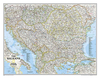
Balkans NGS Classic Wall Map PAPER

The Balkans at 1: 1, 948, 000 on a political wall map from the NGS, size 77 x 59.5cm (30” x 23.5” approx) – paper version, presenting the region their characteristic classic style: countries with a light base and international boundaries picked out in colour and the seas in light blue.Coverage extends from the Adriatic to the Black Sea and from the northern borders of Hungary and Moldova to central Greece. Country names are in their English versions; city names are as used in their countries, accompanied where appropriate by the English equivalent (Beograd/Belgrade). In Greece and the countries using the Cyrillic alphabet all place names are shown in the Latin alphabet. Within Hungary, Romania, and Bulgaria internal administrative boundaries are marked, accompanied by lists
with names of provinces and their capital cities (not for Bulgaria). Within Serbia the map shows the boundary of Vojvodina and in Bosnia-Herzegovina Republika Srpska is marked.The map shows principal road, rail and ferry connections and main international airports. Topography is in indicated by light relief shading with names of main geographical features. Latitude and longitude lines are drawn at 1° intervals.Please note: this map is also available encapsulated.
RIP - This product is no longer available on our network. It was last seen on 25.09.2019

This page now acts as a permanent archive for this product. Add more information using the comments box below to ensure it can still be found by future generations.

Use our search facility to see if it is available from an alternative contributor.
  • External links may include paid for promotion
  • Availability: Out Of Stock
  • Supplier: Stanfords
  • SKU: 9781597754040
Availability: In Stock
£12.99

Product Description

The Balkans at 1: 1, 948, 000 on a political wall map from the NGS, size 77 x 59.5cm (30” x 23.5” approx) – paper version, presenting the region their characteristic classic style: countries with a light base & international boundaries picked out in colour & the seas in light blue. Coverage extends from the Adriatic to the Black Sea & from the northern borders of Hungary & Moldova to central Greece. Country names are in their English versions; city names are as used in their countries, accompanied where appropriate by the English equivalent (Beograd/ Belgrade). In Greece & the countries using the Cyrillic alphabet all place names are shown in the Latin alphabet. Within Hungary, Romania, & Bulgaria internal administrative boundaries are marked, accompanied by lists with names of provinces & their capital cities (not for Bulgaria). Within Serbia the map shows the boundary of Vojvodina & in Bosnia-Herzegovina Republika Srpska is marked. The map shows principal road, rail & ferry connections & main international airports. Topography is in indicated by light relief shading with names of main geographical features. Latitude & longitude lines are drawn at 1° intervals. Please note: this map is also available encapsulated.

Reviews/Comments

Add New

Intelligent Comparison

Oooops!
We couldn't find anything!
Perhaps this product's unique.... Or perhaps we are still looking for comparisons!
Click to bump this page and we'll hurry up.

Price History

Vouchers

No voucher codes found.
Do you know a voucher code for this product or supplier? Add it to Insights for others to use.

Facebook

Jargon Buster

Paper - A thin sheet mainly used for writing. Available in a variety of colours. Made mainly from wood pulp.
Black - A colour which does not emit any colour of the spectrum. Black absorbs all frequencies of the spectrum.
Blue - A primary colour
Wall - A physical barrier between two areas
Colour - The categorised spectrum of light visable to humans
Size - is the measurement of how big an object is in space.
Road - a manmade lane or a path that is used to speed up travel.
Classic - Something that is still like it was originally a high quality standard.
Borders - A line that sometimes can be built up separating off an area, e.g. countries "the welsh boarder"

Supplier Information

Stanfords
Stanfords was established in 1853 and opened their iconic Covent Garden flagship store in 1901. They have become the top retailer of maps, travel books and accessories in the UK and arguably offer the largest selection of maps and travel books worldwide. Famous names such as Captain Robert Falcon Scott, Ranulph Fiennes and Michael Palin have purchased from Stanfords. They now have a shop in Bristol and both stores together with other venues operate a calendar of events including talks, book signings and exhibitions. As a specialist map retailer, the map selection is comprehensive and includes road maps, street maps and walking maps from worldwide destinations, as well as a selection of world atlases and wall maps. Books include travel guides and travel literature. Stanfords also stock globes, from miniatures made of blue marble to magnificent floor-standing globes. The website features a selection of interesting articles on travel topics.
Page Updated: 2023-11-12 20:15:36

Community Generated Product Tags

Oh No! The productWIKI community hasn't generated any tags for this product yet!
Menu