More From Contributor
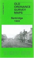
£3.50
Banagher in 1909 in a fascinating series of reproductions of old Ordnance Survey plans in the Alan Godfrey Editions, ideal for anyone interested in the history of their neighbourhood or family. The map is double-sided; the main map covers most of the little town of Banagher, which has connections with both Anthony Trollope & Charlotte Brontë. Features include the Main Street, railway terminus, Bridge Malt House, River Shannon, Banagher Bridge, Cuba Court, Fair Green, Fort Eliza, Crank Malt House, harbour, Birds Isl&, Curraghavarna & Portavolla township, Mullaghakaraun township, etc. On the reverse is part of the adjacent sheet 29.04 extending coverage south to include St Rynagh`s RC church, St Paul`s church, Mountcarteret House, Castle Garden House, Distillery & the ruined Garry castle. About the Alan Godfrey Editions of the 25” OS Series: Selected towns in Great Britain & Ireland are covered by maps showing the extent of urban development in the last decades of the 19th & early 20th century. The plans have been taken from the Ordnance Survey mapping & reprinted at about 15 inches to one mile (1:4, 340). On the reverse most maps have historical notes & many also include extracts from contemporary directories. Most maps cover about one mile (1.6kms) north/south, one & a half miles (2.4kms) across; adjoining sheets can be combined to provide wider coverage.FOR MORE INFORMATION & A COMPLETE LIST OF ALL AVAILABLE TITLES PLEASE CLICK ON THE SERIES LINK. ...
Archived Product
£6.99
Getting what you want can be tricky, especially if you don`t ask in quite the right way. Follow one little monkey`s journey through many emotions as he tries every trick in the book to get hold of his friend`s banana, until he finally hits on the magic word
- please! Using only two words, this is a fantastic introduction to the value of manners & compromise for young children. Packed with humour, colour & exuberance, this is a brilliant observation of toddler behaviour.
...
Archived Product
£10.99
Go bananas with Bananagrams, the addictively entertaining wordplay phenomenon that's launched four award-winning games plus a bestselling book series. The Bananagrams! Calendar delivers fun, fast-paced anagram challenges written by Joe Edley
- the only three-time National Scrabble Champion. Ranging in difficulty from one banana to four bananas, these puzzles are pure joy for crossword lovers & word game junkies.
...
Archived Product
£14.95
Banaras is a city on the banks of the river Ganges. It is the holiest of the seven sacred cities in Hinduism & Jainism, & played an important role in the development of Buddhism. It is regarded as one of the oldest continuously inhabited cities in the world. It is portrayed beautifully through Majumdar`s captivating perspective on different walks around the city. Banaras witnesses thousands of devout Hindus who journey to the banks of the Ganga to wash their sins away. The ghats & the riot of colours only add to the character of this city. Banaras now known as Varanasi is also a major tourist attraction & welcomes thousands from around the world. ...
Archived Product
£15.99
Northern Banat: Szeged
- Timisoara – Arad at 1:200, 000 from Höfer Verlag on an indexed map with present day road & rail networks
...
Archived Product
£2.95
Banbury in 1881 in a fascinating series of reproductions of old Ordnance Survey plans in the Alan Godfrey Editions, ideal for anyone interested in the history of their neighbourhood or family. Selected towns in Great Britain & Ireland are covered by maps showing the extent of urban development in the last decades of the 19th & early 20th century. In this title: two maps for Banbury have been published, showing how the town changed across the years. These detailed maps cover the centre & eastern side of Banbury. Coverage stretches from St Mary's church, the High Street & Dashwood House eastward to Grimsbury, & beyond that open fields & the county boundary. Features include the GWR & LNWR stations, Britannia Works, Oxford Canal, Market Place, Bridge Street, Town Hall, Broad Street, Cherwell Works, corn mill, tweed manufactory. In Grimsbury features include St Leonard's church, Middleton Road, Causeway, West Street, Railway Terrace. The 1881 version is double-sided &

Includes::
part of adjacent sheet 5.12, covering the western part of the town, including Banbury Cross, Horse Fair, South Bar Street, Wood GFreen, Neithrop, Workhouse etc. About the Alan Godfrey Editions of the 25

...
Archived Product
£3.50
Banbury in 1881 in a fascinating series of reproductions of old Ordnance Survey plans in the Alan Godfrey Editions, ideal for anyone interested in the history of their neighbourhood or family. Two maps for Banbury have been published, showing how the town changed across the years. The maps cover the centre & the eastern side of Banbury. Coverage stretches from St Mary`s church, the High Street & Dashwood House eastward to Grimsbury, & beyond that open fields & the county boundary. Features include the GWR & LNWR stations, Britannia Works, Oxford Canal, Market Place, Bridge Street, Town Hall, Broad Street, Cherwell Works, corn mill, tweed manufactory. In Grimsbury features include St Leonard`s church, Middleton Road, Causeway, West Street, Railway Terrace. The 1881 version is double-sided &

Includes::
part of adjacent sheet 5.12, covering the western part of the town, including Banbury Cross, Horse Fair, South Bar Street, Wood GFreen, Neithrop, Workhouse, etc. About the Alan Godfrey Editions of the 25” OS Series: Selected towns in Great Britain & Ireland are covered by maps showing the extent of urban development in the last decades of the 19th & early 20th century. The plans have been taken from the Ordnance Survey mapping & reprinted at about 15 inches to one mile (1:4, 340). On the reverse most maps have historical notes & many also include extracts from contemporary directories. Most maps cover about one mile (1.6kms) north/south, one & a half miles (2.4kms) across; adjoining sheets can be combined to provide wider coverage.FOR MORE INFORMATION & A COMPLETE LIST OF ALL AVAILABLE TITLES PLEASE CLICK ON THE SERIES LINK.

...
Archived Product
£3.50
Banbury in 1900 in a fascinating series of reproductions of old Ordnance Survey plans in the Alan Godfrey Editions, ideal for anyone interested in the history of their neighbourhood or family. Two maps for Banbury have been published, showing how the town changed across the years. The maps cover the centre & the eastern side of Banbury. Coverage stretches from St Mary`s church, the High Street & Dashwood House eastward to Grimsbury, & beyond that open fields & the county boundary. Features include the GWR & LNWR stations, Britannia Works, Oxford Canal, Market Place, Bridge Street, Town Hall, Broad Street, Cherwell Works, corn mill, tweed manufactory. In Grimsbury features include St Leonard`s church, Middleton Road, Causeway, West Street, Railway Terrace. The 1881 version is double-sided &

Includes::
part of adjacent sheet 5.12, covering the western part of the town, including Banbury Cross, Horse Fair, South Bar Street, Wood GFreen, Neithrop, Workhouse, etc. About the Alan Godfrey Editions of the 25” OS Series: Selected towns in Great Britain & Ireland are covered by maps showing the extent of urban development in the last decades of the 19th & early 20th century. The plans have been taken from the Ordnance Survey mapping & reprinted at about 15 inches to one mile (1:4, 340). On the reverse most maps have historical notes & many also include extracts from contemporary directories. Most maps cover about one mile (1.6kms) north/south, one & a half miles (2.4kms) across; adjoining sheets can be combined to provide wider coverage.FOR MORE INFORMATION & A COMPLETE LIST OF ALL AVAILABLE TITLES PLEASE CLICK ON THE SERIES LINK.

...
Archived Product
£6.39
A detailed topographic map of Banbury, Bicester & Chipping Norton from the Ordnance Survey Explorer series, covering Brackley. Edition A1; Publication date February 2006 About this series: These highly detailed maps show all the administrative boundaries, settlements as small as isolated farms, the road network down to unfenced roads & country tracks, & field boundaries (hedges & drystone walls) which make navigation across the countryside much easier. Steep gradients on roads are indicated. Various landmarks, e.g. powerlines, archaeological sites, windmills, churches & lighthouses are shown & additional graphics indicate natural terrain features such as cliffs, scree, mud & vegetation variations. The contour interval is 5 metres in the lower parts of the country & 10 metres in the uplands, & spot heights are marked. Each map covers an area of 30 x 20km (i.e. approx. 19 x 12 miles), with some double-sided maps covering more, as indicated in the individual descriptions. The maps are fully GPS compatible, with the National Grid shown at 1km intervals & latitude & longitude indicated by margin ticks at 1'. The Explorer series has replaced the earlier, green-cover Pathfinder maps. The Explorer series is now complete & covers all of Engl&, Wales & Scotl&. Some sheets for popular areas like the National Parks are still branded as Outdoor Leisure (OL) maps, but are now included in this series as the cartography is the same as that in the Explorer Maps. The Explorer maps offer a substantial improvement on the Pathfinder series, with greater use of colour, larger area per map, & stronger emphasis on information for ramblers & tourists. This series is ideal for walking & other outdoor pursuits & each map shows a large amount of information for ramblers & tourists. Public rights of way are shown (except in Scotland), together with other routes with public access: National Trails & Recreational Paths, permitted paths & bridleways, & selected cycle routes. Open access land created under the Countryside & Rights of Way Act 2000 is marked. Tourist information

Includes::
caravan & camp sites, Park & Ride locations, recreation/leisure/sport centres, museums, historic buildings, English Heritage & National Trust sites, rural pubs, etc. The map legend is in English only, except for the tourist information content which is also in French & German.

...
Archived Product
£14.99
Banbury, Bicester, Chipping Norton & Brackley area on a detailed topographic & GPS compatible map No. 191, waterproof version, from the Ordnance Survey’s 1:25, 000 Explorer series.MOBILE DOWNLOADS: this title & all the other OS Explorer maps include a code for downloading after purchase the digital version onto your smartphone or tablet for viewing on the OS smartphone app.OS EXPLORER SERIES: to see the list of all the titles in the OS Explorer series, both paper & waterproof versions, please click on the series link. The Explorer series, Ordnance Survey’s most detailed maps recommended for anyone enjoying outdoor activities, provides topographic coverage of Great Britain at 1:25, 000 on GPS compatible maps with hiking trails, cycling routes & extensive tourist information. Each printed map is available either on paper or as a waterproof & tear-resistant OS Active Map, as indicated in its title. Britain’s National Parks & other areas of particular tourist interest are presented on often double-sided OL (Outdoor Leisure) maps, whilst most standard format Explorers cover an area of 30 x 20km (approx. 19 x 12 miles). All three versions (paper, waterproof & digital) are the same & provide plenty of recreational & tourist information, indicating the traditional public right of way paths (except in Scotland where different laws apply), including bridleways & byways. National Trails & other long-distance paths are marked, as well as permissive footpaths or bridleways & on-road or traffic-free cycle routes with, where appropriate, their National/ Regional Cycle Network numbers. Boundaries of access land are clearly marked. A wide range of symbols provides additional tourist information, highlighting camping & caravanning sites, information offices & visitors’ centres, parking & picnicking places, country pubs, sport & recreational facilities including cycle hire locations & mountain biking trails, historic buildings & museums, etc. Exceptionally clear presentation of the landscape is provided by contours at 5m or in the uplands at 10m intervals, with additional spot heights plus colouring and/or graphics for different types of woodlands, orchards, heath, marshl&, scree or boulders, & other topographic features. For GPS users the maps have British National Grid lines at 1km intervals, with latitude & longitude given by margin ticks at 1`. Clearly laid out map legend

Includes::
French & German translations for the tourist information symbols.

...
Archived Product

Banbridge 1903

Banbridge in 1903 in a fascinating series of reproductions of old Ordnance Survey plans in the Alan Godfrey Editions, ideal for anyone interested in the history of their neighbourhood or family. The map is double-sided. The main map covers the centre and west of the town. Features include Newry Street, most of Bridge Street, railway station, Edenderry Works, Workhouse, Downshire Arms Hotel, Court House, Brookfield and Weaving Factory, and countryside westward to Grove Hill and Ringsend. On the reverse is part of the adjacent sheet 27.14, covering Holy Trinity church, St Patrick`s RC church, weaving factories on the Bann, Church Square, Ballydown Bleach Works, etc.About the Alan Godfrey Editions of the 25” OS Series:Selected towns in Great Britain and Ireland are covered by
maps showing the extent of urban development in the last decades of the 19th and early 20th century. The plans have been taken from the Ordnance Survey mapping and reprinted at about 15 inches to one mile (1:4, 340). On the reverse most maps have historical notes and many also include extracts from contemporary directories. Most maps cover about one mile (1.6kms) north/south, one and a half miles (2.4kms) across; adjoining sheets can be combined to provide wider coverage.FOR MORE INFORMATION AND A COMPLETE LIST OF ALL AVAILABLE TITLES PLEASE CLICK ON THE SERIES LINK.
RIP - This product is no longer available on our network. It was last seen on 25.09.2019

This page now acts as a permanent archive for this product. Add more information using the comments box below to ensure it can still be found by future generations.

Use our search facility to see if it is available from an alternative contributor.
  • Availability: Out Of Stock
  • Supplier: Stanfords
  • SKU: 9781847846365
Availability: In Stock
£3.50

Product Description

Banbridge in 1903 in a fascinating series of reproductions of old Ordnance Survey plans in the Alan Godfrey Editions, ideal for anyone interested in the history of their neighbourhood or family. The map is double-sided. The main map covers the centre & west of the town. Features include Newry Street, most of Bridge Street, railway station, Edenderry Works, Workhouse, Downshire Arms Hotel, Court House, Brookfield & Weaving Factory, & countryside westward to Grove Hill & Ringsend. On the reverse is part of the adjacent sheet 27.14, covering Holy Trinity church, St Patrick`s RC church, weaving factories on the Bann, Church Square, Ballydown Bleach Works, etc. About the Alan Godfrey Editions of the 25” OS Series: Selected towns in Great Britain & Ireland are covered by maps showing the extent of urban development in the last decades of the 19th & early 20th century. The plans have been taken from the Ordnance Survey mapping & reprinted at about 15 inches to one mile (1:4, 340). On the reverse most maps have historical notes & many also include extracts from contemporary directories. Most maps cover about one mile (1.6kms) north/south, one & a half miles (2.4kms) across; adjoining sheets can be combined to provide wider coverage.FOR MORE INFORMATION & A COMPLETE LIST OF ALL AVAILABLE TITLES PLEASE CLICK ON THE SERIES LINK.

Reviews/Comments

Add New

Intelligent Comparison

Oooops!
We couldn't find anything!
Perhaps this product's unique.... Or perhaps we are still looking for comparisons!
Click to bump this page and we'll hurry up.

Price History

Vouchers

No voucher codes found.
Do you know a voucher code for this product or supplier? Add it to Insights for others to use.

Facebook

Jargon Buster

Contemporary - Modern era design
Contemporary - A design reference to indicate post war modern design
Hotel - An establishment which provides lodging for a fee
History - Anything that happens in the past. An acedemic subject.
Contemporary - An object that is living in the same time.
Ideal - Something that satisfies a perfect criteria.
Family - A group of people that live together made up from parents and children.

Supplier Information

Stanfords
Stanfords was established in 1853 and opened their iconic Covent Garden flagship store in 1901. They have become the top retailer of maps, travel books and accessories in the UK and arguably offer the largest selection of maps and travel books worldwide. Famous names such as Captain Robert Falcon Scott, Ranulph Fiennes and Michael Palin have purchased from Stanfords. They now have a shop in Bristol and both stores together with other venues operate a calendar of events including talks, book signings and exhibitions. As a specialist map retailer, the map selection is comprehensive and includes road maps, street maps and walking maps from worldwide destinations, as well as a selection of world atlases and wall maps. Books include travel guides and travel literature. Stanfords also stock globes, from miniatures made of blue marble to magnificent floor-standing globes. The website features a selection of interesting articles on travel topics.
Page Updated: 2023-11-12 20:15:36

Community Generated Product Tags

Oh No! The productWIKI community hasn't generated any tags for this product yet!
Menu