More From Contributor

£24.95
Updated Edition: More Pages! More Pics! More words! Incl Banksy`s October 2013 NY residency ` Better Out Than In`. The single best collection of photographs of Banksy`s street work. Period. You Are An Acceptable Level of Threat concentrates on this singular artist`s iconic imagery, spanning the late `90s up until the end of 2011. The locations are from around the world (predominantly the UK, US & Europe), & many images have never been seen before. When Banksy started out painting, the political landscape was bleak. Fortunately now, it`s ten times worse. As Banksy`s cheerfully aggressive political work becomes ever more relevant, this comprehensive tome sets about presenting his art in the context of the era he was responding to. ...
Archived Product
£19.95
The single best collection of photographs of Banksy's street work. Period. You Are An Acceptable Level of Threat concentrates on this singular artist's iconic imagery, spanning the late '90s up until the end of 2011. The locations are from around the world (predominantly the UK, US & Europe), & many images have never been seen before. When Banksy started out painting, the political landscape was bleak. Fortunately now, it's ten times worse. As Banksy's cheerfully aggressive political work becomes ever more relevant, this comprehensive tome sets about presenting his art in the context of the era he was responding to. ...
Archived Product
£8.99
For someone who shuns the limelight so completely that he conceals his name, never shows his face & gives interviews only by email, Banksy is remarkably famous. From his beginnings as a Bristol graffiti artist, his artwork is now sold at auction for six-figure sums & hangs on celebrities` walls. The appearance of a new Banksy is national news, his documentary Exit Through the Gift Shop was Oscar-nominated & people queue for hours to see his latest exhibition. Now more National Treasure than edgy outsider, who is Banksy & how did he become what he is today? In the first attempt to tell the full story of Banksy`s life & career, Will Ellsworth-Jones pieces together a picture of his world & unpicks its contradictions. Whether art or vandalism, anti-establishment or sell-out, Banksy & his work have become a cultural phenomenon & the question ` Who is Banksy?` is as much about his career as it is `the man behind the wall`. ` Britain`s unlikeliest national treasure` Independent `A fascinating portrait that elicits admiration for a man who, despite his increasingly unconvincing efforts to retain some shred of his vandal status, has had an undeniable impact on art` The Times ...
Archived Product
£20.00
For someone who shuns the limelight so completely that he conceals his name, never shows his face & gives interviews only by email, Banksy is remarkably famous. From his beginnings as a Bristol graffiti artist, his artwork is now sold at auction for six-figure sums & hangs on celebrities' walls. The appearance of a new Banksy is national news, his documentary Exit Through the Gift Shop was Oscar-nominated & people queue for hours to see his latest exhibition. Now more National Treasure than edgy outsider, who is Banksy & how did he become what he is today? In the first attempt to tell the full story of Banksy's life & career, Will Ellsworth-Jones pieces together a picture of his world & unpicks its contradictions. Whether art or vandalism, anti-establishment or sell-out, Banksy & his work have become a cultural phenomenon & the question ' Who is Banksy?' is as much about his career as it is 'the man behind the wall'. ' Britain's unlikeliest national treasure' Independent 'A fascinating portrait that elicits admiration for a man who, despite his increasingly unconvincing efforts to retain some shred of his vandal status, has had an undeniable impact on art' The Times ...
Archived Product
£2.95
Bannockburn in 1896 in a fascinating series of reproductions of old Ordnance Survey plans in the Alan Godfrey Editions, ideal for anyone interested in the history of their neighbourhood or family. The map covers the village of Bannockburn, south-east of Stirling, extending westward to Milton & southward to Muir of Bannockburn. Features include Muiralehouse, Cat Craig, Newmarket, Stein's Square, Caledonian Railway with Bannockburn station, Lower Greenyards, infectious diseases hospital, Town Hall, Greenyards Colliery, Skeochmill, Woollen Factory, Royal George Carpet Factory, Balquhidderock, etc. About the Alan Godfrey Editions of the 25 ...
Archived Product
£5.99
Street Plan of Bansko at 1:5, 000 with on the reverse a panorama map of the local mountains showing ski runs & related facilities. The plan is annotated with symbols highlighting locations of numerous hotels & various facilities including information centre, cash dispensers, petrol stations & car repairs, etc. Streets show selected house numbers for easier identification of addresses. Names of larger streets & most hotels are given in both Cyrillic & Latin alphabet. Map legend

Includes::
English. Street index is in Cyrillic only. The map is accompanied by a very extensive bilingual list of hotels & other accommodation with phone numbers & web addresses, plus numerous advertisements illustrating many entries. On the reverse is a panorama map showing ski runs on the Pirin Mountains, graded according to the degree of difficulty, plus cable car lines, ski & chair lifts, equipment hire points, restaurants, etc. Also provided is an extensive gazetteer of various facilities & services within Bansko & notes about the city & its region. All the information is tri-lingual: Bulgarian, English & German.

...
Archived Product
£395.00
The 1930s saw the rise of hand built model racecars, known as spindizzies or tether cars. Constructed using original blueprints our Bantam Midget model resembles the original down to the smallest detail. Featuring traditional dye stamped body parts in aluminum, brass & polished mahogany wood, this Bantam model contains a detailed engine replication. More than just a toy, this model car is an ideal gift for an avid model car collector or as a decoration to give any room a unique & distinctive twist. If we do not have this item in stock we will order it for you from our supplier. Delivery generally takes 3 weeks within the UK. For overseas delivery queries please email sales@stanfords.co.uk ...
Archived Product
£12.99
Topographic survey of Catalonia at 1:25, 000 from the Institut Cartogràfic i Geològic de Catalunya, an attractive alternative to Spain’s national topographic survey at this scale, offering a much larger area per sheet with extensive tourist information & vivid presentation of vegetation & land use. These large, detailed maps have contours at 10m intervals enhanced by hill shading & fine colouring and/or graphics to portray of vegetation or land use (different types of woodlands, marshl&, vineyards, crops, etc). An overprint highlights waymarked local & long-distance GR footpaths plus CT cycling routes. Also highlighted are picturesque locations such as villages, isolated buildings or natural features. A very wide range of symbols indicate various facilities, places of interest & recreational sites: tourist information centres, campsites & other rural accommodation, cultural heritage, vineries, wildlife observation areas, viewpoints & beauty spots, sites for recreational pursuits including horse riding, water sports, paragliding, etc The maps are divided by the publishers into three types: Administrative Units, Natural Protected Areas, & Geographical Areas, as shown on our grid for this series. Coverage by each sheet varies; most maps present an area of 30 x 23km (19 x 14km approx). The maps have a 1km UTM grid, with latitude & longitude values shown for the map corners. Excellently presented topographic map legend is in Catalan only but the legend for the tourist information & the road network

Includes::
English. To see the list of all the titles in this series please click on the series link.

...
Archived Product
£6.95
Topographic coverage of mainland Spain at 1:50, 000 in the MTN50 (Mapa Topográfico Nacional) series from the Centro Nacional de Información Geografica, the country’s civilian survey organization. The maps have contours at 20m intervals, enhanced by relief shading, plus colouring and/or graphics to show different types of terrain, vegetation or land use. Boundaries of national parks & other protected areas are marked. In addition to all the usual information featured on topographic mapping at this scale, detailed presentation of the road & rail networks, rural tracks & paths, etc, the maps also show campsites & mountain refuges. On more recent editions some GRs, the official long-distance hiking routes, are also marked (although not as clearly as on hiking maps from other publishers). Each map covers 29.5x 18.5 km (with adjustments in the border or coastal areas). The maps have a 1-km UTM grid, plus margin ticks for latitude & longitude at 1` intervals. Map legend is in Spanish only.HOW TO CHOOSE THE RIGHT 50K MAP: all the titles in CNIG’s 200K Provincial Road Maps series at 1:200, 000 are overprinted with the grid for the 1:50, 000 maps & can be used to see the area covered by each 50K title. TO SEE THE LIST OF TITLES IN THIS SERIES PLEASE CLICK ON THE SERIES LINK.PLEASE NOTE
- MAP TITLES: the grids shown on our website serve both the civilian & the military 1:50, 000 topographic series. Although the areas covered by maps in both series are identical (apart from some border or coastal sheets), occasionally map titles differ – only one title is shown on the grid, usually the military one. In Galicia, the Basque country & in the Catalan speaking areas the tendency now is to use local place names rather than the often better known Castilian ones. Where possible, both versions are included in our titles. Map titles listed on our website are based on information received by us at the time of publication, but sometimes maps arrive showing a completely different title! As long as the map number is as ordered, the correct map has been supplied.
...
Archived Product
£12.99
Topographic survey of France at 1:25, 000 in IGN`s excellent TOP25 / Série Bleue series. All the maps are GPS compatible, with a 1km UTM grid plus latitude & longitude lines at 5’ intervals. Contours are at 5m intervals except for mountainous areas where the maps have contours at 10m intervals, vividly enhanced by hill shading & graphics for rocky terrain. Colouring with graphics indicates different types of vegetation or land use (deciduous or coniferous forests, moors, orchards, vineyards, etc). PLEASE NOTE: coverage of France at this scale is currently being revised – the format & the presentation of each title are indicated by the letters at the end of its Sheet Reference number (e.g. 0416ET, 3531ETR, 1923SB, etc.)MAPS WITH FULL TOURIST OVERPRINT & AN ENGLISH MAP LEGEND: all TOP25 maps & the SB editions of Série Bleue have an overprint highlighting waymarked walking trails including long-distance GR routes &, where appropriate, ski routes. Symbols indicate campsites, gîtes d’etape, refuges, equestrian centres & other recreational facilities or sites, tourist information centres, cultural heritage, etc. Towns & locations of particular interest are highlighted.- ET or OT = single-sided TOP25 map covering approx. 29x 21 km / 18x 13 miles.- ETR or OTR = waterproof & tear resistant TOP25 map covering the same area as the corresponding ET or OT number, but double-sided, printed on a smaller size sheet with a good overlap between the sides.- SB = Série Bleue map with full tourist overprint; these maps, first introduced in summer 2014, each cover approx. 29x 24km / 18x 15 miles.SÉRIE BLEUE maps with numbers ending in E (Est) or O (Ouest): most editions now indicate the GR routes, but do not show any other tourist information. Map legend is in French only. Each map covers approx. 14x 20km / 9x 12 miles. ...
Archived Product

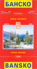
Bansko (with Pirin National Park)

Street Plan of Bansko at 1:5, 000 with on the reverse a panorama map of the local mountains showing ski runs and related facilities. The plan is annotated with symbols highlighting locations of numerous hotels and various facilities including information centre, cash dispensers, petrol stations and car repairs, etc. Streets show selected house numbers for easier identification of addresses.Names of larger streets and most hotels are given in both Cyrillic and Latin alphabet. Map legend includes English. Street index is in Cyrillic only. The map is accompanied by a very extensive bilingual list of hotels and other accommodation with phone numbers and web addresses, plus numerous advertisements illustrating many entries.Approximately a third of the reverse side is taken by a contoured
hiking map of the Pirin National Park at 1:60, 000, overprinted with 13 waymarked hiking routes, each accompanied by brief notes. Also shown are cable car lines and lifts, huts and shelters, interesting trees or rock formations, caves and other places of interest. The map has no geographical coordinates. All place names are given in both Cyrillic and Latin alphabet.Also provided is an extensive gazetteer of various facilities and services within Bansko and notes about the city and its region. All the information is tri-lingual: Bulgarian, English and German.
RIP - This product is no longer available on our network. It was last seen on 25.09.2019

This page now acts as a permanent archive for this product. Add more information using the comments box below to ensure it can still be found by future generations.

Use our search facility to see if it is available from an alternative contributor.
  • Availability: Out Of Stock
  • Supplier: Stanfords
  • SKU: X183589
Availability: In Stock
£5.99

Product Description

Street Plan of Bansko at 1:5, 000 with on the reverse a panorama map of the local mountains showing ski runs & related facilities. The plan is annotated with symbols highlighting locations of numerous hotels & various facilities including information centre, cash dispensers, petrol stations & car repairs, etc. Streets show selected house numbers for easier identification of addresses. Names of larger streets & most hotels are given in both Cyrillic & Latin alphabet. Map legend

Includes::
English. Street index is in Cyrillic only. The map is accompanied by a very extensive bilingual list of hotels & other accommodation with phone numbers & web addresses, plus numerous advertisements illustrating many entries. Approximately a third of the reverse side is taken by a contoured hiking map of the Pirin National Park at 1:60, 000, overprinted with 13 waymarked hiking routes, each accompanied by brief notes. Also shown are cable car lines & lifts, huts & shelters, interesting trees or rock formations, caves & other places of interest. The map has no geographical coordinates. All place names are given in both Cyrillic & Latin alphabet. Also provided is an extensive gazetteer of various facilities & services within Bansko & notes about the city & its region. All the information is tri-lingual: Bulgarian, English & German.

Reviews/Comments

Add New

Intelligent Comparison

Oooops!
We couldn't find anything!
Perhaps this product's unique.... Or perhaps we are still looking for comparisons!
Click to bump this page and we'll hurry up.

Price History

Vouchers

No voucher codes found.
Do you know a voucher code for this product or supplier? Add it to Insights for others to use.

Facebook

Jargon Buster

Hiking - An outdoor activity envolving walking in nature
phone - Short for telephone. A device that transmits sound allowing point to point communication over long distances
Cable - A series of wires bonded to form a single thread
Car - A machine used for transport which runs on roads
Accommodation - A room in which someone can live in, for example in a hotel

Supplier Information

Stanfords
Stanfords was established in 1853 and opened their iconic Covent Garden flagship store in 1901. They have become the top retailer of maps, travel books and accessories in the UK and arguably offer the largest selection of maps and travel books worldwide. Famous names such as Captain Robert Falcon Scott, Ranulph Fiennes and Michael Palin have purchased from Stanfords. They now have a shop in Bristol and both stores together with other venues operate a calendar of events including talks, book signings and exhibitions. As a specialist map retailer, the map selection is comprehensive and includes road maps, street maps and walking maps from worldwide destinations, as well as a selection of world atlases and wall maps. Books include travel guides and travel literature. Stanfords also stock globes, from miniatures made of blue marble to magnificent floor-standing globes. The website features a selection of interesting articles on travel topics.
Page Updated: 2023-11-12 20:15:36

Community Generated Product Tags

97816016045 (2 people tagged the product this way)
Menu