More From Contributor

£5.99
The latest from venerable storyteller & brilliant artist Laurent de Brunhoff has Babar`s family on a world tour! They visit a number of countries around the globe. First stop is Italy where they learn to say ” Buon giorno! Hello!” After that, it`s off to Germany, Spain, Russia, India, Japan, & Thail&. Then Mexico, the Southwest United States, Egypt, Antarctica, &, of course, France. In each place the children learn to say ”hello” & discover a bit about the local culture. BABAR`S WORLD TOUR is a wonderful way to introduce children to an international array of cities & customs & will be fun for globe trotters & armchair travelers of all ages! ...
Archived Product
£6.95
Topographic coverage of mainland Spain at 1:50, 000 in the MTN50 (Mapa Topográfico Nacional) series from the Centro Nacional de Información Geografica, the country’s civilian survey organization. The maps have contours at 20m intervals, enhanced by relief shading, plus colouring and/or graphics to show different types of terrain, vegetation or land use. Boundaries of national parks & other protected areas are marked. In addition to all the usual information featured on topographic mapping at this scale, detailed presentation of the road & rail networks, rural tracks & paths, etc, the maps also show campsites & mountain refuges. On more recent editions some GRs, the official long-distance hiking routes, are also marked (although not as clearly as on hiking maps from other publishers). Each map covers 29.5x 18.5 km (with adjustments in the border or coastal areas). The maps have a 1-km UTM grid, plus margin ticks for latitude & longitude at 1` intervals. Map legend is in Spanish only.HOW TO CHOOSE THE RIGHT 50K MAP: all the titles in CNIG’s 200K Provincial Road Maps series at 1:200, 000 are overprinted with the grid for the 1:50, 000 maps & can be used to see the area covered by each 50K title. TO SEE THE LIST OF TITLES IN THIS SERIES PLEASE CLICK ON THE SERIES LINK.PLEASE NOTE
- MAP TITLES: the grids shown on our website serve both the civilian & the military 1:50, 000 topographic series. Although the areas covered by maps in both series are identical (apart from some border or coastal sheets), occasionally map titles differ – only one title is shown on the grid, usually the military one. In Galicia, the Basque country & in the Catalan speaking areas the tendency now is to use local place names rather than the often better known Castilian ones. Where possible, both versions are included in our titles. Map titles listed on our website are based on information received by us at the time of publication, but sometimes maps arrive showing a completely different title! As long as the map number is as ordered, the correct map has been supplied.
...
Archived Product
£6.50
Topographic coverage of mainland Spain at 1:25, 000 published by the Centro Nacional de Información Geograficá, the country’s civilian survey organization. The maps have contours at 10m intervals & colouring and/or graphics to show different types of vegetation or land use. Boundaries of national parks & other protected areas are marked. In addition to all the usual information shown on topographic maps at this scale, detailed presentation of the road & rail networks, rural tracks & paths, etc, the maps also show campsites. The maps have a 1-km UTM grid, with margin ticks for latitude & longitude at 1` intervals. Map legend is in Spanish only.PLEASE NOTE: our grid for the whole of Spain is in preparation
- in the meantime, for areas other than those shown on the attached grid please use CNIG’s topographic survey at 1:50, 000 by searching for ‘SI00000832’. Each 25K map covers one quarter of the corresponding 50K map, with the numbering system: I = NW quarter, II = NE quarter, III = SW quarter & IV = SE quarter. CNIG maps in the Provincial Road Maps series at 1:200, 000 are overprinted with the grid for the 1:50, 000 survey & can be used to see the area covered by each 50K or 25K title in more detail. To see the list of titles in this series please click on the series grid
- for map numbers not yet listed on our website please contact us by email.

...
Archived Product
£20.00
From the best-selling French author of ” Ripailles”, ” Rotis” & ”365 Good Reasons to Sit Down to Eat” comes this celebration of all things grilled, seared & baked
- Barbecue. With over 140 irresistible recipes including tender cutlets, succulent roasts & ribs, as well as a selection of accompaniments, from minted grilled vegetables to a decadent baked camembert, there`s a recipe for every barbecue get-together. Written in his well-known eccentric style, Stephane never fails to entertain, & his passion for barbecuing is highly contagious. Key points: this book features more than just traditional barbecue recipes; the recipes range from seafood, meat & poultry to side dishes, baked cheeses & even fruit; Reynaud also provides a chapter of sauces & marinades to dress up any barbecue dish & boost flavour; &, this book is entertaining with Reynaud`s trademark wit, quirky illustrations & striking photography by Marie-Pierre Morel.
...
Archived Product
£7.99
An account of the first source-to-sea descent of Siberia's 4, 400km Amur River, known in China as the Black Dragon. After wading upstream for five days, the two adventurers began their epic four-month journey, knowing virtually nothing about the region they were travelling through. Although facing the possibility of guns, gunboats & arrest at every turn, the pair find a generous, warm-hearted people with a wicked sense of humour & an unhealthy predilection for poetry, pigfat & homemade vodka. ...
Archived Product
£12.99
Map No. 1324, Barberine, in the topographic survey of Switzerland at 1:25, 000 from Bundesamt für Landestopographie (swisstopo), covering the whole country on 247 small format sheets, with special larger maps published for popular regions including some titles now available in hiking versions. Highly regarded for their superb use of graphic relief & hill shading, the maps give an almost 3-D picture of Switzerland`s mountainous terrain. Contours are at 10 m intervals, with 20m intervals in the mountainous areas. All the maps have a 1-km grid for Swiss national coordinates (datum CH 1903). * Small format sheets (Nos. 1011
- 1374)* Map legend in the language of the area covered by the map. Additional margin ticks show latitude & longitude in steps of 2`. The area covered by each map is 17 x 12 km (11 x 7 miles approx). * Special larger sheets (Nos. from 2501 onwards) – STANDARD editions:* No map legend is included but a separate leaflet can be provided instead. The area covered by each map is 25 x 17 km (15 x 11 miles approx).* Special larger sheets (Nos. from 2501 onwards) – HIKING editions:* An overprint highlights hiking, mountain & alpine paths, including regional & national long-distance trails. The maps also show bus routes with bus stops, plus inns in remote locations. The area covered by each map is 25 x 17 km (15 x 11 miles approx).
...
Archived Product
£29.99
Map No. 2530, Barberton, in South Africa’s official topographic survey at 1:250, 000 from the country’s national survey organization, the Chief Directorate of Surveys & Mapping. The maps have altitude colouring & contours at 50m or 100m intervals, depending on the map edition, plus spot heights. Deserts, marshes, dry pans, perennial & seasonal water features, etc, as well as protected areas are shown. The maps present the country’s road & rail networks & include the usual information expected on topographic mapping at this scale, although in more rapidly developing areas road information may not necessarily be up to date. Also indicated are magisterial district & provincial boundaries. Latitude & longitude values are shown in the margins at 5` intervals together with South African grid co-ordinates. Typically, each sheet covers an area of one degree of latitude & two degrees of longitude. The projection used is Gauss Conformal. The legend is in English & Afrikaans. ...
Archived Product
£12.99
Topographic survey of France at 1:25, 000 in IGN`s excellent TOP25 / Série Bleue series. All the maps are GPS compatible, with a 1km UTM grid plus latitude & longitude lines at 5’ intervals. Contours are at 5m intervals except for mountainous areas where the maps have contours at 10m intervals, vividly enhanced by hill shading & graphics for rocky terrain. Colouring with graphics indicates different types of vegetation or land use (deciduous or coniferous forests, moors, orchards, vineyards, etc). PLEASE NOTE: coverage of France at this scale is currently being revised – the format & the presentation of each title are indicated by the letters at the end of its Sheet Reference number (e.g. 0416ET, 3531ETR, 1923SB, etc.)MAPS WITH FULL TOURIST OVERPRINT & AN ENGLISH MAP LEGEND: all TOP25 maps & the SB editions of Série Bleue have an overprint highlighting waymarked walking trails including long-distance GR routes &, where appropriate, ski routes. Symbols indicate campsites, gîtes d’etape, refuges, equestrian centres & other recreational facilities or sites, tourist information centres, cultural heritage, etc. Towns & locations of particular interest are highlighted.- ET or OT = single-sided TOP25 map covering approx. 29x 21 km / 18x 13 miles.- ETR or OTR = waterproof & tear resistant TOP25 map covering the same area as the corresponding ET or OT number, but double-sided, printed on a smaller size sheet with a good overlap between the sides.- SB = Série Bleue map with full tourist overprint; these maps, first introduced in summer 2014, each cover approx. 29x 24km / 18x 15 miles.SÉRIE BLEUE maps with numbers ending in E (Est) or O (Ouest): most editions now indicate the GR routes, but do not show any other tourist information. Map legend is in French only. Each map covers approx. 14x 20km / 9x 12 miles. ...
Archived Product
£14.99
MONUmini is an iconic architectural model kit; a perfect memento, perfect present for an architecture student or a gift for any design enthusiast. The model kit

Includes::
a sheet of etched stainless steel pieces, which fold & lock together to create the miniature structure. The kit also

Includes::
step-by-step assembly instructions & a short building history which is all packed into an attractive envelope making them a great little (easy-to-post!) souvenir. Constructed in 1970`s, The Barbican Towers are prominent examples of British brutalist architecture & visually notable in London’s Skyline. Contents: metal model, instructions, building history
Materials: stainless steel, paper This is not a toy
- the product contains sharp edges & is not suitable for children.


...
Archived Product

Barbecue Bible The Revisied Ed

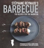
Redesigned inside and out for its 10th anniversary, ”The Barbecue! Bible” now includes full-colour photographs illustrating food preparation, grilling techniques, ingredients, and of course those irresistible finished dishes. A new section has been added with answers to the most frequently asked grilling questions, plus Steven`s proven tips, quick solutions to common mistakes, and more.And then there`s the literal meat of the book: more than 500 of the very best barbecue recipes, inventive, delicious, unexpected, easy-to-make, and guaranteed to capture great grill flavours from around the world. Add in the full-colour, and it`s a true treasure.
RIP - This product is no longer available on our network. It was last seen on 25.09.2019

This page now acts as a permanent archive for this product. Add more information using the comments box below to ensure it can still be found by future generations.

Use our search facility to see if it is available from an alternative contributor.
  • Availability: Out Of Stock
  • Supplier: Stanfords
  • SKU: 9780761149439
Availability: In Stock
£16.99

Product Description

Redesigned inside & out for its 10th anniversary, ” The Barbecue! Bible” now

Includes::
full-colour photographs illustrating food preparation, grilling techniques, ingredients, & of course those irresistible finished dishes. A new section has been added with answers to the most frequently asked grilling questions, plus Steven`s proven tips, quick solutions to common mistakes, & more. And then there`s the literal meat of the book: more than 500 of the very best barbecue recipes, inventive, delicious, unexpected, easy-to-make, & guaranteed to capture great grill flavours from around the world. Add in the full-colour, & it`s a true treasure.

Reviews/Comments

Add New

Intelligent Comparison

Oooops!
We couldn't find anything!
Perhaps this product's unique.... Or perhaps we are still looking for comparisons!
Click to bump this page and we'll hurry up.

Price History

Vouchers

No voucher codes found.
Do you know a voucher code for this product or supplier? Add it to Insights for others to use.

Facebook

Jargon Buster

World - A physical grouping, commonly used to describe earth and everything associated with ti
Colour - The categorised spectrum of light visable to humans
Quick - Something that is fast

Supplier Information

Stanfords
Stanfords was established in 1853 and opened their iconic Covent Garden flagship store in 1901. They have become the top retailer of maps, travel books and accessories in the UK and arguably offer the largest selection of maps and travel books worldwide. Famous names such as Captain Robert Falcon Scott, Ranulph Fiennes and Michael Palin have purchased from Stanfords. They now have a shop in Bristol and both stores together with other venues operate a calendar of events including talks, book signings and exhibitions. As a specialist map retailer, the map selection is comprehensive and includes road maps, street maps and walking maps from worldwide destinations, as well as a selection of world atlases and wall maps. Books include travel guides and travel literature. Stanfords also stock globes, from miniatures made of blue marble to magnificent floor-standing globes. The website features a selection of interesting articles on travel topics.
Page Updated: 2023-11-12 20:15:36

Community Generated Product Tags

Oh No! The productWIKI community hasn't generated any tags for this product yet!
Menu