More From Contributor
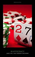
£8.99
Vesna Maric left Bosnia the beginning of the war, at the age of 16, on a convoy of coaches carrying refugees to Penrith, in the north of Engl&. ” Bluebird” is Vesna`s funny, vivid & immensely readable memoir of the experience, from the beginning of the war through to her eventual return to Bosnia, years later. Unlike many books on Bosnia, & refugees in general, ” Bluebird” is never self-pitying, never grave. It`s refreshing to read an account of these experiences filtered through the eyes of a teenager with attitude
- written with brilliant comic timing, & a great storytelling gift.
...
Archived Product
£4.99
The Bluebird Foldable Shopping Bag, comes as a compact & colourful pouch in the shape of an Bluebird & unfolds into a tote bag featuring a delicate decorative print. Very lightweight, the little Bluebird can fit any handbag & be ready to use as an alternative to a plastic bag. The Bluebird Foldable Shopping Bag is ideal for when you pop out to get your lunch or a few items from the shops. ...
Archived Product
£7.99
When it comes to law & order, East Texas plays by its own rules
- a fact that Darren Mathews, a black Texas Ranger working the
...
Archived Product
£8.99
Hurricanes & storms strike New Orleans & Mumbai; flooding causes devastation in England & Mozambique; droughts occur in Australia & Darfur... Further substantial climate change is unavoidable & the risks to the natural world, the economy & our everyday lives are immense. Here Lord Stern, a world leading authority on climate change, confronts urgent questions: What are the dangers? How can the world adapt? & what does this mean for us all? The solutions he gives are provocative, authoritative & inspirational
- a blueprint for the future.
...
Archived Product
£9.99
The blueprint for our individuality lies in the 1% of DNA that differs between people. Our intellectual capacity, our introversion or extraversion, our vulnerability to mental illness, even whether we are a morning person
- all of these aspects of our personality are profoundly shaped by our inherited DNA differences. In Blueprint, Robert Plomin, a pioneer in the field of behavioural genetics, draws on a lifetime`s worth of research to make the case that DNA is the most important factor shaping who we are. Our families, schools & the environment around us are important, but they are not as influential as our genes. This is why, he argues, teachers & parents should accept children for who they are, rather than trying to mould them in certain directions. Even the environments we choose & the signal events that impact our lives, from divorce to addiction, are influenced by our genetic predispositions. Now, thanks to the DNA revolution, it is becoming possible to predict who we will become, at birth, from our DNA alone. As Plomin shows us, these developments have sweeping implications for how we think about parenting, education, & social mobility.A game-changing book by a leader in the field, Blueprint shows how the DNA present in the single cell with which we all begin our lives can impact our behaviour as adults.
...
Archived Product
£2.95
Blundellsands in 1907 in a fascinating series of reproductions of old Ordnance Survey plans in the Alan Godfrey Editions, ideal for anyone interested in the history of their neighbourhood or family. Selected towns in Great Britain & Ireland are covered by maps showing the extent of urban development in the last decades of the 19th & early 20th century. In this title: the main map is sheet 98.08 which covers Blundellsands, from Victoria Road West southward to Holden Street, & from the coast inland to Eshe Road. Features include Blundellsands House, St Nicholas church, Blundellsands & Crosby station, Beachside Towers, Brighton le Sands, Blundellsands Park, St Joseph's RC church & lots of detached villas. Attached to it is the adjacent sheet 98.12 to the south & this covers the area around Oxford Drive. On the reverse is the 1925 revision of sheet 98.08 so that on can see what changes took place over those years. About the Alan Godfrey Editions of the 25 ...
Archived Product
£3.50
Blundellsands in 1907 in a fascinating series of reproductions of old Ordnance Survey plans in the Alan Godfrey Editions, ideal for anyone interested in the history of their neighbourhood or family. The main map is sheet 98.08 which covers Blundellsands, from Victoria Road West southward to Holden Street & from the coast inland to Eshe Road. Features include Blundellsands House, St Nicholas church, Blundellsands & Crosby station, Beachside Towers, Brighton le Sands, Blundellsands Park, St Joseph`s RC church, etc. Attached to it is the adjacent sheet 98.12 to the south & this covers the area around Oxford Drive. On the reverse is the 1925 revision of sheet 98.08 showing hte changes which took place over those years. About the Alan Godfrey Editions of the 25” OS Series: Selected towns in Great Britain & Ireland are covered by maps showing the extent of urban development in the last decades of the 19th & early 20th century. The plans have been taken from the Ordnance Survey mapping & reprinted at about 15 inches to one mile (1:4, 340). On the reverse most maps have historical notes & many also include extracts from contemporary directories. Most maps cover about one mile (1.6kms) north/south, one & a half miles (2.4kms) across; adjoining sheets can be combined to provide wider coverage.FOR MORE INFORMATION & A COMPLETE LIST OF ALL AVAILABLE TITLES PLEASE CLICK ON THE SERIES LINK. ...
Archived Product
£11.99
The northern section of the Blue Ridge Parkway & the surrounding area of the Appalachian Mountains on a double-sided map at 1:135, 000 approx. from Outdoor Paths Publishing highlighting facilities along the route. The map covers the first part of the Parkway, from Milepost 0 to 123. Topography of the area is shown by relief shading based on the satellite imagery, with names & heights of numerous peaks & icons highlighting waterfalls. Boundaries of the Blue Ridge Parkway lands & other public lands are marked. The route is annotated with mile posts & shows access to the Parkway from the adjoining roads, gates & view points. Icons indicate campgrounds, picnic areas, restaurants & visitor centres. Also marked are locations of trailheads along the routes – the staring points for local walks – with a separate list indicating their length & the degree of difficulty. The map also shows the route of the Appalachian Trail long-distance footpath which roughly follows the course of the Blue Ridge Parkway & crosses it in several places. The map is not indexed & does not have geographical coordinates for GPS. About the Blue Ridge Parkway (courtesy of the Wikipedia): The Blue Ridge Parkway is a National Parkway & All-American Road in the United States, noted for its scenic beauty. It runs for 469 miles (755 km), mostly along the famous Blue Ridge, a major mountain chain that is part of the Appalachian Mountains. Its southern terminus is on the boundary between Great Smoky Mountains National Park & the Cherokee Indian Reservation in North Carolina, from which it travels north to Shenandoah National Park in Virginia & offers access to the Skyline Drive, the major north/south artery through the Park. The two All-American Byways are separate & distinct. The Blue Ridge Parkway was built to connect Shenandoah National Park to the Great Smoky Mountains National Park. The Parkway is not a National Park, but is a National Scenic Byway & All-American Road, & is the most visited unit in the United States National Park System. Land on either side of the road is maintained by the National Park Service &, in many places, the park is bordered by land protected by the United States Forest Service. The Parkway will be depicted on North Carolina`s version of the America the Beautiful quarter in 2015 ...
Archived Product
£11.95
The central section of the Blue Ridge Parkway & the surrounding area of the Appalachian Mountains on a double-sided map at 1:135, 000 approx. from Outdoor Paths Publishing highlighting facilities along the route. The map covers the central part of the Parkway, from Milepost 106 to 289. Topography of the area is shown by relief shading based on the satellite imagery, with names & heights of numerous peaks & icons highlighting waterfalls. Boundaries of the Blue Ridge Parkway lands & other public lands are marked. The route is annotated with mile posts & shows access to the Parkway from the adjoining roads, gates & view points. Icons indicate campgrounds, picnic areas, restaurants & visitor centres. Also marked are locations of trailheads along the routes ...
Archived Product
£11.99
The northern section of the Blue Ridge Parkway & the surrounding area of the Appalachian Mountains on a double-sided map at 1:135, 000 approx. from Outdoor Paths Publishing highlighting facilities along the route. The map covers the first part of the Parkway, from Milepost 0 to 123. Topography of the area is shown by relief shading based on the satellite imagery, with names & heights of numerous peaks & icons highlighting waterfalls. Boundaries of the Blue Ridge Parkway lands & other public lands are marked. The route is annotated with mile posts & shows access to the Parkway from the adjoining roads, gates & view points. Icons indicate campgrounds, picnic areas, restaurants & visitor centres. Also marked are locations of trailheads along the routes – the staring points for local walks – with a separate list indicating their length & the degree of difficulty. The map also shows the route of the Appalachian Trail long-distance footpath which roughly follows the course of the Blue Ridge Parkway & crosses it in several places. The map is not indexed & does not have geographical coordinates for GPS. About the Blue Ridge Parkway (courtesy of the Wikipedia): The Blue Ridge Parkway is a National Parkway & All-American Road in the United States, noted for its scenic beauty. It runs for 469 miles (755 km), mostly along the famous Blue Ridge, a major mountain chain that is part of the Appalachian Mountains. Its southern terminus is on the boundary between Great Smoky Mountains National Park & the Cherokee Indian Reservation in North Carolina, from which it travels north to Shenandoah National Park in Virginia & offers access to the Skyline Drive, the major north/south artery through the Park. The two All-American Byways are separate & distinct. The Blue Ridge Parkway was built to connect Shenandoah National Park to the Great Smoky Mountains National Park. The Parkway is not a National Park, but is a National Scenic Byway & All-American Road, & is the most visited unit in the United States National Park System. Land on either side of the road is maintained by the National Park Service &, in many places, the park is bordered by land protected by the United States Forest Service. The Parkway will be depicted on North Carolina`s version of the America the Beautiful quarter in 2015 ...
Archived Product

Bluffocracy

Britain is run by people who are bluffing. At the top of our government, our media, the civil service and business sit men - it`s usually men - whose core skill is talking fast, writing well, and endeavouring to imbue the purest wind with substance. They know a little bit about everything, and an awful lot about nothing. We know because we`ve seen them - and we`ve been those men.We live in a country where George Osborne can become a newspaper editor despite never working in news, squeezing it in alongside five other jobs; where a columnist can go from calling a foreign head of state a wanker to being Foreign Secretary in six months; where the minister who holds on to his job for eighteen months has more experience on the job than the supposedly permanent senior civil servants.The UK
establishment has signed up to the cult of winging it, of pretending to hold all the aces when you actually hold a pair of twos. It prizes `transferable skills`, rewarding the general over the specific - and yet across the country we struggle to hire doctors, engineers, coders and more.This book chronicles how the UK became hooked on bluffing, how it became what we teach, what we promote, and the rules of a game that we all feel the consequences of - and why we have to stop it.
RIP - This product is no longer available on our network. It was last seen on 25.09.2019

This page now acts as a permanent archive for this product. Add more information using the comments box below to ensure it can still be found by future generations.

Use our search facility to see if it is available from an alternative contributor.
  • Availability: Out Of Stock
  • Supplier: Stanfords
  • SKU: 9781785904110
Availability: In Stock
£10.00

Product Description

Britain is run by people who are bluffing. At the top of our government, our media, the civil service & business sit men
- it`s usually men
- whose core skill is talking fast, writing well, & endeavouring to imbue the purest wind with substance. They know a little bit about everything, & an awful lot about nothing. We know because we`ve seen them
- & we`ve been those men. We live in a country where George Osborne can become a newspaper editor despite never working in news, squeezing it in alongside five other jobs; where a columnist can go from calling a foreign head of state a wanker to being Foreign Secretary in six months; where the minister who holds on to his job for eighteen months has more experience on the job than the supposedly permanent senior civil servants. The UK establishment has signed up to the cult of winging it, of pretending to hold all the aces when you actually hold a pair of twos. It prizes `transferable skills`, rewarding the general over the specific
- & yet across the country we struggle to hire doctors, engineers, coders & more. This book chronicles how the UK became hooked on bluffing, how it became what we teach, what we promote, & the rules of a game that we all feel the consequences of
- & why we have to stop it.

Reviews/Comments

Add New

Intelligent Comparison

Oooops!
We couldn't find anything!
Perhaps this product's unique.... Or perhaps we are still looking for comparisons!
Click to bump this page and we'll hurry up.

Price History

Vouchers

No voucher codes found.
Do you know a voucher code for this product or supplier? Add it to Insights for others to use.

Facebook

Jargon Buster

UK - United Kingdom - An island nation in Europe
Rewarding - Achieving and doing something good.
Permanent - Something that is long term and most likely to be around forever.
Experience - To gain further knowledge by practising.
Head - The upper part of a body typically separated by the neck.

Supplier Information

Stanfords
Stanfords was established in 1853 and opened their iconic Covent Garden flagship store in 1901. They have become the top retailer of maps, travel books and accessories in the UK and arguably offer the largest selection of maps and travel books worldwide. Famous names such as Captain Robert Falcon Scott, Ranulph Fiennes and Michael Palin have purchased from Stanfords. They now have a shop in Bristol and both stores together with other venues operate a calendar of events including talks, book signings and exhibitions. As a specialist map retailer, the map selection is comprehensive and includes road maps, street maps and walking maps from worldwide destinations, as well as a selection of world atlases and wall maps. Books include travel guides and travel literature. Stanfords also stock globes, from miniatures made of blue marble to magnificent floor-standing globes. The website features a selection of interesting articles on travel topics.
Page Updated: 2023-11-12 20:15:36

Community Generated Product Tags

Oh No! The productWIKI community hasn't generated any tags for this product yet!
Menu