
 United Kingdom
 France
 Germany
 Netherlands
 Sweden
 USA
USA
 Italy
Italy
 Spain
Spain
More From Contributor


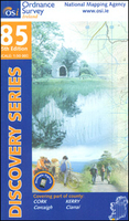
Cork - Kerry Discovery 85
Map No. 85, Cork Central-West in the Discovery series from the OSI, the Ordnance Survey of Ireland, which presents the country on detailed topographic maps at 1:50, 000, with additional overprint highlighting campsites and caravan parks, youth hostels, etc. Current 5th edition of this map was published in 2015.Maps in the Discovery series have contours at 10m intervals, with plenty of spot heights and additional altitude colouring. Graphics indicate different types of woodlands. An overprint highlights waymarked or unmarked walking trails as well as cycle routes. National or forest parks and nature reserves are marked and a range of symbols provide tourist information: campsites, caravan parks, youth hostels (An Óige and independent), tourist offices, parking and picnic places,
and viewpoints. Golf courses indicate the number of holes. The maps also highlight antiquities and historical sites such as megalithic tombs, standing stones, battlefields, etc. Road network grades third class roads according to their widths and includes local tracks. Railways are shown with stations and the maps include other details expected of topographic mapping at this scale. Where appropriate, place names are given in both Irish and English.Each map covers an area of 40 x 30km (25 x 19 miles approximately) and has a 1km ITM (Irish Transverse Mercator) grid, plus latitude and longitude margin ticks at 1` intervals. Map legend is in Irish and English. To see the list of all the titles in this series please click on the series link.
and viewpoints. Golf courses indicate the number of holes. The maps also highlight antiquities and historical sites such as megalithic tombs, standing stones, battlefields, etc. Road network grades third class roads according to their widths and includes local tracks. Railways are shown with stations and the maps include other details expected of topographic mapping at this scale. Where appropriate, place names are given in both Irish and English.Each map covers an area of 40 x 30km (25 x 19 miles approximately) and has a 1km ITM (Irish Transverse Mercator) grid, plus latitude and longitude margin ticks at 1` intervals. Map legend is in Irish and English. To see the list of all the titles in this series please click on the series link.

Product Description
Reviews/Comments
Add New
Vouchers
No voucher codes found.
Do you know a voucher code for this product or supplier? Add it to Insights for others to use.
Do you know a voucher code for this product or supplier? Add it to Insights for others to use.
 Denmark