
 United Kingdom
 France
 Germany
 Netherlands
 Sweden
 USA
USA
 Italy
Italy
 Spain
Spain
More From Contributor

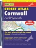


Cornwall Street Atlas
Cornwall Street Atlas in a spiral-bound edition at a scale of 4 inches to 1 mile (1:15, 840) in a series of street atlases of English counties from the Geographers' A-Z Map Company. The atlas covers selected areas of the county including Bodmin, Bude, Callington, Camborne, Camelford, Hayle, Helston, Falmouth, Fowey, Lauceston, Liskeard, Lostwithiel, Mevagissey, Newquay, Padstow, Penryn, Penzance, Redruth, St. Austell, St. Just, Saltash, Torpoint, Truro and Wadebridge. Enlargements cover in greater detail the centres of St. Ives and Looe.The atlas has a comprehensive index including separate entries for places of interest such as cultural and sport or recreational facilities, historical sites, nature reserves and gardens. Also provided are lists of hospitals and
hospices in the area covered by the atlas and a postcode map of the county. Current edition was published in 2008.
hospices in the area covered by the atlas and a postcode map of the county. Current edition was published in 2008.
Product Description
Reviews/Comments
Add New
Intelligent Comparison
Archived Product
Crawley Street Atlas Stanfords
£4.50
Archived Product
Carlisle Street Atlas Stanfords
£4.50
Archived Product
Torbay Street Atlas Stanfords
£3.95
Archived Product
Pretoria Street Atlas Stanfords
£18.95
Archived Product
Vienna Street Atlas Stanfords
£9.95
Archived Product

Moscow Street Atlas Stanfords
£24.95
Archived Product
Durham Street Atlas Stanfords
£4.50
Archived Product
Moscow Street Atlas Stanfords
£27.95
Vouchers
No voucher codes found.
Do you know a voucher code for this product or supplier? Add it to Insights for others to use.
Do you know a voucher code for this product or supplier? Add it to Insights for others to use.
 Denmark