
 United Kingdom
 France
 Germany
 Netherlands
 Sweden
 USA
USA
 Italy
Italy
 Spain
Spain
More From Contributor


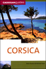
Corsica
Corsica at 1:135, 000 on an indexed road map with topographic and tourist information printed on light, waterproof and tear-resistant synthetic paper. The map, published by Reise Know-How as part of their highly acclaimed World Mapping Project, is double-sided to provide the best balance between a good scale and a convenient size sheet, and shows the island with a generous overlap between the two sides.Topography is indicated by altitude colouring plus spot heights and plenty of names mountain groups, peaks and other geographical features. Boundary of the Parc Naturel R
Product Description
Reviews/Comments
Add New
Vouchers
No voucher codes found.
Do you know a voucher code for this product or supplier? Add it to Insights for others to use.
Do you know a voucher code for this product or supplier? Add it to Insights for others to use.
 Denmark