
 United Kingdom
 France
 Germany
 Netherlands
 Sweden
 USA
USA
 Italy
Italy
 Spain
Spain
More From Contributor

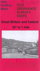
Craigavon
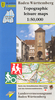
Map No. 20, Craigavon, in the Discoverer series from the Ordnance Survey of Northern Ireland presenting the country on detailed topographic maps at 1:50, 000 with waymarked hiking trails, Sustrans National Cycle Network and other tourist information. Coverage in this title includes Lisburn, Lurgan, Banbridge and Slieve Croob.The maps have contours at 10m intervals, with plenty of spot heights and bold altitude colouring above 150m. Graphics indicate different types of woodlands. In coastal areas the maps show high and low water mark, cliffs, mud/shingle or sand, etc. Road network grades minor roads according to their widths, includes local tracks and shows gradients on steep routes. Railways are shown with stations and the maps include other details expected of topographic
mapping at this scale.An overprint highlights waymarked walking trails as well as cycle routes of the Sustrans National Cycle Network. Boundaries of National Trust land are marked, indicating areas with limited opening. Places of interest are prominently highlighted and a range of symbols provide other tourist information including camping or caravan sites and youth hostels, bus stations, parking, picnic areas, viewpoints, gold courses, etc. Each map covers an area of 40 x 30km (25 x 19 miles approximately) and has a 1km UTM grid, plus latitude and longitude margin ticks at 1' intervals. Map legend is English, French and German. On the reverse each sheet has an indexed monochrome map showing townland boundaries. Please note: numbers not listed here cover the Irish Republic (Eire)
and are shown on our website in a separate
Product Description
Reviews/Comments
Add New
Intelligent Comparison
Archived Product
Craigavon Stanfords
£6.50
Archived Product
Craigavon Stanfords
£6.50
Archived Product
Croatian Stanfords
£3.99
Vouchers
No voucher codes found.
Do you know a voucher code for this product or supplier? Add it to Insights for others to use.
Do you know a voucher code for this product or supplier? Add it to Insights for others to use.
 Denmark