
 United Kingdom
 France
 Germany
 Netherlands
 Sweden
 USA
USA
 Italy
Italy
 Spain
Spain
More From Contributor


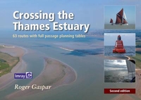
Crossing The Thames Estuary
63 routes with full passage tables An indispensable companion for planning Thames estuary passages, this set of tables enables navigators to select the best routes according to tide times. A set of tide tables, IMRAY charts, East Coast Pilot and Crossing the Thames Estuary provide all the information that is needed to fully explore the estuary and coasts of Suffolk, Essex and Kent. The object is help you plan your journey across the complex waters of the Thames Estuary quickly, safely, easily and accurately. To do this a series of tables is provided based upon a variety of routes with alternative tables for Springs and Neaps and for a choice of average boat speeds of 4, 5, 6 and 7 knots. As with the first edition, the concentration is on the `inside` routes that weave through or
across various sands and swatch ways. However, this edition now includes the `outside` route between the Suffolk Rivers and Ramsgate. The Time Planning tables will enable you to plan departure times to arrive at key points on the crossing at your chosen time.The purpose is to provide the reader with a simple and accurate way to determine the best choices when making the crossing: what is your preferred route? What time do I start to ensure sufficient water through swatch ways or over banks? What is the best compromise to get the most help from the tide and still have sufficient water over the banks? Please visit www.crossingthethamesestuary.com for corrections and changes, an illustrated `Notices to Mariners` service for the area covered by this book and a range of chart lets of Roger`s
surveys.

Product Description
Reviews/Comments
Add New
Vouchers
No voucher codes found.
Do you know a voucher code for this product or supplier? Add it to Insights for others to use.
Do you know a voucher code for this product or supplier? Add it to Insights for others to use.
 Denmark