
 United Kingdom
 France
 Germany
 Netherlands
 Sweden
 USA
USA
 Italy
Italy
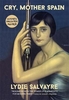
 Spain
Spain
More From Contributor


Crystal Marquise Blue
Crystal Marquise Blue (30cm / 12” diameter) is a blue land mass, transparent desktop globe that offers the enduring appeal of the globe, but with a thoroughly modern, visually intriguing twist. The globe ball is bisected by a stainless steel axis which is sculpted as one continuous piece from base beginning to axis tip.

Product Description
Reviews/Comments
Add New
Vouchers
No voucher codes found.
Do you know a voucher code for this product or supplier? Add it to Insights for others to use.
Do you know a voucher code for this product or supplier? Add it to Insights for others to use.
 Denmark