More From Contributor

£6.99
A build your own set, the globe comes with everything you need to construct your own stand & axis, plus two different globe maps representing day & night for you to fix & slot into place. The `day` map features a standard map of the Earth, with all the world`s major landmarks labelled. The `night` map is based on the night sky, & features the major star constellations accurately portrayed & labelled. Both maps are easy to assemble, with double sided tape & instructions provided. ...
Archived Product
£35.00
Pocket magnifying glass. Solid bronze surround with durable glass. Our Discovery Glass allows detailed examination of maps, coins, & other wonders. If we do not have this item in stock we will order it for you from our supplier. Delivery generally takes 3 weeks within the UK. For overseas delivery queries please email sales@stanfords.co.uk ...
Archived Product
£16.00
Make your own globe & discover more about the people & places on it with this stylish kit, containing all the pieces for an easy-to-make spinning model plus a highly-illustrated atlas. The sturdy card globe features icons labelling everything from natural wonders to famous faces, topics which can then be explored in more detail in the atlas. As well as referring closely to the model globe, the atlas covers a variety of themes including the Earth`s biomes, animals & World Heritage sites, providing a fascinating introduction to the world, its people & places. This beautifully-designed kit has everything any armchair adventurer needs to begin exploring their very own globe. ...
Archived Product
£8.99
It begins with absence & desire. It begins with blood & fear. It begins with a discovery of witches. When historian Diana Bishop opens an alchemical manuscript in the Bodleian Library, it`s an unwelcome intrusion of magic into her carefully ordered life. Though Diana is a witch of impeccable lineage, the violent death of her parents while she was still a child convinced her that human fear is more potent than any witchcraft. Now Diana has unwittingly exposed herself to a world she`s kept at bay for years; one of powerful witches, creative, destructive daemons & long-lived vampires. Sensing the significance of Diana`s discovery, the creatures gather in Oxford, among them the enigmatic Matthew Clairmont, a vampire genticist. Diana is inexplicably drawn to Matthew &, in a shadowy world of half-truths & old enmities, ties herself to him without fully understanding the ancient line they are crossing. As they begin to unlock the secrets of the manuscript & their feelings for each other deepen, so the fragile balance of peace unravels... ...
Archived Product
£7.99
I am going to cycle around the world. For something so major the words came out surprisingly easily. Time is ticking away. I have to do something now before my spirit is sucked out of me entirely. Discovery Road tells the story of Tim Garratt & Andy Brown s attempt to be the first people to mountain bike unsupported across the three southern continents in one year. They cross the vast deserts of Australia, the dangerous bush lands of Africa & finally the awesome Andes of South America, the continent where they had been assured they would meet their doom. It is a fast-moving, inspirational tale of self-discovery, full of adventure, conflict, humour, danger & a multitude of colourful characters. Much more than a travelogue, it proves that ordinary people can chase great dreams & has acted as inspiration for many searching for their adventure. ...
Archived Product
£6.95
About this series Circular walks along the less well-trodden paths of a county. The route of each walk is clearly shown on a sketch map & cross-referenced to Ordnance Survey maps. Black & white photographs are included & the descriptions clearly separate the background information from the directions. ...
Archived Product
£29.00
In the seventeenth century, a map of the plague suggested a radical idea-that the disease was carried & spread by humans. In the nineteenth century, maps of cholera cases were used to prove its waterborne nature. More recently, maps charting the swine flu pandemic caused worldwide panic & sent shockwaves through the medical community. In ” Disease Maps”, Tom Koch contends that to understand epidemics & their history we need to think about maps of varying scale, from the individual body to shared symptoms evidenced across cities, nations, & the world. ” Disease Maps” begins with a brief review of epidemic mapping today & a detailed example of its power. Koch then traces the early history of medical cartography, including pandemics such as European plague & yellow fever, & the advancements in anatomy, printing, & world atlases that paved the way for their mapping. Moving on to the scourge of the nineteenth century-cholera-Koch considers the many choleras argued into existence by the maps of the day, including a new perspective on John Snow`s science & legacy. Finally, Koch addresses contemporary outbreaks such as AIDS, cancer, & H1N1, & reaches into the future, toward the coming epidemics. Ultimately, ” Disease Maps” redefines conventional medical history with new surgical precision, revealing that only in maps do patterns emerge that allow disease theories to be proposed, hypotheses tested, & treatments advanced. ...
Archived Product
£12.99
Disentis/ Mustér, map No. 256, in the standard topographic survey of Switzerland at 1:50, 000 from Swisstopo, i.e. without the special overprint highlighting walking trails, local bus stops, etc, presented in Swisstopo’s hiking editions of the 50K survey. Highly regarded for their superb use of graphic relief & hill shading, the maps give an almost 3-D picture of Switzerland`s mountainous terrain. Contours are at 20m intervals. All the maps have a 1-km grid with the Swiss national coordinates. This standard version of the 50K survey covers the whole country on 78 small format sheets, with special larger format maps published for several popular tourist destinations. Small format sheets cover an area of 35 x 24 km (21 x 15 miles approx) & have map legend in the language of the area covered by the map. The special larger sheets cover 50 x 35 km (31 x 22 miles approx) & have no map legend, but a separate leaflet can be provided instead.PLEASE NOTE: the hiking editions of the 1:50, 000 Swisstopo survey are listed on our website in a separate series. ...
Archived Product
£18.99
Disentis/ Mustér area, map No. 256T, at 1:50, 000 in a special hiking edition of the country’s topographic survey, published by Swisstopo in cooperation with the Swiss Hiking Federation. Cartography, identical to the standard version of the survey, is highly regarded for its superb use of graphic relief & hill shading to provide an almost 3-D picture of Switzerland`s mountainous terrain. Contours are at 20m intervals. An overprint highlights routes maintained by the SHF, distinguishing between hiking routes, mountain routes requiring proper footwear, & alpine routes where equipment is needed. Paths which are part of the national or regional network of long-distance hiking routes are specially marked & in the more recent editions are annotated with their official numbers. The maps show mountain huts, refuges & in remote areas also inns, plus roads with bus service & the positions of bus stops. All the maps have a 1-km grid of the Swiss national coordinates. For a list of all the titles in this series, please click on the series link. ...
Archived Product
£22.99
Detailed ski map at 1:50, 000 from Swisstopo, the country’s national survey organization, showing routes for skiing and/or snowboarding, access by public transport, recommended itineraries, lists of mountain huts, etc. The series uses the cartography of Switzerland’s topographic survey, with additional colouring to show slopes steeper than 30°. An overprint highlights ski routes, indicating suggested direction, difficult passages & sections which must be covered on foot. Also marked are areas where it is forbidden to leave the routes shown on the map. The maps also highlight roads with bus routes, indicating individual bus stops, show ski lifts & funiculars, plus mark locations of refuges or other mountain accommodation. Each title has the Swiss national grid at intervals of 1km, plus latitude & longitude margin ticks at 1’. Some titles cover a larger area, with a part of an adjoining sheet printed on the reverse of the main map as indicated on our series grid. Where appropriate, ski information extends across the border to France & Italy. On the reverse are itineraries of routes recommended by the Swiss Alpine Club, indicating the degree of difficulty, plus lists of alpine huts with contact details. Map legend for the overprint

Includes::
English. The text about the routes & accommodation is in the main language of the area covered by the map. To see the list of all the titles in this series please click on the series link.

...
Archived Product

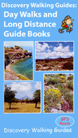
Discovery Walking Guides: Day Walks And Long Distance Guide Books

Discovery Walking Guides’ guide books cover day walks and long distance trails, with a depth of information giving you all you need for your walk, including map extracts, difficulty ratings and full-colour photos or illustrations.Most guides include GPS waymarked walking points, an extensive introduction provides information on the routes themselves, when to go, flora and fauna, tourist sites, and more. There is also useful guidance about map and walking information including details of walk location regional maps and using GPS. Each walk uses colour keys indicating difficulty, times, total distance, vertigo risks, ascents and descents and if refreshments are available on route.Appendices provide walkers with a summary of GPS Waypoints Lists (also available for download from
the publishers` website), useful telephone numbers and addresses, transport timetables and relevant websites. Thorough walk descriptions are accompanied by detailed map extracts mapping the route and GPS waypoints at every key point on the walk as well as colour photographs illustrating some of the highlights of each walk covered in each guide.
RIP - This product is no longer available on our network. It was last seen on 25.09.2019

This page now acts as a permanent archive for this product. Add more information using the comments box below to ensure it can still be found by future generations.

Use our search facility to see if it is available from an alternative contributor.
  • Availability: Out Of Stock
  • Supplier: Stanfords
  • SKU: SI00000859
Availability: In Stock
£11.99

Product Description

Discovery Walking Guides’ guide books cover day walks & long distance trails, with a depth of information giving you all you need for your walk, including map extracts, difficulty ratings & full-colour photos or illustrations. Most guides include GPS waymarked walking points, an extensive introduction provides information on the routes themselves, when to go, flora & fauna, tourist sites, & more. There is also useful guidance about map & walking information including details of walk location regional maps & using GPS. Each walk uses colour keys indicating difficulty, times, total distance, vertigo risks, ascents & descents & if refreshments are available on route. Appendices provide walkers with a summary of GPS Waypoints Lists (also available for download from the publishers` website), useful telephone numbers & addresses, transport timetables & relevant websites. Thorough walk descriptions are accompanied by detailed map extracts mapping the route & GPS waypoints at every key point on the walk as well as colour photographs illustrating some of the highlights of each walk covered in each guide.

Reviews/Comments

Add New

Intelligent Comparison

Oooops!
We couldn't find anything!
Perhaps this product's unique.... Or perhaps we are still looking for comparisons!
Click to bump this page and we'll hurry up.

Price History

Vouchers

No voucher codes found.
Do you know a voucher code for this product or supplier? Add it to Insights for others to use.

Facebook

Jargon Buster

GPS - Global Positioning System - Global position using satellites
Key - A physical or virtual device or code used for opening something
Telephone - A device used for communicating audio over long distances
Colour - The categorised spectrum of light visable to humans
Day - The time it takes a planet or other space objects to complete one rotation.
illustrations - Pictures typically in books and newspapers.
Regional - An adjective to describe a set geographic area.
Transport - Something that carries people or goods.

Supplier Information

Stanfords
Stanfords was established in 1853 and opened their iconic Covent Garden flagship store in 1901. They have become the top retailer of maps, travel books and accessories in the UK and arguably offer the largest selection of maps and travel books worldwide. Famous names such as Captain Robert Falcon Scott, Ranulph Fiennes and Michael Palin have purchased from Stanfords. They now have a shop in Bristol and both stores together with other venues operate a calendar of events including talks, book signings and exhibitions. As a specialist map retailer, the map selection is comprehensive and includes road maps, street maps and walking maps from worldwide destinations, as well as a selection of world atlases and wall maps. Books include travel guides and travel literature. Stanfords also stock globes, from miniatures made of blue marble to magnificent floor-standing globes. The website features a selection of interesting articles on travel topics.
Page Updated: 2023-11-12 20:15:36

Community Generated Product Tags

Oh No! The productWIKI community hasn't generated any tags for this product yet!
Menu