More From Contributor
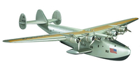
£9.99
Greg wakes up in a remote war zone, sole survivor of an air crash caused by a suicide bomber. Aman faces the disappearance of his wife & children in a family blood feud. Samira is forced to cope with the complexities of life as an asylum-seeker in the UK. Nuala must deal with the news that her husband is missing, presumed dead, victim of a terrorist atrocity. Divinity Road, Martin Pevsners first novel, traces the lives of four individuals & the unexpected links that bind them together. From violent conflict in Africa to the suburban streets of Oxford, it evokes a world of alienation & separation, fanaticism & cruelty, but ultimately celebrates the power of human solidarity & resilience. ...
Archived Product
£7.99
It is the 1970s in Northern California. A farmer & his teenage daughters, Anna & Claire, work the land with the help of Coop, the enigmatic young man who lives with them. Theirs` is a makeshift family, until they are riven by an incident of violence
- of both hand & heart
- that `sets fire to the rest of their lives`. This is a story of possession & loss, about the often discordant demands of family, love, & memory. Written in the sensuous prose for which Michael Ondaatje`s fiction is celebrated, ” Divisadero” is the work of a master story-teller.

...
Archived Product
£20.00
We are able to source a wide range flags in many sizes, sewn or printed on 100% Ministry Of Defence Standard Woven & Knitted Polyester. Flags are supplied with rope & toggle. If you would like more information, have a custom size request or cannot find a desired product, please email us at maritime@stanfords.co.uk. We will be glad to help! ...
Archived Product
£8.99
Kati owns Istanbul`s only mystery book store &, as usual, gets involved in a case that is none of her business. Every day, a beautiful woman lunches alone in the restaurant next to the bookstore. When the woman is found dead in her apartment, Kati immediately recognizes the stranger from the restaurant in images in the newspaper photos. Although the police believe it was an accident, Kati suspects something more sinister has happened. Sani Ankaraligil was an attractive young woman, in the middle of a divorce from her wealthy husband & a politically active ecologist. So who would benefit from her death? The industrial companies Sani had accused of polluting the rivers of Western Turkey, or her jealous husband seeking revenge through an honour killing, or a Thracian separatist group? The investigation pulls Kati into the murkiest of waters. ...
Archived Product
£5.99
Learn all about the traditions of Diwali with this third book in the delightful board book series Celebrate the World, which highlights special occasions & holidays across the globe. Each autumn we gather with our friends & family & light our brightest lanterns. It`s time for Diwali, the festival of lights! In this lovely board book with illustrations from Archana Sreenivasan, readers learn that the five days of Diwali are a time to pray for a bountiful season, celebrate the special bonds between siblings, & rejoice in the victory of light over darkness & good over evil. ...
Archived Product
£19.96
DIY Board Games allows kids to create beautiful games for the whole family to play. With five games in one
- snakes & ladders,
...
Archived Product
£11.50
Topographic survey of France at 1:25, 000 in IGN`s excellent TOP25 / Série Bleue series. All the maps are GPS compatible, with a 1km UTM grid plus latitude & longitude lines at 5’ intervals. Contours are at 5m intervals except for mountainous areas where the maps have contours at 10m intervals, vividly enhanced by hill shading & graphics for rocky terrain. Colouring with graphics indicates different types of vegetation or land use (deciduous or coniferous forests, moors, orchards, vineyards, etc). PLEASE NOTE: coverage of France at this scale is currently being revised – the format & the presentation of each title are indicated by the letters at the end of its Sheet Reference number (e.g. 0416ET, 3531ETR, 1923SB, etc.)MAPS WITH FULL TOURIST OVERPRINT & AN ENGLISH MAP LEGEND: all TOP25 maps & the SB editions of Série Bleue have an overprint highlighting waymarked walking trails including long-distance GR routes &, where appropriate, ski routes. Symbols indicate campsites, gîtes d’etape, refuges, equestrian centres & other recreational facilities or sites, tourist information centres, cultural heritage, etc. Towns & locations of particular interest are highlighted.- ET or OT = single-sided TOP25 map covering approx. 29x 21 km / 18x 13 miles.- ETR or OTR = waterproof & tear resistant TOP25 map covering the same area as the corresponding ET or OT number, but double-sided, printed on a smaller size sheet with a good overlap between the sides.- SB = Série Bleue map with full tourist overprint; these maps, first introduced in summer 2014, each cover approx. 29x 24km / 18x 15 miles.SÉRIE BLEUE maps with numbers ending in E (Est) or O (Ouest): most editions now indicate the GR routes, but do not show any other tourist information. Map legend is in French only. Each map covers approx. 14x 20km / 9x 12 miles. ...
Archived Product
£11.99
One of the titles in a series of topographic maps covering much of north-west Africa, produced as part of the IMW* project in 1960’s. Each map covers an area spanning 6° in longitude & 4° in latitude. There is some variation in colouring & the depiction of terrain, but hill-shading, spot heights & contours are used to show the general relief. Additional graphics show features such as dunes, rock outcrops, cliffs, sand areas, escarpments, marshes, seasonal lakes & watercourses, & areas liable to flooding. Bathymetric contours are also included. Communications detail

Includes::
roads, major trails & railways, although there is some inconsistency in colouring & the extent of classification, e.g. not all maps distinguish seasonal roads. On most maps intermediate road distances are indicated on main routes. Symbols show airports, mosques, mines, oil & gas fields, lighthouses, ruins & significant isolated buildings. Administrative boundaries are marked & latitude & longitude lines are drawn at 1° intervals, with further margin ticks at 1’ intervals. The map legend is in French only on some sheets, & in English & French on others.* The International Map of the World was a project conceived in the early 20th century to compile a world map series at 1:1, 000, 000 through the efforts of participating nations. The value of the program has declined since 1970 & the IMW is no longer regarded as an active international series.

...
Archived Product
£10.99
Djibouti at 1:200, 000 on an indexed map from the Institut Géographique National in Paris showing both the country’s road & rail networks & its physical geography, plus an enlargement of Djibouti City with its international airport. Road classification indicates unsurfaced routes &

Includes::
4WD trails & tracks. Intermediate distances are marked on main roads & important minor routes. The map also gives locations of fuel supplies. Railway lines are included & local aerodromes marked. Symbols indicate locations with tourist accommodation, post offices with telecommunication facilities, hospitals, etc. Relief is depicted by hill-shading complemented by contours & spot heights, with additional graphics for ridges & colours for landscape variations e.g. mangroves, areas liable to flooding, s&, forest etc. District boundaries are marked & latitude & longitude lines are drawn at 15’ intervals. The map of greater Djibouti City is at 1:50, 000 &

Includes::
adjacent Balbala & the international airport. No street names are marked but various buildings are indicated e.g. mosques, hospitals, the railway station. The map legend is in French only.


...
Archived Product

Dixie Clipper

Desktop display model. Metallic fabric covered lightweight wing and fuselage frames. Transparent portholes. Detailed engines. Nostalgic PanAm colors. Incredible detail. PanAm receives the first Boeing 314, the ultimate in luxury aircraft. Complete with sleeping berths and a real dining salon. It was the biggest plane of its time, carrying 74 passengers. The big flying boats were replaced after the war by land-based planes. With their demise an era of elegance passed that was never seen again. 152 ft wingspan. Five days, sixty hours in the air SFO-HK. When flying was still fun.If we do not have this item in stock we will order it for you from our supplier. Delivery generally takes 3 weeks within the UK. For overseas delivery queries please email sales@stanfords.co.uk
RIP - This product is no longer available on our network. It was last seen on 25.09.2019

This page now acts as a permanent archive for this product. Add more information using the comments box below to ensure it can still be found by future generations.

Use our search facility to see if it is available from an alternative contributor.
  • Availability: Out Of Stock
  • Supplier: Stanfords
  • SKU: 0781934530114
Availability: In Stock
£395.00

Product Description

Desktop display model. Metallic fabric covered lightweight wing & fuselage frames. Transparent portholes. Detailed engines. Nostalgic Pan Am colors. Incredible detail. Pan Am receives the first Boeing 314, the ultimate in luxury aircraft. Complete with sleeping berths & a real dining salon. It was the biggest plane of its time, carrying 74 passengers. The big flying boats were replaced after the war by l&-based planes. With their demise an era of elegance passed that was never seen again. 152 ft wingspan. Five days, sixty hours in the air SFO-HK. When flying was still fun. If we do not have this item in stock we will order it for you from our supplier. Delivery generally takes 3 weeks within the UK. For overseas delivery queries please email sales@stanfords.co.uk

Reviews/Comments

Add New

Intelligent Comparison

Oooops!
We couldn't find anything!
Perhaps this product's unique.... Or perhaps we are still looking for comparisons!
Click to bump this page and we'll hurry up.

Price History

Vouchers

No voucher codes found.
Do you know a voucher code for this product or supplier? Add it to Insights for others to use.

Facebook

Jargon Buster

UK - United Kingdom - An island nation in Europe
email - An electronic communication method. Short for Electronic Mail.
delivery - The method by which something is delivered from one location to another
Fun - Something that provides amusement or enterainment
Nostalgic - A memory for familiar things and wanting to get it back.
Luxury - An exquisite way of living, an sometimes come at a higher price.
Model - A representation of a person or thing, usually smaller scale. It can also be a person that wears clothing.

Supplier Information

Stanfords
Stanfords was established in 1853 and opened their iconic Covent Garden flagship store in 1901. They have become the top retailer of maps, travel books and accessories in the UK and arguably offer the largest selection of maps and travel books worldwide. Famous names such as Captain Robert Falcon Scott, Ranulph Fiennes and Michael Palin have purchased from Stanfords. They now have a shop in Bristol and both stores together with other venues operate a calendar of events including talks, book signings and exhibitions. As a specialist map retailer, the map selection is comprehensive and includes road maps, street maps and walking maps from worldwide destinations, as well as a selection of world atlases and wall maps. Books include travel guides and travel literature. Stanfords also stock globes, from miniatures made of blue marble to magnificent floor-standing globes. The website features a selection of interesting articles on travel topics.
Page Updated: 2023-11-12 20:15:36

Community Generated Product Tags

Oh No! The productWIKI community hasn't generated any tags for this product yet!
Menu