
 United Kingdom
 France
 Germany
 Netherlands
 Sweden
 USA
USA
 Italy
Italy
 Spain
Spain
More From Contributor


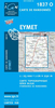


Eyre Peninsula, SA
Eyre Peninsula in South Australia on a touring map at 1:600, 000 from Carto Graphics, with on the reverse enlargements showing in greater detail The Lincoln National Park, Coffin Bay NP and the Gawler Ranges NP. Coverage extends east to include the Yorke Peninsula and Port Augusta, with to the west the Nullarbor Plain as far as the state border shown on an inset on the reverse.On one side is a touring map at 1:600, 000 covering the region between the Yorke Peninsula and Fowlers Bay; an inset on the reverse extends the coverage along the coast to the border of Western Australia. The map shows the region’s road network with driving distances on main routes and indicates locations of visitor information centres, lookouts and boat rumps along the coast. Topography is presented by relief
shading with colouring for protected areas. Latitude and longitude lines are drawn at 15’ intervals. The index, next to the map, includes a list of parks and reserves. Also provided is a distance table.On the reverse two coastal areas, Lincoln National Park and Coffin Bay National Park, plus the Gawler Ranges NP further inland are shown in greater detail at 1:150, 000 and with more tourist facilities. To see the list of the publisher`s other regional maps of South Australia please click on the series link.
shading with colouring for protected areas. Latitude and longitude lines are drawn at 15’ intervals. The index, next to the map, includes a list of parks and reserves. Also provided is a distance table.On the reverse two coastal areas, Lincoln National Park and Coffin Bay National Park, plus the Gawler Ranges NP further inland are shown in greater detail at 1:150, 000 and with more tourist facilities. To see the list of the publisher`s other regional maps of South Australia please click on the series link.

Product Description
Reviews/Comments
Add New
Vouchers
No voucher codes found.
Do you know a voucher code for this product or supplier? Add it to Insights for others to use.
Do you know a voucher code for this product or supplier? Add it to Insights for others to use.
 Denmark