
 United Kingdom
 France
 Germany
 Netherlands
 Sweden
 USA
USA
 Italy
Italy
 Spain
Spain
More From Contributor


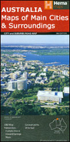
Gold Coast And Region Hema
Gold Coast and Region in Queensland in a series of maps from Hema presenting Australia’s main cities with three maps: a detailed street plan of the central area, a road map of the city with its outer suburbs, plus a map of the wider surrounding region for out-of-town excursions. The Gold Coast map has on one side street plans of the central Gold Coast area from Southport and Main Beach to Broad Beach, plus of Coolangatta – Tweed Heads, both with lists of accommodation facilities. The adjoining Gold Coast Suburban map at 1:37, 300 covers an area between the South Stradbroke Island and the state border and additionally highlight surfing beaches. On the reverse a regional map at 1:70, 500 of the Gold Coast and Hinterland covers a wider surrounding area including the Springbrook and
Lamington National Parks.Both the suburban and the regional maps are indexed and show the road network indicating unsurfaced roads and tracks. Symbols mark roadside rest areas, campsites, accredited information centres, places of interest, etc. Topography is indicated by names of mountain ranges and selected peaks, plus rivers and lakes; national and state parks, conservation areas and reserves are all highlighted. The both maps also show postal codes.To see other titles in this series please click on the series link.
Lamington National Parks.Both the suburban and the regional maps are indexed and show the road network indicating unsurfaced roads and tracks. Symbols mark roadside rest areas, campsites, accredited information centres, places of interest, etc. Topography is indicated by names of mountain ranges and selected peaks, plus rivers and lakes; national and state parks, conservation areas and reserves are all highlighted. The both maps also show postal codes.To see other titles in this series please click on the series link.

Product Description
Reviews/Comments
Add New
Vouchers
No voucher codes found.
Do you know a voucher code for this product or supplier? Add it to Insights for others to use.
Do you know a voucher code for this product or supplier? Add it to Insights for others to use.
 Denmark