More From Contributor
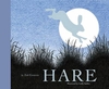
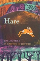
£12.99
Based upon the largest survey of restaurant-goers in the UK, this Harden`s bestseller is the discerning London restaurant goer`s bible. Over 600, 000 copies sold Nearly 50% more comprehensive than most comparable competitor Fully revised & updated each year on the basis of the UK`s most comprehensive survey of restaurant-goers. ...
Archived Product
£17.99
Kadaster, Holland`s national survey organization, produces one of the most attractive topographic surveys in Europe. The maps are very colourful, with their characteristic patchwork of polders & an unusually large amount of land use information: meadows, arable l&, different types of forest, marshes, sand dunes, etc. Contours are shown at 5-metre intervals with numerous spot heights &, with such a large part of the country below the sea level, ”spot depths”. Each map covers an area of Approx. 25 x 20 km / 15 x 12 miles, with some sheets slightly larger. The maps have a 1-km Dutch national grid, plus latitude & longitude at intervals of 1`. Map legend

Includes::
English.IMPORTANT
- PLEASE NOTE BEFORE ORDERING: both the west (W) & the east (O) sheet of each number has the same name, although the town after which the two maps are named appears only on one of the sheets. For example: maps 41W & 41O are both called Arnhem, although the city of Arnhem appears only on sheet 40W, etc. To see the list of titles available in this series please click on the series link.


...
Archived Product
£19.99
Western Australia state map coverage including an inset with coverage of south west Western Australia at a scale of 1:1, 870, 000 covering Lancelin & Kalgoorlie-Boulder in the north, Albany in the south & Norseman & Esperance in the east. This map clearly shows dual carriageways, national highways, & other roads, distances between towns, route numbers, towns with an indication of the size of each town & also comprehensive listing of towns, localities & homesteads. Also included are Visitor Information Centres, Deserts, Reserves, National & Marine Parks. This is an easy to read map that will help you find your way around Western Australia with ease & is ideal for both travel & business. Maps are also available for other Australian states & territories for a comprehensive coverage of Australia. ...
Archived Product
£25.00
Hardy’s Landscape Revisited is a twenty-first century look at Thomas Hardy’s Wessex, consisting of a series of described walks through the novelist’s literary landscapes. Based upon the texts of The Return of the Native, Far From the Madding Crowd, Under the Greenwood Tree, The Woodlanders, Tess of the d’ Urbervilles & Jude the Obscure, as well as incorporating excerpts from Hardy’s poems, Tony Fincham’s book allows the reader to appreciate the real world which formed the fictional stages. The author argues that Hardy’s landscapes, at once specific & general; based on real places & yet purposefully distanced & disguised, are an outward extension of a very narrow territory encompassing locations which, in “reality”, lay very close to the thatched cottage on Egdon Heath where Hardy was born. ...
Archived Product
£9.99
A celebration of nature ` Hare` takes us back to the wild. The elusive majesty of the hare has inspired human imagination for centuries. This book looks at the natural history & mythology of this beautiful & playful creature. ` Hare` opens a window onto the natural world for young children. Little ones will join the hunt for the hare & enjoy reciting the ancient poacher`s names for him. Older children will be fascinated by the legends & facts included at the end such as `10 Hare facts` & ` What`s the difference between a hare & a rabbit?` ...
Archived Product
£3.50
Harefield in 1935 in a fascinating series of reproductions of old Ordnance Survey plans in the Alan Godfrey Editions, ideal for anyone interested in the history of their neighbourhood or family. The map covers the village of Harefield, straddling the border between Middlesex & Hertfordshire (the small portion of Buckinghamshire is left blank). Features include village centre, The Green, Harefield House, Sanatorium, Mount Pleasant, Manor Court, Harefield Mills, River Colne, Grand Union Canal, etc. On the reverse are directory entries listing inhabitants in 1890 & 1933. About the Alan Godfrey Editions of the 25” OS Series: Selected towns in Great Britain & Ireland are covered by maps showing the extent of urban development in the last decades of the 19th & early 20th century. The plans have been taken from the Ordnance Survey mapping & reprinted at about 15 inches to one mile (1:4, 340). On the reverse most maps have historical notes & many also include extracts from contemporary directories. Most maps cover about one mile (1.6kms) north/south, one & a half miles (2.4kms) across; adjoining sheets can be combined to provide wider coverage.FOR MORE INFORMATION & A COMPLETE LIST OF ALL AVAILABLE TITLES PLEASE CLICK ON THE SERIES LINK. ...
Archived Product
£9.99
Harghita Mountains at 1:60, 000 in a series of detailed contoured maps covering popular hiking areas of Transylvania published by Dimap, one of Hungary’s leading publishers specializing in mapping of that region. The maps show local hiking routes & provide tourist information such as campsites, places of interest, etc. Many titles include street plans and/or English language descriptions of recommended hiking trails.* In this title:* hiking map with contours at 50m intervals, highlighting local hiking routes & indicating their waymarking. Nature reserves & forested areas are marked, & symbols show local spas & springs, caves, hotels & campsites, ski lifts, places of interest, etc. Two larger scale insets show the area around Harghita-Bai & gorges of the Vargyas with numerous caves. The map also

Includes::
a street plan of Miercurea-Ciuc. The map has a grid showing latitude & longitude at intervals of 1’. On the reverse are notes describing the area & lists of the waymarked hiking paths, plus a black & white overview map of the surrounding region.* Map legend & all the notes include English.*

...
Archived Product
£19.95
Hargreaves Associates has been at the forefront of landscape architectural practice since its founding in 1983. This volume presents projects from throughout the firm`s 25-year history, showing the development of its work from the early days to its current direction advancing the reoccupation of industrial sites, reclaiming waterfronts & creating new visions for public space. Whether reductive or rich, highly programmed or passive, culturally interpretive or teeming with the phenomena of natures own systems, the built landscapes of Hargreaves Associates seek the power of connection to our day-to-day lives. ...
Archived Product
£6.99
Hari is a dreamer with an unusual talent. He spends the few coins he earns washing cars on cinema trips to watch (and learn from) his beloved Bollywood films. Then one day Hari`s gloriously fancy footwork is spotted by Mr Ram, a man on a mission to resolve conflicts near & far. Hari so entrances everyone with his magical dancing that soon he is travelling all over the world & his electric feet bring harmony to all who see him dance. Particularly suitable for struggling, reluctant or dyslexic readers aged 8+ ...
Archived Product

Hare

”An utter delight” - Jennifer Tetlow. In the Encounters in the Wild series, renowned nature writer Jim Crumley gets up close and personal with British wildlife - here, the hare. With his inimitable passion and vision, Jim relives memorable encounters with some of our best-loved native species, offering intimate insights into their extraordinary lives.
RIP - This product is no longer available on our network. It was last seen on 25.09.2019

This page now acts as a permanent archive for this product. Add more information using the comments box below to ensure it can still be found by future generations.

Use our search facility to see if it is available from an alternative contributor.
  • Availability: Out Of Stock
  • Supplier: Stanfords
  • SKU: 9781910192139
Availability: In Stock
£10.00

Product Description

” An utter delight”
- Jennifer Tetlow. In the Encounters in the Wild series, renowned nature writer Jim Crumley gets up close & personal with British wildlife
- here, the hare. With his inimitable passion & vision, Jim relives memorable encounters with some of our best-loved native species, offering intimate insights into their extraordinary lives.

Reviews/Comments

Add New

Intelligent Comparison

Oooops!
We couldn't find anything!
Perhaps this product's unique.... Or perhaps we are still looking for comparisons!
Click to bump this page and we'll hurry up.

Price History

Vouchers

No voucher codes found.
Do you know a voucher code for this product or supplier? Add it to Insights for others to use.

Facebook

Jargon Buster

Personal - Something that belongs more to an individual due to it affecting them more by relating to them.
Vision - To be able to imagine, also can mean what you can see.

Supplier Information

Stanfords
Stanfords was established in 1853 and opened their iconic Covent Garden flagship store in 1901. They have become the top retailer of maps, travel books and accessories in the UK and arguably offer the largest selection of maps and travel books worldwide. Famous names such as Captain Robert Falcon Scott, Ranulph Fiennes and Michael Palin have purchased from Stanfords. They now have a shop in Bristol and both stores together with other venues operate a calendar of events including talks, book signings and exhibitions. As a specialist map retailer, the map selection is comprehensive and includes road maps, street maps and walking maps from worldwide destinations, as well as a selection of world atlases and wall maps. Books include travel guides and travel literature. Stanfords also stock globes, from miniatures made of blue marble to magnificent floor-standing globes. The website features a selection of interesting articles on travel topics.
Page Updated: 2023-11-12 20:15:36

Community Generated Product Tags

Oh No! The productWIKI community hasn't generated any tags for this product yet!
Menu