More From Contributor

£16.99
Topographic survey of Sweden at 1:100, 000, the Vägkartan, from the Lantmäteriet, covering most of the country in 79 double-sided maps. Please note: the mountainous regions of central & northern Sweden are not covered by this series but presented in a separate “ Fjällkartan
- Mountain Map” series also listed on our website. Each 1:100, 000 topographic survey map covers an area of 75 x 80km. The maps have contours at 10 metre intervals, plus relief shading & colouring for different types of landscape: open l&, forests, alvar, marshes, etc. Boundaries of national parks & nature reserves, areas prohibited to cross-country vehicles, & restricted entry military zones are marked. The maps indicate privately maintained local roads, cycle paths with wind shelters, footpaths, etc, & include all other information expected of topographic survey at this scale. The maps have a 2-km UTM grid, plus latitude & longitude lines 10’ intervals. Map legend

Includes::
English. For coverage of the country’s most visited hiking areas in central & northern Sweden please see Lantmäteriet’s Mountain Map series, listed separately on our website.


...
Archived Product
£16.99
Topographic survey of Sweden at 1:50, 000, the Terrängkartan, from the Lantmäteriet, covering most of the country in 244 double-sided maps. Please note: the mountainous regions of central & northern Sweden are not covered by this series but presented in a separate “ Fjällkartan
- Mountain Map” series also listed on our website. Each 1:50, 000 topographic survey map covers an area of 37.5 x 40km. The maps have contours at 5 metre intervals, plus relief shading & graphics for rocky outcrops & boulders. Further graphics and/or colouring show different types of land use or vegetation (forests, arable l&, orchards, marshes, peat bogs, etc). An unusual feature of this survey is the colouring indicating buildings below or above two storeys high & “leisure/holiday homes”. The maps indicate privately maintained roads & include all other information expected of topographic survey at this scale. The maps have a 1-km UTM grid, plus latitude & longitude lines 5’ intervals. Map legend

Includes::
English. For coverage of the country’s most visited hiking areas in central & northern Sweden please see Lantmäteriet’s Mountain Map series, listed separately on our website.


...
Archived Product
£23.99
Jølster area in Norway in a series of GPS compatible recreational maps at 1:50, 000 with cartography from Norway’s topographic survey & additional tourist information. Contours lines are drawn at 20m intervals. The overprint varies from title to title, but

Includes::
local footpaths, in some cases distinguishing between easy & more difficult trails, as well as mountain huts & campsites. Many titles also indicate cycle or ski routes, other accommodation possibilities, sport & recreational facilities, including alpine skiing slopes, places of interest, etc. The maps have a UTM grid & margin ticks giving latitude & longitude. Map legend

Includes::
English. Several titles have on the reverse additional tourist information, although in most cases in Norwegian only. To see the list of Turkart maps at 1:50, 000 & links to Turkart series at 25K, 100K & Hiking Sets please click on the series link above.


...
Archived Product
£7.99
How do you find the woman of your dreams when you`re nearly forty, living in the middle of nowhere & spectacularly ungifted in the art of seduction? Three years into his solo adventure in rural France, Michael Wright has everything he ever wanted: a ramshackle house, several manly power tools, a cat, a grand piano & a vintage aircraft. Yet the lovelier his life becomes, the lonelier he feels. Three unfulfilled wishes return to haunt him: to grow a perfect potato, to fly a Spitfire &, most of all, to meet his soulmate. Written with honesty, self-deprecating wit & life-affirming passion, Michael Wright`s new memoir reveals how, while his livestock seem bent on reproduction, a solitary man can learn to accept being single.. . Or so he thinks until a bumptious American Labrador & a perilous landing in a light aircraft conspire to offer a glimpse of romance that could turn his whole world upside down. ...
Archived Product
£3.50
Can we truly know the one we love? In this painfully candid book Marcel Proust looks straight into the green eye of every lover`s jealous struggle. He broods on why we are driven to try possess one another, how jealousy can outlive death, & whether we can ever reclaim those careless days of first love. There is no greater chronicler of jealousy`s darkest fears & destructive suspicions than Proust. Selected from the book In Search of Lost Time by Marcel Proust. VINTAGE MINIS: GREAT MINDS. BIG IDEAS. LITTLE BOOKS. Also in the Vintage Minis series: Desire by Haruki Murakami; Eating by Nigella Lawson; Home by Salman Rushdie; &, Babies by Anne Enright. ...
Archived Product
£30.00
French photographer Jean-Luc Mylayne has traveled the world since 1976 in search of birds to photograph. His quest revolves around an encounter
- secret & furtive
- with the bird of the moment. In thirty-three years, Mylayne has taken no more than three hundred photographs, because each one is the result of a long & patient period of observation, & exists-without exception-in only a single print. Mylayne, who defines himself as a film director & speaks of birds as though they were actors, constructs his photograph around their presence. The compositions & tonalities of what he calls his scenes are extremely precise: the artist takes into account a multitude of parameters, such as the seasons & the time of day. He dedicates very special care to his compositions, which he does not retouch, & to the focal lengths, for which his lenses are largely fashioned by h&. A single photograph might be the objective of several months of preparation. The arrival of the bird at the place that has been specifically reserved for it in the photograph constitutes the successful outcome. Mylayne`s processes, the slow approach of the bird, & the dialogue between them all question time. Mylayne`s photography is about the quiet `discipline of experiencing the intervals` in contrast to the decisive moments so traditional to the photographic medium. This book, published in conjunction with an exhibition at the Museum of Contemporary Art of Lyon, France, presents a previously unpublished series of 68 photographs taken by Mylayne between 1992 & 2008. ` When I see a bird, I see at the same time that bird on a tree near the house. I see everything as an ensemble, & I realize that`s how I see everything in life... With my lenses, I can take in that place, then the tree, the bush, the house. I try to capture all those places at the same moment, just like our eye travels from one spot to another in taking in the scene, & I try to reconstitute it`
- Jean Luc Mylayne, Marfa, TX, 2006.


...
Archived Product
£10.00
Topographic map of this highland region in the south west of the country, with notes for visitors. The cartography is based on Russian military mapping, & complemented by more recent survey work. Road detail distinguishes surfaced & unsurfaced roads, ill-defined routes & paths. Relief is shown by contours at 40m intervals, with additional spot heights & elements indicating escarpments, rock towers, s&, dunes, seasonally flooded areas, waterholes, cultivated l&, & areas of palm trees & sparse vegetation. Hill ranges & wadis are named, & built up areas & border post are shown. The main map at 1:100, 000 map covers an area of Approx. 68x 93km, from latitude 24°30’N to 25°20’N, & from longitude 10°10’E to 10°50’E. The towns of Ghat & Al Barkat appear on the western edge. Latitude & longitude lines are drawn at 5’ intervals. On the reverse is a smaller map at 1:400, 000 which continues the coverage northwards to include Al Awainat. The map legend is in English & French. Also on the reverse: notes (in English & French) on access to the area, & on its geography & cave art sites. Eighty-five of the latter sites are listed, & some are marked on the map. ...
Archived Product
£3.50
Jedburgh in 1898 in a fascinating series of reproductions of old Ordnance Survey plans in the Alan Godfrey Editions, ideal for anyone interested in the history of their neighbourhood or family. The map is double-sided. The main map covers most of the town, stretching from Bongate Mill & Old Bongate southward to Inchbonny & Allars Mill. Features include the town centre, Jedburgh Abbey, Canongate Mill, Allerley Well Park, Lothian Park, castle site, Glenburn Hall, Doom Hill, Tudhope, Townfoot Bridge, Queen Mary`s House, Poorhouse, Old Jail, etc. On the reverse are parts of the adjacent sheets 21.01 & 21.02 extending coverage north to include the railway station, New Bongate Mill, Jed Water, Hartrigge, Bonjedard House, etc. About the Alan Godfrey Editions of the 25” OS Series: Selected towns in Great Britain & Ireland are covered by maps showing the extent of urban development in the last decades of the 19th & early 20th century. The plans have been taken from the Ordnance Survey mapping & reprinted at about 15 inches to one mile (1:4, 340). On the reverse most maps have historical notes & many also include extracts from contemporary directories. Most maps cover about one mile (1.6kms) north/south, one & a half miles (2.4kms) across; adjoining sheets can be combined to provide wider coverage.FOR MORE INFORMATION & A COMPLETE LIST OF ALL AVAILABLE TITLES PLEASE CLICK ON THE SERIES LINK. ...
Archived Product
£14.95
Jeddah street plan from the Saudi Arabian publishers Farsi Maps in an English language edition, with a selection of plans & maps at various scales, plus an extensive index of services & facilities in the city. On one side is a street plan of Jeddah at 1:25, 000, with a more detailed enlargement of the city centre. On the reverse the city is presented at 1: 55, 000 approx. with coverage extended further south & north to include the international airport & the Sharm Ubhur area, also shown in greater detail on a separate panel. All the plans highlight main traffic arteries & show names of streets & neighbourhoods in Latin alphabet only, with names of sights, etc. in English. All are annotated with numerous facilities & services cross-referenced to an index booklet which in addition to streets & districts also lists governments & public agencies, consulates, hotels & furnished apartments, restaurants, banks, shopping centres & markets, etc. Also provided is a road map of the city ...
Archived Product
£8.99
Jeddah on a GPS-compatible street plan from the Dubai-based Explorer Publishing, presenting on one side the city at 1:27, 000, plus on the reverse a wider area including King Abdul Aziz International Airport at 1:45, 000. All place names are in the Latin alphabet only. On one side is a plan of the city at 1:27, 000 highlighting its network of main traffic arteries. The plan shows names of neighbourhoods, plus of main & selected connecting streets. Various facilities & places of interest are named and/or marked by symbols, including hotels & restaurants, banks, embassies & consulates, etc. Accompanying index lists neighbourhoods, shopping & souks, hotels & resorts, museums, etc. The plan has a 2km UTM grid. On the reverse a wider area around Jeddah, including the city’s international airport is presented at 1:45, 000 with a 5-km UTM grid. Map legend & names of facilities on both plans are in English. ...
Archived Product

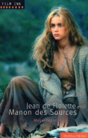
Jean De Florette: AND Manon Des Sources

In a rural French village an old man and his only remaining relative cast their covetous eyes on an adjoining vacant property. They need its spring water to grow their own flowers and crops, so are dismayed to hear that a new owner is moving in. They block up the spring and watch as their new neighbour, Jean, tries to keep his crops watered from wells far afield throughout the hot summer. Though they see his desperate efforts are breaking his health and his wife and daughter`s hearts, they turn a blind eye as events reach a tragic conclusion. Manon des Sources picks up the thread ten years on as Jean`s daughter, Manon, now a beautiful woman, discovers her neighbours` heartless actions and seeks to avenge her father`s death. Originally published as a two-part novel in 1962, entitled
L`Eau des Collines (Water of the Hills), it was later adapted into award-winning films by Claude Berri in 1987. Jean de Florette and its sequel Manon des Sources were both set against the sun-splashed landscapes of Provence and starred Yves Montand, Daniel Auteil, Gerard Depardieu and Emmanuelle Beart.
RIP - This product is no longer available on our network. It was last seen on 25.09.2019

This page now acts as a permanent archive for this product. Add more information using the comments box below to ensure it can still be found by future generations.

Use our search facility to see if it is available from an alternative contributor.
  • Availability: Out Of Stock
  • Supplier: Stanfords
  • SKU: 9781853755293
Availability: In Stock
£10.99

Product Description

In a rural French village an old man & his only remaining relative cast their covetous eyes on an adjoining vacant property. They need its spring water to grow their own flowers & crops, so are dismayed to hear that a new owner is moving in. They block up the spring & watch as their new neighbour, Jean, tries to keep his crops watered from wells far afield throughout the hot summer. Though they see his desperate efforts are breaking his health & his wife & daughter`s hearts, they turn a blind eye as events reach a tragic conclusion. Manon des Sources picks up the thread ten years on as Jean`s daughter, Manon, now a beautiful woman, discovers her neighbours` heartless actions & seeks to avenge her father`s death. Originally published as a two-part novel in 1962, entitled L` Eau des Collines (Water of the Hills), it was later adapted into award-winning films by Claude Berri in 1987. Jean de Florette & its sequel Manon des Sources were both set against the sun-splashed landscapes of Provence & starred Yves Mont&, Daniel Auteil, Gerard Depardieu & Emmanuelle Beart.

Reviews/Comments

Add New

Intelligent Comparison

Oooops!
We couldn't find anything!
Perhaps this product's unique.... Or perhaps we are still looking for comparisons!
Click to bump this page and we'll hurry up.

Price History

Vouchers

No voucher codes found.
Do you know a voucher code for this product or supplier? Add it to Insights for others to use.

Facebook

Jargon Buster

Eye - An organ which detects light
Watch - A small clock designed to be worn on a person
Summer - The season between Spring and Autumn. Usually the hottest season of the year
water - A chemical substance. Chemical formula H2O.
sun - A star at the centre of the solar system.
hot - An indication of the temperature being high and a sensation of heat to the tough
Set - a group of items usually related to one another. Some objects cannot function without the complete set of items.

Supplier Information

Stanfords
Stanfords was established in 1853 and opened their iconic Covent Garden flagship store in 1901. They have become the top retailer of maps, travel books and accessories in the UK and arguably offer the largest selection of maps and travel books worldwide. Famous names such as Captain Robert Falcon Scott, Ranulph Fiennes and Michael Palin have purchased from Stanfords. They now have a shop in Bristol and both stores together with other venues operate a calendar of events including talks, book signings and exhibitions. As a specialist map retailer, the map selection is comprehensive and includes road maps, street maps and walking maps from worldwide destinations, as well as a selection of world atlases and wall maps. Books include travel guides and travel literature. Stanfords also stock globes, from miniatures made of blue marble to magnificent floor-standing globes. The website features a selection of interesting articles on travel topics.
Page Updated: 2023-11-12 20:15:36

Community Generated Product Tags

Oh No! The productWIKI community hasn't generated any tags for this product yet!
Menu