
 United Kingdom
 France
 Germany
 Netherlands
 Sweden
 USA
USA
 Italy
Italy
 Spain
Spain
More From Contributor


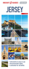
Jersey & Guernsey ITMB
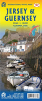
ITMB is pleased to re-introduce the Channel Islands map area after a lengthy hiatus. The islands, collectively known in English as the Channel Islands, are one of those anomalies that make Europe so attractive. There are actually, five inhabited islands, of which Jersey and Guernsey are the largest. Alderney, Sark, and Herm make up the others. Ferries link the islands, and tourism is a major activity of the islands, along with banking. Most visitors arrive on Jersey, which on our map occupies an entire side. The map shows all touristic attractions, roads, and rural restaurants/pubs. The reverse side is dominated by Guernsey, naturally, and its historic main town of St. Pete Port, but the shape of the island allowed us to include generous inset maps of Alderney and Sark,
while including tiny Herm in the main map. This map has two covers: one showing Jersey and Guernsey, and the other noting Guernsey and Jersey, with two different pictures. And in the upper right corner, the flags of each island. This is one of those ‘must see before death’ touristic destinations and is well worth the visit.Legend Includes:Ferry route, Highway, Main Road, Secondary Road, Hotel, Restaurant, Port, Point of interest, Ruins / Ancient sites, Pub, Domestic Airport etc.
while including tiny Herm in the main map. This map has two covers: one showing Jersey and Guernsey, and the other noting Guernsey and Jersey, with two different pictures. And in the upper right corner, the flags of each island. This is one of those ‘must see before death’ touristic destinations and is well worth the visit.Legend Includes:Ferry route, Highway, Main Road, Secondary Road, Hotel, Restaurant, Port, Point of interest, Ruins / Ancient sites, Pub, Domestic Airport etc.

Product Description
Reviews/Comments
Add New
Vouchers
No voucher codes found.
Do you know a voucher code for this product or supplier? Add it to Insights for others to use.
Do you know a voucher code for this product or supplier? Add it to Insights for others to use.
 Denmark