
 United Kingdom
 France
 Germany
 Netherlands
 Sweden
 USA
USA
 Italy
Italy
 Spain
Spain
More From Contributor


Jerusalem And North Israel
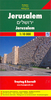
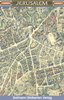
Jerusalem and North Israel on a light, waterproof and tear-resistant map combining a street plan of Jerusalem with an enlargement of the Old City, plus on the reverse a road map of Israel with the Negev Desert.On one side is coverage of Jerusalem: the city with its outer districts is shown on an indexed plan at 1:10, 000. On the eastern side of the Old City the plan includes the Mount of Olives and Mount Scopus, but in the west does not cover Yad Vashem or Mount Herzl. Main traffic routes are highlighted and locations of petrol stations and car parks are marked. The Jerusalem light rail route is shown with stops. The plan highlights numerous places of interest and facilities, including selected hotels, embassies, museums and other cultural or educational institutions, places of
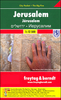
worship, Israeli governmental buildings, etc. Accompanying the main plan is a large, very clear enlargement at 1:4, 000 showing the Old City in greater detail, including the Stations of the Cross on Via Dolorosa. Also provided is a diagram of the existing and proposed light rail lines, plus a road map of the city
worship, Israeli governmental buildings, etc. Accompanying the main plan is a large, very clear enlargement at 1:4, 000 showing the Old City in greater detail, including the Stations of the Cross on Via Dolorosa. Also provided is a diagram of the existing and proposed light rail lines, plus a road map of the city
Product Description
Reviews/Comments
Add New
Vouchers
No voucher codes found.
Do you know a voucher code for this product or supplier? Add it to Insights for others to use.
Do you know a voucher code for this product or supplier? Add it to Insights for others to use.
 Denmark