
 United Kingdom
 France
 Germany
 Netherlands
 Sweden
 USA
USA
 Italy
Italy
 Spain
Spain
More From Contributor

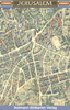


Jerusalem Old City Bird`s Eye View
Beautiful wall map showing bird’s-eye view plan of Jerusalem’s Old City and its immediate surrounding area, including Mount Zion, the City of David and Gethsemane. The buildings are drawn to scale with full architectural detail, viewed at a slightly oblique perspective looking northwards. All the important buildings are identified, using their English names, and the map provides a particularly good picture of the Western Wall and the Temple Mount with the Dome of the Rock and the El Aqsa Mosque.The map provides an excellent picture of this fascinating area, but it is not recommended as a street plan to be used whilst navigating the narrow lanes and alleyways of the Old City. The map was drawn in 1969, so any changes since that date, particularly in the area west of the Jaffa
Gate will not, of course, be reflected.This title is also available as a wall map.
Gate will not, of course, be reflected.This title is also available as a wall map.

Product Description
Reviews/Comments
Add New
Vouchers
No voucher codes found.
Do you know a voucher code for this product or supplier? Add it to Insights for others to use.
Do you know a voucher code for this product or supplier? Add it to Insights for others to use.
 Denmark