
 United Kingdom
 France
 Germany
 Netherlands
 Sweden
 USA
USA
 Italy
Italy
 Spain
Spain
More From Contributor


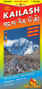


Kailas - Manasarovar
Mt Kailas and Lake Manasarovar on a detailed map from Nepa, showing access to the region by a trekking route from Simikot in Nepal. An enlargement shows Mt Kailas circuit at 1:66, 000, highlighting sacred places around the mountain.The map extends from Simikot in the upper Humla Karnali valley to Mount Kailas and beyond it to include the cave and hot springs at Thirthapuri. On the Nepali side the main trekking route from Simikot across the Nara La pass to the Tibetan border is highlighted, along with a possible return trek via Limi. On the Tibetan side roads suitable for vehicle are marked, plus trekking routes around Mt Kailas, Lake Manasarovar and to Thirthapuri.Symbols on both sides of the border show religious buildings, accommodation facilities and campsites, hot spring and
waterfalls, etc. Contours at 200m intervals with relief shading, spot heights and names of many peaks and passes. Margin ticks give latitude and longitude at 30’ intervals.An inset shows the Mount Kailas circuit in greater detail at 1:66, 000. The map has no contours, showing only the ridge lines with peaks and passes. Symbols mark numerous sacred places and religious buildings around the mountain and campsites. The index lists settlements, gompas, peaks and passes. Also included are profiles of the trek from Simikot to the Tibetan border and the alternative route back via Limi, with tables providing details of various stages of the routes, giving altitude in metres and feet plus trekking times.
waterfalls, etc. Contours at 200m intervals with relief shading, spot heights and names of many peaks and passes. Margin ticks give latitude and longitude at 30’ intervals.An inset shows the Mount Kailas circuit in greater detail at 1:66, 000. The map has no contours, showing only the ridge lines with peaks and passes. Symbols mark numerous sacred places and religious buildings around the mountain and campsites. The index lists settlements, gompas, peaks and passes. Also included are profiles of the trek from Simikot to the Tibetan border and the alternative route back via Limi, with tables providing details of various stages of the routes, giving altitude in metres and feet plus trekking times.

Product Description
Reviews/Comments
Add New
Vouchers
No voucher codes found.
Do you know a voucher code for this product or supplier? Add it to Insights for others to use.
Do you know a voucher code for this product or supplier? Add it to Insights for others to use.
 Denmark