
 United Kingdom
 France
 Germany
 Netherlands
 Sweden
 USA
USA
 Italy
Italy
 Spain
Spain
More From Contributor


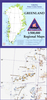

Kakadu National Park
Kakadu National Park route in a series of spiral-bound atlases from Design Interaction showing routes across Australia’s Northern Territory with GPS coordinates and accompanied by information about local facilities, useful tips and colour photos. The atlas has a latitude and longitude grid at intervals of 5’.Each atlas in this series presents the route on a plain base with colouring showing national parks/protected areas and Aboriginal lands. Topographic information is limited to rivers, creeks or lakes along the route or in its immediate vicinity. Along the route a wide range of symbols indicates various facilities including accommodation, food and fuel supplies, mechanical and tyre repair, emergency services, places of interest, etc. Driving distances are shown at regular
intervals and annotations provide tips about entry permits and fees, danger points, communication with emergency services, etc. Each route is shown in stages and accompanied by colour photos of interesting landscape features and other various points along it. Each page of the atlas has a latitude and longitude grid and various places along the route itself are annotated with GPS waypoints.Also provided is a list of useful addresses.
intervals and annotations provide tips about entry permits and fees, danger points, communication with emergency services, etc. Each route is shown in stages and accompanied by colour photos of interesting landscape features and other various points along it. Each page of the atlas has a latitude and longitude grid and various places along the route itself are annotated with GPS waypoints.Also provided is a list of useful addresses.

Product Description
Reviews/Comments
Add New
Vouchers
No voucher codes found.
Do you know a voucher code for this product or supplier? Add it to Insights for others to use.
Do you know a voucher code for this product or supplier? Add it to Insights for others to use.
 Denmark