
 United Kingdom
 France
 Germany
 Netherlands
 Sweden
 USA
USA
 Italy
Italy
 Spain
Spain
More From Contributor


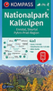

Kalkalpen NP - Pyhrn Priel Region - Hinterstoder - Windischgarsten
Map No. WK5501, Kalkalpen NP - Pyhrn Priel Region - Hinterstoder - Windischgarsten, in a series of outdoor leisure maps from Freytag & Berndt with hiking and cycling routes, plus other tourist information including GPS waypoints, huts and refuges, local bus stops, etc. The maps have contours at 100-metre intervals in the mountainous areas (50 metres elsewhere), shading and graphic relief. An overprint highlights hiking paths, indicating poorly waymarked sections and routes with fixed ropes, cycling routes and, on most of the titles, ski routes. The maps also show youth hostels, campsites, mountain huts and refuges, local bus stops, and various landmarks and places of interest. Each 1:50, 000 map covers approximately 52 x 38 km / 32 x 24 miles. Margin ticks show latitude and
longitude in steps of 5', and all new editions have a UTM grid. Map legend includes English. A separate booklet, in German only has a list of local mountain huts and refuges with contact details, a list of GPS waypoints for locations highlighted on the map, and brief descriptions of selected trails.Selected popular hiking areas are also covered by maps at more detailed scale: the WK5000 numbers are at 1:35, 000. These are basically enlargements of the 1:50, 000 cartography, but with some additional information. Similar booklets as for the 1:50, 000 maps are included.This title includes: UTM grid, GPS waypoints, index, cycle and mountain bike routes, ski routes, a booklet with a guide to the area.
longitude in steps of 5', and all new editions have a UTM grid. Map legend includes English. A separate booklet, in German only has a list of local mountain huts and refuges with contact details, a list of GPS waypoints for locations highlighted on the map, and brief descriptions of selected trails.Selected popular hiking areas are also covered by maps at more detailed scale: the WK5000 numbers are at 1:35, 000. These are basically enlargements of the 1:50, 000 cartography, but with some additional information. Similar booklets as for the 1:50, 000 maps are included.This title includes: UTM grid, GPS waypoints, index, cycle and mountain bike routes, ski routes, a booklet with a guide to the area.
Product Description
Reviews/Comments
Add New
Vouchers
No voucher codes found.
Do you know a voucher code for this product or supplier? Add it to Insights for others to use.
Do you know a voucher code for this product or supplier? Add it to Insights for others to use.
 Denmark