More From Contributor
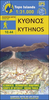
£13.50
Kyrgyzstan Wall Map at 1:750, 000 from Gizi Map, size 124 x 70cm (49” x 27.5” approx), with excellent presentation of the country’s mountainous terrain through bold altitude colouring & plenty of names of mountain ranges, etc, road network indicating routes of the old Silk Road, plus a street plan of Bishkek & an administrative map of the country. All place names are in the Latin alphabet. Topography is vividly shown by bold elevation colouring, with spot heights & graphics for swamps, salt flats & deserts, plus plenty of names of mountain ranges, peaks, valleys, etc. National parks are highlighted. The map shows internal provincial boundaries & also clearly indicates the country’s Uzbek & Tadjik enclaves. Road network

Includes::
selected local tracks & highlights routes which used to the part of the old Silk Road. Railway lines are included & local airports are marked. Symbols indicate various places of interest, locations with tourist accommodation including yurt camps, etc. Latitude & longitude lines are drawn at 30’ intervals. The map has on the reverse two separate but cross-referenced indexes, in Latin & Cyrillic script. Map legend

Includes::
English. Two panels provide a street plan of central Bishkek annotated with important buildings, selected hotels & places of interest, plus a small administrative map of the country. This title is also available as a folded map.


...
Archived Product
£23.99
Map No. 10089, Kyrksæterøra, in the new topographic survey of Norway at 1:50, 000 covering the country on 195 double-sided sheets & first published by Nordeca in 2011
- 2012; fully GPS compatible, indicating waymarked footpaths, campsites, tourist huts, illuminated ski runs, etc. The maps, now published by Nordeca, the successors to Statens Kartverk & its subsequent owners the Ugland Group, are printed on light, waterproof & tear-resistant synthetic paper. Each map covers an area of 62x 45 kilometres (39 x 28 miles approx.), with a 2-km overlap between the sheets. The maps have contours at 20m intervals (10m glacier contours), plus colouring & graphics to show cultivated areas, bogs, forests, etc. In addition to all the information expected of topographic mapping at this scale the maps distinguish between waymarked & unmarked footpaths & show campsites, tourist huts (serviced/self service/no supplies), country hotels & restaurants, & illuminated ski trails. The series uses EUREF89 (WGS84) datum & the maps have a 1-km UTM grid. Map legend is in Norwegian & English. Each title comes in a sturdy protective card envelope.
...
Archived Product
£9.95
Kythera with Antikythera & Elafonisos in the Mc Gilchrist’s Greek Islands series focuses primarily on cultural tourism for the visitor who wishes to understand more about the art, history & architecture of the islands. The series contains no photographs, but has specially drawn maps for each island (66 in total) & site plans for every major site (57 in total), together with thoroughly comprehensive textual information. Each guide also recommends a small number of places to stay & eat selected for their simplicity & unpretentiousness. ...
Archived Product
£7.50
Road Edition maps are produced in co-operation with the Hellenic Army Geographical Service, the national survey organisation. The maps have contours with colour altitude tints. All the place names are shown in both Greek & Roman script. Road classification distinguishes between unsurfaced roads of good & poor quality. Tourist information

Includes::
scenic routes, petrol stations, archaeological sites, campsites, beaches, etc. Brief descriptions, in Greek & English, illustrate some of the interesting aspects of each isl&. Map legend

Includes::
English. On the reverse, there are lists of various types of accommodation from hotels to private rooms. The islands is also sometimes known as Kythera. Please note: deliveries from Road Editions are not very reliable. For titles currently not in stock it may be advisable to choose a map from another publisher.


...
Archived Product
£9.99
Greek island of Kythira on a light, waterproof & tear-resistant, contoured & GPS compatible map at 1:35, 000 from Terrain Editions. Notes on the reverse the map include information on the island`s climbing sites & descriptions of four hiking trails. All place names are shown in both Greek & Latin alphabet. Map legend & all the text include English. Maps of the Greek islands from Terrain Editions have topography well presented by contours at 20m intervals (unless indicated differently in the map`s individual description), enhanced by spot heights, subtle relief shading & additional altitude colouring. Road network is very clearly graded according to width & the type of surface, distinguishing between good & rough dirt roads. Distances are marked on most small local roads, as well as locations of petrol stations and/or tyre repair workshops; scenic routes are highlighted. Each map also shows which ports are served by ferry services. Hiking paths are graded as main or narrow trails. National parks & other protected areas are marked & a wide range of symbols indicate various places of interest & recreational facilities, with main sights clearly highlighted. Most titles distinguish between sandy & pebble beaches; some also indicate beaches with natural shade and/or the type of sea bed. The maps have a UTM grid, plus latitude & longitude margin ticks. The reverse side of each title is covered by general information about the isl&, illustrated with colour photos. Many titles also include brief descriptions of recommended hiking trails and/or a street plan of the island’s main town, with colouring clearly showing various tourist facilities. To see the other titles in this series please click on the series link. ...
Archived Product
£5.99
The Aegean island of Kythnos on a light, waterproof & tear-resistant, contoured & GPS compatible map at 1:31, 000 from Anavasi with recommendations for nine hiking trails & descriptions of five most interesting sites. All place names are in both Greek & Latin alphabets. The island`s topography is shown by contours at 20m intervals, with relief shading & altitude colouring. Road network indicates dirt roads in poor condition & shows locations of petrol stations & driving distances on main roads. The map distinguishes between cart tracks & well defined, narrow or faint footpaths. Nine trails are highlighted & cross-referenced to a list giving their distance & approximate time. Symbols highlight various places of interest & facilities, including beaches, caves, archaeological remains, etc. The map has a 1km UTM grid plus latitude & longitude crosshairs at 1’. On the reverse, a smaller & simplified map of the island shows the road network & a selection of paths including the recommended routes, plus highlights five most interesting locations, each with a colour photo & a brief description. General notes about the island provide more information. Map legend & all the text include English. To see which other islands are covered by maps from Anavasi, please click on the series link. ...
Archived Product
£9.99
Kythnos Hiking Guide by Terrain Editions,

Includes::
eleven walks into history, nature & the most interesting

...
Archived Product
£9.99
Greek island of Kythnos on a light, waterproof & tear-resistant, contoured & GPS compatible map at 1:25, 000 from Terrain Editions, with astreet plan of the Hora of Kythnos at 1:2, 500, plus descriptions of 13 specially selected hiking trails. All place names are shown in both Greek & Latin alphabet. Map legend & all the text include English. Maps of the Greek islands from Terrain Editions have topography well presented by contours at 20m intervals (unless indicated differently in the map`s individual description), enhanced by spot heights, subtle relief shading & additional altitude colouring. Road network is very clearly graded according to width & the type of surface, distinguishing between good & rough dirt roads. Distances are marked on most small local roads, as well as locations of petrol stations and/or tyre repair workshops; scenic routes are highlighted. Each map also shows which ports are served by ferry services. Hiking paths are graded as main or narrow trails. National parks & other protected areas are marked & a wide range of symbols indicate various places of interest & recreational facilities, with main sights clearly highlighted. Most titles distinguish between sandy & pebble beaches; some also indicate beaches with natural shade and/or the type of sea bed. The maps have a UTM grid, plus latitude & longitude margin ticks. The reverse side of each title is covered by general information about the isl&, illustrated with colour photos. Many titles also include brief descriptions of recommended hiking trails and/or a street plan of the island’s main town, with colouring clearly showing various tourist facilities. To see the other titles in this series please click on the series link. ...
Archived Product
£17.99
The 1:50, 000 topographic map gives a more general picture of the ground features than a basic map. It shows settlements, houses, roads, cultivated areas, waterways, cutting areas, mires, rock exposures, & relief. One map sheet covers an area of 30 x 40 km & one centimetre corresponds to 500 metres on the ground. The 1:50, 000 topographic map is also an ideal complement to nautical charts as it provides useful information about the land areas adjacent to waterways. For example, all Finnish sea areas are covered by 1:50, 000 topographic map sheets. ...
Archived Product
£14.99
Lonely Planet Kuala Lumpur, Melaka & Penang is your passport to the most relevant, up-to-date advice on what to see & skip, & what hidden discoveries await you. Scale (by elevator!) the glistening Petronas Towers, spend-up big in one of KL`s air-conditioned shopping malls or sample local street food, all with your trusted travel companion. Get to the heart of Kuala Lumpur, Melaka & Penang & begin your journey now! Inside Lonely Planet`s Kuala Lumpur, Melaka & Penang Travel Guide: Colour maps & images throughout Highlights & itineraries help you tailor your trip to your personal needs & interests Insider tips to save time & money & get around like a local, avoiding crowds & trouble spots Essential info at your fingertips
- hours of operation, phone numbers, websites, transit tips, prices Honest reviews for all budgets
- eating, sleeping, sight-seeing, going out, shopping, hidden gems that most guidebooks miss Cultural insights give you a richer, more rewarding travel experience
- culture, history, art, literature, cinema, music, architecture, wildlife Free, convenient pull-out Kuala Lumpur map (included in print version), plus over 25 maps. Covers Golden Triangle, KLCC, Chinatown, Merdeka Square, Bukit Nanas, Masjid India, Kampung Baru, Northern Kuala Lumpur, Lake Gardens, Brickfields, Bangsar, Melaka, Penang, & more. The Perfect Choice: Lonely Planet Kuala Lumpur, Melaka & Penang, Lonely Planet’s most comprehensive guide to the region, is perfect for both exploring top sights & taking roads less travelled. Looking for more extensive coverage? Check out Lonely Planet`s Malaysia, Singapore & Brunei guide for a comprehensive look at all the region has to offer. Authors: Written & researched by Lonely Planet & Simon Richmond. About


...
Archived Product

Kythnos

Road Edition maps are produced in co-operation with the Hellenic Army Geographical Service, the national survey organisation. The maps have contours with colour altitude tints. All the place names are shown in both Greek and Roman script. Road classification distinguishes between unsurfaced roads of good and poor quality.Tourist information includes scenic routes, petrol stations, archaeological sites, campsites, beaches, etc. Brief descriptions, in Greek and English, illustrate some of the interesting aspects of each island. Map legend includes English. On the reverse, there are lists of various types of accommodation from hotels to private rooms. Please note: deliveries from Road Editions are not very reliable. For titles currently not in stock it may be advisable to choose a
map from another publisher.
RIP - This product is no longer available on our network. It was last seen on 25.09.2019

This page now acts as a permanent archive for this product. Add more information using the comments box below to ensure it can still be found by future generations.

Use our search facility to see if it is available from an alternative contributor.
  • External links may include paid for promotion
  • Availability: Out Of Stock
  • Supplier: Stanfords
  • SKU: 9789608189140
Availability: In Stock
£7.50

Product Description

Road Edition maps are produced in co-operation with the Hellenic Army Geographical Service, the national survey organisation. The maps have contours with colour altitude tints. All the place names are shown in both Greek & Roman script. Road classification distinguishes between unsurfaced roads of good & poor quality. Tourist information

Includes::
scenic routes, petrol stations, archaeological sites, campsites, beaches, etc. Brief descriptions, in Greek & English, illustrate some of the interesting aspects of each isl&. Map legend

Includes::
English. On the reverse, there are lists of various types of accommodation from hotels to private rooms. Please note: deliveries from Road Editions are not very reliable. For titles currently not in stock it may be advisable to choose a map from another publisher.

Reviews/Comments

Add New

Intelligent Comparison

Oooops!
We couldn't find anything!
Perhaps this product's unique.... Or perhaps we are still looking for comparisons!
Click to bump this page and we'll hurry up.

Price History

Vouchers

No voucher codes found.
Do you know a voucher code for this product or supplier? Add it to Insights for others to use.

Facebook

Jargon Buster

Colour - The categorised spectrum of light visable to humans
Quality - An object that has quality is superior in function and finish than a less quality object.
Road - a manmade lane or a path that is used to speed up travel.
Altitude - Something that can be quite high in relation to sea or ground level.
Accommodation - A room in which someone can live in, for example in a hotel
Reliable - Something that is consistently good and can be trusted.

Supplier Information

Stanfords
Stanfords was established in 1853 and opened their iconic Covent Garden flagship store in 1901. They have become the top retailer of maps, travel books and accessories in the UK and arguably offer the largest selection of maps and travel books worldwide. Famous names such as Captain Robert Falcon Scott, Ranulph Fiennes and Michael Palin have purchased from Stanfords. They now have a shop in Bristol and both stores together with other venues operate a calendar of events including talks, book signings and exhibitions. As a specialist map retailer, the map selection is comprehensive and includes road maps, street maps and walking maps from worldwide destinations, as well as a selection of world atlases and wall maps. Books include travel guides and travel literature. Stanfords also stock globes, from miniatures made of blue marble to magnificent floor-standing globes. The website features a selection of interesting articles on travel topics.
Page Updated: 2023-11-12 20:15:36

Community Generated Product Tags

Oh No! The productWIKI community hasn't generated any tags for this product yet!
Menu