
 United Kingdom
 France
 Germany
 Netherlands
 Sweden
 USA
USA
 Italy
Italy
 Spain
Spain
More From Contributor


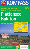
Lake Balaton
Lake Balaton and the surrounding area on a detailed double-sided map from Kompass, Europe’s leading publishers of walking maps, whose extensive series of maps of Central Europe, Italy, Spanish islands, etc. can also be found on our website. The map has contours at 10m intervals (although its legend puts the interval at 20m in English, German and French and 40m in Hungarian!), spot heights and relief shading, plus colouring and/or graphics to indicate various types of vegetation, including vineyards, orchard and hop fields.Hiking paths and other local trails are highlighted, indicating where appropriate their waymarking. Cycle and mountain bike routes are also marked. A wide range of symbols highlight various sport and recreational sites and facilities, places of interest,
campsites and youth hostels, etc. The map has a 2km UTM grid. *Map legend includes English.*The map comes with a 46 page booklet, in German and Hungarian, describing various places of interest around the lake. The booklet is not available in an English version.
campsites and youth hostels, etc. The map has a 2km UTM grid. *Map legend includes English.*The map comes with a 46 page booklet, in German and Hungarian, describing various places of interest around the lake. The booklet is not available in an English version.

Product Description
Reviews/Comments
Add New
Vouchers
No voucher codes found.
Do you know a voucher code for this product or supplier? Add it to Insights for others to use.
Do you know a voucher code for this product or supplier? Add it to Insights for others to use.
 Denmark