More From Contributor

£9.50
Lazio at 1:200, 000 in Mair Dumont's Marco Polo regional series of Italy with special features to aid navigation & route planning. The index in a separate booklet

Includes::
three street plans of central Rome, plus Pescara.A fold-out extension of the map cover gives at-a-glance overview of the whole area covered by the map with the adjoining regions, highlighting main places of interest & making it much easier to find various localities on the main map and/or plan a route. A set of seven peel-on/peel-off stickers, removable without damaging the map, is provided to make routes or locations more prominent when navigating. The maps boldly stress main roads & motorways in strong colours & selected towns in large letters, but also show minor roads & villages in considerable detail. Road information

Includes::
toll roads, traffic restrictions & seasonal closures, gradient marking for steep roads, scenic routes, etc. Motorway services clearly indicate types of facilities available there. Railway network

Includes::
narrow gauge & tourist lines, cable car lines, & chair lifts. The series is particularly good for identifying geographical

Features:
mountain & hill chains, valleys, national parks, etc. Picturesque towns & places of interest are given star rating, & other tourist information

Includes::
campsites & youth hostels, landmarks, recreational facilities etc. Latitude & longitude grid is drawn at intervals of 10'. Multilingual map legend & all information include English. Each title comes with a booklet which contains a street plan of the central area in the region


...
Archived Product
£9.99
Lazio at 1:200, 000 in Mair Dumont`s Marco Polo regional series of Italy with special features to aid navigation & route planning. The index in a separate booklet

Includes::
three street plans of central Rome, plus Pescara.A fold-out extension of the map cover gives at-a-glance overview of the whole area covered by the map with the adjoining regions, highlighting main places of interest & making it much easier to find various localities on the main map and/or plan a route. A set of seven peel-on/peel-off stickers, removable without damaging the map, is provided to make routes or locations more prominent when navigating. The maps boldly stress main roads & motorways in strong colours & selected towns in large letters, but also show minor roads & villages in considerable detail. Road information

Includes::
toll roads, traffic restrictions & seasonal closures, gradient marking for steep roads, scenic routes, etc. Motorway services clearly indicate types of facilities available there. Railway network

Includes::
narrow gauge & tourist lines, cable car lines, & chair lifts. The series is particularly good for identifying geographical

Features:
mountain & hill chains, valleys, national parks, etc. Picturesque towns & places of interest are given star rating, & other tourist information

Includes::
campsites & youth hostels, landmarks, recreational facilities etc. Latitude & longitude grid is drawn at intervals of 10`. Multilingual map legend & all information include English. Each title comes with a booklet which contains a street plan of the central area in the region’s main city, plus an extensive index of place names including geographical features. Also provided are a table with distances & traveling times & main traffic & speed regulations.


...
Archived Product
£11.99
Lazio: Rome
- L` Aquila
- Pescara map at 1:200, 000 from Kümmerly & Frey with cartography from the Italian publishers de Agostini.

...
Archived Product
£10.99
Lazio region of Italy at a detailed scale of 1:150, 000 on a large, double-sided map in Freytag & Berndt’s very popular “ Top 10 Tips” series. A booklet attached to the map cover provides descriptions of the region’s 10 best sights, a street plan of central Rome & a plan of the Vatican City, plus the map index. Many place names are in large print to make navigating easier. Rome is included on both sides of the map & coverage extends north beyond Orvieto & Spoleto, & south-east to Monte Casino. Maps in this series have topography well presented by subtle hill-shading with spot heights, plus colouring for woodlands; national & regional parks are highlighted. Road network emphasizes motorways & regional roads, but also

Includes::
small local roads & selected country tracks, most annotated with driving distances. Scenic routes are highlighted & the maps show roads closed to motor vehicles and/or not recommended for caravans, winter closures, toll routes, etc. Names of larger local towns are in bold print, making navigating in unfamiliar terrain much easier. Railway lines & ferry routes are included & local airports are marked. Picturesque locations are highlighted & in each title 10 best places of interest are prominently marked & briefly described in a booklet attached to the map cover. Symbols indicate various landmarks & facilities, e.g. archaeological sites, churches & castles, campsites, hostels, etc. Latitude & longitude lines are drawn at 10` intervals. The index, listing all the localities with their postcodes, is in the booklet attached to the map cover. The booklet also provides street plan (s) of the region’s main town (s). Map legend & the descriptions include English. To see other titles in this series please click on the series link.

...
Archived Product
£5.99

Includes: enlargements of Rome, Tivoli, Viterbo- all separately indexed. About this series: Indexed 1:200, 000 scale
...
Archived Product
£7.99
With a failed marriage behind her, La
- short for Lavender
- moves to the Suffolk countryside on the eve of the Second World

...
Archived Product
£22.99
L’île de L Réunion. a French language topoguide from the Fédération Française de la Randonnée Pédestre as part of their extensive series of similar walking guides to France & its overseas departments. The guide covers three long-distance footpaths: GR R1
- Tour du Piton des Neiges, GR R2 from Basse-Vallée to St Denis crossing the isl&, & GR R3
- Tour de Mafate. Colour extracts from the topographic survey of Reunion at 1:25, 000 are overprinted with the routes. The descriptions of the routes are divided into short sections according to the difficulty of the terrain, & are always placed next to the maps for easy reference. The text is in French, but a large amount of information is conveyed by symbols. A list of all the main points along the routes indicates what facilities can be found there: public transport, food shops, accommodation etc. The guide also

Includes::
lists with contact addresses for various types of accommodation along the three routes, as well as for airlines, car hire, tourist offices, etc. A separate section, with beautiful drawings, is devoted to Reunion’s flora & fauna. Also included are notes on the island’s history, climate etc. The guide is illustrated with numerous photos. Current edition of this title was published in May 2014.


...
Archived Product
£16.99
Topographic survey of Sweden at 1:50, 000, the Terrängkartan, from the Lantmäteriet, covering most of the country in 244 double-sided maps. Please note: the mountainous regions of central & northern Sweden are not covered by this series but presented in a separate “ Fjällkartan
- Mountain Map” series also listed on our website. Each 1:50, 000 topographic survey map covers an area of 37.5 x 40km. The maps have contours at 5 metre intervals, plus relief shading & graphics for rocky outcrops & boulders. Further graphics and/or colouring show different types of land use or vegetation (forests, arable l&, orchards, marshes, peat bogs, etc). An unusual feature of this survey is the colouring indicating buildings below or above two storeys high & “leisure/holiday homes”. The maps indicate privately maintained roads & include all other information expected of topographic survey at this scale. The maps have a 1-km UTM grid, plus latitude & longitude lines 5’ intervals. Map legend

Includes::
English. For coverage of the country’s most visited hiking areas in central & northern Sweden please see Lantmäteriet’s Mountain Map series, listed separately on our website.


...
Archived Product
£23.99
Lærdal area in Norway in a series of GPS compatible recreational maps at 1:50, 000 with cartography from Norway’s topographic survey & additional tourist information. Contours lines are drawn at 20m intervals. The overprint varies from title to title, but

Includes::
local footpaths, in some cases distinguishing between easy & more difficult trails, as well as mountain huts & campsites. Many titles also indicate cycle or ski routes, other accommodation possibilities, sport & recreational facilities, including alpine skiing slopes, places of interest, etc. The maps have a UTM grid & margin ticks giving latitude & longitude. Map legend

Includes::
English. Several titles have on the reverse additional tourist information, although in most cases in Norwegian only. To see the list of Turkart maps at 1:50, 000 & links to Turkart series at 25K, 100K & Hiking Sets please click on the series link above.


...
Archived Product

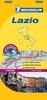
Lazio TCI Regional 10

Lazio in Touring Club Italiano’s series of regional road maps of Italy at 1:200, 000, used by millions of locals and tourists alike and always among Stanford’s perennial best-sellers. Coverage extends from Grosseto in the north-west, Orvieto, Spoleto and Teramo southwards to Gaeta, and eastwards to Pescara and Isernia, and includes Colli Albani with Castel Gandolfo, Anzio, Monte Cassino, Civitavecchia, Lago di Bolsano, Rieti, Terni, L’Aquila, Monti della Laga and Gran Sasso d’Italia National Parks, Abruzzo-Molise NP, etc.TCI maps have subtle but very effective relief shading plus spot heights to present the topography. Names of mountain ranges, valleys, peaks, etc. are shown and national parks and other protected areas are prominently highlighted. Road network is
presented in great detail, from motorways to dirt tracks navigable only with difficulty. Minor roads are very clear and easy to read and, where necessary, are drawn without generalizing their course, showing the twists and turns across the mountainous terrain. Steep roads are annotated with three levels of gradient markings. Scenic routes are highlighted. Motorways have the usual features such as toll barriers, services, etc. Railway network shows stations and level crossings and, where appropriate, ferry routes are marked. In mountainous areas refuges, cable car lines, chair lifts, etc. are markedTowns and villages of particular interest are highlighted in three grades, with symbols indicating various monuments, castes, churches, etc. The maps have no geographical
co-ordinates. On the reverse each title has an index plus a national distance table. Map legend includes English.To see the other titles in this series please click on the series link.
RIP - This product is no longer available on our network. It was last seen on 25.09.2019

This page now acts as a permanent archive for this product. Add more information using the comments box below to ensure it can still be found by future generations.

Use our search facility to see if it is available from an alternative contributor.
  • Availability: Out Of Stock
  • Supplier: Stanfords
  • SKU: 9788836569038
Availability: In Stock
£9.50

Product Description

Lazio in Touring Club Italiano’s series of regional road maps of Italy at 1:200, 000, used by millions of locals & tourists alike & always among Stanford’s perennial best-sellers. Coverage extends from Grosseto in the north-west, Orvieto, Spoleto & Teramo southwards to Gaeta, & eastwards to Pescara & Isernia, &

Includes::
Colli Albani with Castel Gandolfo, Anzio, Monte Cassino, Civitavecchia, Lago di Bolsano, Rieti, Terni, L’ Aquila, Monti della Laga & Gran Sasso d’ Italia National Parks, Abruzzo-Molise NP, etc.TCI maps have subtle but very effective relief shading plus spot heights to present the topography. Names of mountain ranges, valleys, peaks, etc. are shown & national parks & other protected areas are prominently highlighted. Road network is presented in great detail, from motorways to dirt tracks navigable only with difficulty. Minor roads are very clear & easy to read &, where necessary, are drawn without generalizing their course, showing the twists & turns across the mountainous terrain. Steep roads are annotated with three levels of gradient markings. Scenic routes are highlighted. Motorways have the usual features such as toll barriers, services, etc. Railway network shows stations & level crossings &, where appropriate, ferry routes are marked. In mountainous areas refuges, cable car lines, chair lifts, etc. are marked Towns & villages of particular interest are highlighted in three grades, with symbols indicating various monuments, castes, churches, etc. The maps have no geographical co-ordinates. On the reverse each title has an index plus a national distance table. Map legend

Includes::
English. To see the other titles in this series please click on the series link.

Reviews/Comments

Add New

Intelligent Comparison

Oooops!
We couldn't find anything!
Perhaps this product's unique.... Or perhaps we are still looking for comparisons!
Click to bump this page and we'll hurry up.

Price History

Vouchers

No voucher codes found.
Do you know a voucher code for this product or supplier? Add it to Insights for others to use.

Facebook

Jargon Buster

Cable - A series of wires bonded to form a single thread
Car - A machine used for transport which runs on roads
Italy - a country in Europe.
Network - A link and communication between things. Often computers or people.
Road - a manmade lane or a path that is used to speed up travel.
Regional - An adjective to describe a set geographic area.
Subtle - Something that is delicate and not to harsh, can be difficult to describe.
perennial - A plant that lives for more than two years. Tending to bloom during spring and summer to die back to root over winter.

Supplier Information

Stanfords
Stanfords was established in 1853 and opened their iconic Covent Garden flagship store in 1901. They have become the top retailer of maps, travel books and accessories in the UK and arguably offer the largest selection of maps and travel books worldwide. Famous names such as Captain Robert Falcon Scott, Ranulph Fiennes and Michael Palin have purchased from Stanfords. They now have a shop in Bristol and both stores together with other venues operate a calendar of events including talks, book signings and exhibitions. As a specialist map retailer, the map selection is comprehensive and includes road maps, street maps and walking maps from worldwide destinations, as well as a selection of world atlases and wall maps. Books include travel guides and travel literature. Stanfords also stock globes, from miniatures made of blue marble to magnificent floor-standing globes. The website features a selection of interesting articles on travel topics.
Page Updated: 2023-11-12 20:15:36

Community Generated Product Tags

Oh No! The productWIKI community hasn't generated any tags for this product yet!
Menu