More From Contributor
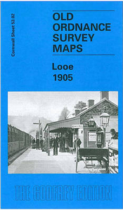
£9.95
Lonquimay Region at 1:100, 000 in a series of contoured, GPS compatible trekking & exploration maps at various scales form Trekkingchile, printed on sturdy, waterproof & tear-resistant plastic paper. Recreational maps from Trekkingchile are annotated with tourist information & most titles include a street plan of the region ...
Archived Product
£11.50
Topographic survey of France at 1:25, 000 in IGN`s excellent TOP25 / Série Bleue series. All the maps are GPS compatible, with a 1km UTM grid plus latitude & longitude lines at 5’ intervals. Contours are at 5m intervals except for mountainous areas where the maps have contours at 10m intervals, vividly enhanced by hill shading & graphics for rocky terrain. Colouring with graphics indicates different types of vegetation or land use (deciduous or coniferous forests, moors, orchards, vineyards, etc). PLEASE NOTE: coverage of France at this scale is currently being revised – the format & the presentation of each title are indicated by the letters at the end of its Sheet Reference number (e.g. 0416ET, 3531ETR, 1923SB, etc.)MAPS WITH FULL TOURIST OVERPRINT & AN ENGLISH MAP LEGEND: all TOP25 maps & the SB editions of Série Bleue have an overprint highlighting waymarked walking trails including long-distance GR routes &, where appropriate, ski routes. Symbols indicate campsites, gîtes d’etape, refuges, equestrian centres & other recreational facilities or sites, tourist information centres, cultural heritage, etc. Towns & locations of particular interest are highlighted.- ET or OT = single-sided TOP25 map covering approx. 29x 21 km / 18x 13 miles.- ETR or OTR = waterproof & tear resistant TOP25 map covering the same area as the corresponding ET or OT number, but double-sided, printed on a smaller size sheet with a good overlap between the sides.- SB = Série Bleue map with full tourist overprint; these maps, first introduced in summer 2014, each cover approx. 29x 24km / 18x 15 miles.SÉRIE BLEUE maps with numbers ending in E (Est) or O (Ouest): most editions now indicate the GR routes, but do not show any other tourist information. Map legend is in French only. Each map covers approx. 14x 20km / 9x 12 miles. ...
Archived Product
£8.99
Map No. 143, Lons-le-Saunier
- Geneva, at 1:100, 000, part of the TOP100 series from the Institut Géographique National (IGN).
...
Archived Product
£12.99
Topographic survey of France at 1:25, 000 in IGN`s excellent TOP25 / Série Bleue series. All the maps are GPS compatible, with a 1km UTM grid plus latitude & longitude lines at 5’ intervals. Contours are at 5m intervals except for mountainous areas where the maps have contours at 10m intervals, vividly enhanced by hill shading & graphics for rocky terrain. Colouring with graphics indicates different types of vegetation or land use (deciduous or coniferous forests, moors, orchards, vineyards, etc). PLEASE NOTE: coverage of France at this scale is currently being revised – the format & the presentation of each title are indicated by the letters at the end of its Sheet Reference number (e.g. 0416ET, 3531ETR, 1923SB, etc.)MAPS WITH FULL TOURIST OVERPRINT & AN ENGLISH MAP LEGEND: all TOP25 maps & the SB editions of Série Bleue have an overprint highlighting waymarked walking trails including long-distance GR routes &, where appropriate, ski routes. Symbols indicate campsites, gîtes d’etape, refuges, equestrian centres & other recreational facilities or sites, tourist information centres, cultural heritage, etc. Towns & locations of particular interest are highlighted.- ET or OT = single-sided TOP25 map covering approx. 29x 21 km / 18x 13 miles.- ETR or OTR = waterproof & tear resistant TOP25 map covering the same area as the corresponding ET or OT number, but double-sided, printed on a smaller size sheet with a good overlap between the sides.- SB = Série Bleue map with full tourist overprint; these maps, first introduced in summer 2014, each cover approx. 29x 24km / 18x 15 miles.SÉRIE BLEUE maps with numbers ending in E (Est) or O (Ouest): most editions now indicate the GR routes, but do not show any other tourist information. Map legend is in French only. Each map covers approx. 14x 20km / 9x 12 miles. ...
Archived Product
£6.99
The animals at the zoo want to use the loo, but there are so many to choose from! Will Zebra choose a stripy seat? Can Penguin pick an icy one? Whose favourite loo is pink & fluffy? & can you find a loo fit for a king? Laugh along as you mix & match the animals with different loos in this hilarious split-page novelty board book. ...
Archived Product
£9.99
This brilliantly colourful look & find book is teeming with jungle scenes to pore over & talk about. Count crocodiles hiding in the water, spot a sloth wearing slippers, match toucans with identical beaks & much more. Each page is packed with talk-about opportunities, & all the answers are at the back of the book if you get stuck. ...
Archived Product
£8.99
` Once a thing is known it can never be unknown.` By day Frances Hinton works in a medical library, by night she haunts the room of a West London mansion flat. Everything changes, however, when she is adopted by charming Nick & his dazzling wife Alix. They draw her into their tight circle of friends. Suddenly, Frances` life is full & ripe with new engagements. But too late, Frances realises that she may be only a play thing, to be picked up & discarded once used. & that just one act in defiance of Alix`s wishes could see her lose everything.. . ...
Archived Product
£12.99
LOOK AT ME is a superb coming-of-age novel & an unsettlling yet entertaining exploration of grief. `A sharp-eyed novel about ...
Archived Product
£10.99
From a multi award-winning German novelist comes this finely nuanced & disarmingly funny novel about a woman who has lost sight of who she once was. Katharina`s husband isn`t coming home for the weekend
- again
- so she`s on her own. When their chaotic daughter Helli has a nosebleed, Kat has to dash off to school to pick her up. Then their son, Alex, announces he`s bringing his new girlfriend home for the first time. Kat`s best friend from college is coming around tonight too, & she`s wondering if she should try to seduce him
- but first she needs to do the shopping, the vacuuming & the laundry, deal with an exploding clothes-dryer, find their neighbour`s severed thumb in the front yard & catch a couple of escaped rodents. When she`s got all that sorted, perhaps she`ll have time to think about the thing she`s been trying not to think about
- the lump she`s just found in her breast. Because you can`t just die & leave a huge mess for someone else to clean up... can you? & wasn`t there supposed to be more to life than this?


...
Archived Product
£6.99
Open your eyes & head on an oceanic adventure. Look Inside Ocean gives your child an amazing window on the great oceans & seas of the world
- from the dazzling coral reef inhabitants of the Indo-Pacific to the enchanting Pacific kelp forests. An amazing panoramic CGI artwork of the ocean sets the scene in eye-popping detail. Each page is packed full of photographs & fun facts that bring the ocean life as they zoom in & out of the scene. Watch as your child gets up close with the underwater world in Look Closer Ocean.
...
Archived Product

Looe 1905

Looe in 1905 in a fascinating series of reproductions of old Ordnance Survey plans in the Alan Godfrey Editions, ideal for anyone interested in the history of their neighbourhood or family. The map covers both West Looe and East Looe, and extends northward to Shutta and Barbican, and eastward to Millendreath Beach. Features include the railway station with the line to the harbour, St Mary`s church, Guildhall, Plaidy Beach, site of St Anne`s chapel, Boscarn House, St Nicholas church; the cramped houses are neatly delineated on either side of the harbour. On the reverse is a directory of Looe in 1910.About the Alan Godfrey Editions of the 25” OS SeriesSelected towns in Great Britain and Ireland are covered by maps showing the extent of urban development in the last decades of the
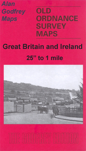
19th and early 20th century. The plans have been taken from the Ordnance Survey mapping and reprinted at about 15 inches to one mile (1:4, 340). On the reverse most maps have historical notes and many also include extracts from contemporary directories. Most maps cover about one mile (1.6kms) north/south, one and a half miles (2.4kms) across; adjoining sheets can be combined to provide wider coverage.FOR MORE INFORMATION AND A COMPLETE LIST OF ALL AVAILABLE TITLES PLEASE CLICK ON THE SERIES LINK.
RIP - This product is no longer available on our network. It was last seen on 25.09.2019

This page now acts as a permanent archive for this product. Add more information using the comments box below to ensure it can still be found by future generations.

Use our search facility to see if it is available from an alternative contributor.
  • External links may include paid for promotion
  • Availability: Out Of Stock
  • Supplier: Stanfords
  • SKU: 9781841513584
Availability: In Stock
£3.50

Product Description

Looe in 1905 in a fascinating series of reproductions of old Ordnance Survey plans in the Alan Godfrey Editions, ideal for anyone interested in the history of their neighbourhood or family. The map covers both West Looe & East Looe, & extends northward to Shutta & Barbican, & eastward to Millendreath Beach. Features include the railway station with the line to the harbour, St Mary`s church, Guildhall, Plaidy Beach, site of St Anne`s chapel, Boscarn House, St Nicholas church; the cramped houses are neatly delineated on either side of the harbour. On the reverse is a directory of Looe in 1910. About the Alan Godfrey Editions of the 25” OS Series Selected towns in Great Britain & Ireland are covered by maps showing the extent of urban development in the last decades of the 19th & early 20th century. The plans have been taken from the Ordnance Survey mapping & reprinted at about 15 inches to one mile (1:4, 340). On the reverse most maps have historical notes & many also include extracts from contemporary directories. Most maps cover about one mile (1.6kms) north/south, one & a half miles (2.4kms) across; adjoining sheets can be combined to provide wider coverage.FOR MORE INFORMATION & A COMPLETE LIST OF ALL AVAILABLE TITLES PLEASE CLICK ON THE SERIES LINK.

Reviews/Comments

Add New

Price History

Vouchers

No voucher codes found.
Do you know a voucher code for this product or supplier? Add it to Insights for others to use.

Facebook

Jargon Buster

Contemporary - Modern era design
Contemporary - A design reference to indicate post war modern design
Beach - An area on the coast consisting of a sandy or pebbled area
History - Anything that happens in the past. An acedemic subject.
Contemporary - An object that is living in the same time.
Ideal - Something that satisfies a perfect criteria.
Family - A group of people that live together made up from parents and children.

Supplier Information

Stanfords
Stanfords was established in 1853 and opened their iconic Covent Garden flagship store in 1901. They have become the top retailer of maps, travel books and accessories in the UK and arguably offer the largest selection of maps and travel books worldwide. Famous names such as Captain Robert Falcon Scott, Ranulph Fiennes and Michael Palin have purchased from Stanfords. They now have a shop in Bristol and both stores together with other venues operate a calendar of events including talks, book signings and exhibitions. As a specialist map retailer, the map selection is comprehensive and includes road maps, street maps and walking maps from worldwide destinations, as well as a selection of world atlases and wall maps. Books include travel guides and travel literature. Stanfords also stock globes, from miniatures made of blue marble to magnificent floor-standing globes. The website features a selection of interesting articles on travel topics.
Page Updated: 2023-11-12 20:15:36

Community Generated Product Tags

Oh No! The productWIKI community hasn't generated any tags for this product yet!
Menu