
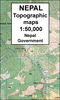
 United Kingdom
 France
 Germany
 Netherlands
 Sweden
 USA
USA
 Italy
Italy
 Spain
Spain
More From Contributor

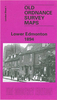
Lower Irlam And Cadishead 1926
Lower Irlam and Cadishead in 1926 in a fascinating series of reproductions of old Ordnance Survey plans in the Alan Godfrey Editions, ideal for anyone interested in the history of their neighbourhood or family. The map covers Lower Irlam, with coverage running along the Liverpool Road towards Cadishead; Green Lane and Lords Street are at the foot of the map. The major feature on the map is the massive Partington Steel & Iron Works with its many sidings, and the map also has a stretch of the Manchester Ship Canal with sidings leading to wharves or bunkering facilities. Other features include stretches of the Cheshire Lines Railway with Irlam and Cadishead stations, Glazebrook Exchange Sidings, Glazebrook Hall, St Mary`s church, Wallpaper works, engineering works, Higher Stanley
Bank Farm, other farms along Moss Road, etc. On the reverse are 1918 directories for Irlam, Cadishead and Chat Moss.About the Alan Godfrey Editions of the 25” OS Series:Selected towns in Great Britain and Ireland are covered by maps showing the extent of urban development in the last decades of the 19th and early 20th century. The plans have been taken from the Ordnance Survey mapping and reprinted at about 15 inches to one mile (1:4, 340). On the reverse most maps have historical notes and many also include extracts from contemporary directories. Most maps cover about one mile (1.6kms) north/south, one and a half miles (2.4kms) across; adjoining sheets can be combined to provide wider coverage.FOR MORE INFORMATION AND A COMPLETE LIST OF ALL AVAILABLE TITLES PLEASE CLICK ON THE
SERIES LINK.

Product Description
Reviews/Comments
Add New
Vouchers
No voucher codes found.
Do you know a voucher code for this product or supplier? Add it to Insights for others to use.
Do you know a voucher code for this product or supplier? Add it to Insights for others to use.
 Denmark