
 United Kingdom
 France
 Germany
 Netherlands
 Sweden
 USA
USA
 Italy
Italy
 Spain
Spain
More From Contributor


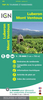

Luberon Parc Naturel Régional IGN Map
Parc Naturel Régional du Luberon at 1:60, 000 from the IGN on a map designed to highlight its places of interest and recreational possibilities, including the GR hiking trails and the Le Luberon a vélo cycling routes. Topography of the park is shown by contours at 50m intervals, enhanced by relief shading and colouring indicating different types of vegetation. Road network includes local roads and country tracks. An overprint highlights GR and GRP long-distance hiking trails, plus the course of Le Luberon a vélo cycling route. Symbols indicate locations of information centres, museums and other cultural sites, selling points of local produce (wine, olive oil, farmers’ markets, etc) and various recreational sites. The map has no geographical coordinates. The map is surrounded
by descriptions local sites. Map legend and all the text are in French. Currenr edition of this map was published in May 2012.PLEASE NOTE: please click on the series link to see the list of other currently available titles in this series of recreational maps from the IGN, plus advice from Stanfords on the best coverage of France by hiking maps from other publishers.
by descriptions local sites. Map legend and all the text are in French. Currenr edition of this map was published in May 2012.PLEASE NOTE: please click on the series link to see the list of other currently available titles in this series of recreational maps from the IGN, plus advice from Stanfords on the best coverage of France by hiking maps from other publishers.
Product Description
Reviews/Comments
Add New
Vouchers
No voucher codes found.
Do you know a voucher code for this product or supplier? Add it to Insights for others to use.
Do you know a voucher code for this product or supplier? Add it to Insights for others to use.
 Denmark