More From Contributor

£10.39
Map No. 188, Maidstone & Royal Tunbridge Wells, in a waterproof & tear-resistant version of the Ordnance Survey Landranger series at 1:50, 000, including Sevenoaks, Tonbridge, Crowborough, Duddleswell, Rotherfield, Mayfield, Wadhurst, Ticehurst, Hurst Green, Bodiam, Sandhurst, Hawkhurst, Rolveden, Cranbook, Biddenden, Goudhurst, Horsmonden, Lamberhurst, Groombridge, Hartfield, Cowden, Leigh, Hildenborough, Hadlow, Goathurst Common, Sundridge, Paddock Wood, Marden, Headcorn, Sutton Valence, Wateringbury, Loose, Hollingbourne, Yalding, Ditton, West Malling, Wrotham, Bredhurst, Snodl&, West Kingsdown, & Halstead. The map also covers the High Weald, Bewl Water & Bough Beech reservoirs, & part of the North Downs Way (European E2 long-distance path). Edition C4; Publication date June 2010 This title is also available on our website in a paper version. Maps in this series are only published folded. Stanfords can also print flat versions of Ordnance Survey maps through the OS Select system, centring the map on a location of your choice & with a picture provided by you on the cover. For more information please click on the link at the bottom of this description. About Ordnance Survey ...
Archived Product
£3.50
Maidstone North in 1866 in a fascinating series of reproductions of old Ordnance Survey plans in the Alan Godfrey Editions, ideal for anyone interested in the history of their neighbourhood or family. The map covers the area from Summerfield Terrace eastward to Gallows Wood & Huntsman Farm, & from Earl Street & Holy Trinity church northward to Medway Paper Mill & Thornhills. The County Gaol is a major feature by default, for it is left blank for security reasons. Depicted features include Perseverance Foundry, Sittingbourne Road, Union Street, Brewer Street, St Faith`s Street, Sandling Road, a stretch of the Medway, Perry Fields, numerous quarries & brickfields, Cavalry Barracks, Springfield Mills, Heathfield House. A stretch of the North Kent Railway is shown, but the Sevenoaks & Maidstone Railway is `under construction`. On the reverse is a commercial directory A to K (continued on the Maidstone South map). About the Alan Godfrey Editions of the 25” OS Series Selected towns in Great Britain & Ireland are covered by maps showing the extent of urban development in the last decades of the 19th & early 20th century. The plans have been taken from the Ordnance Survey mapping & reprinted at about 15 inches to one mile (1:4, 340). On the reverse most maps have historical notes & many also include extracts from contemporary directories. Most maps cover about one mile (1.6kms) north/south, one & a half miles (2.4kms) across; adjoining sheets can be combined to provide wider coverage.FOR MORE INFORMATION & A COMPLETE LIST OF ALL AVAILABLE TITLES PLEASE CLICK ON THE SERIES LINK. ...
Archived Product
£3.50
Maidstone South in 1868 in a fascinating series of reproductions of old Ordnance Survey plans in the Alan Godfrey Editions, ideal for anyone interested in the history of their neighbourhood or family. The map covers the area to the south from King Street & High Street to a milestone marking One Mile from town. Tovil is in the south-western corner, including St Peter`s church, & corn, paper & oil mills. Principal features in Maidstone include All Saints church, Stone Street, Wrens Cross, King Street, Ashford Road, Knightrider Street & Kingsley Estate. West of the Medway are Tunbridge Road, part of The Fant, & the North Kent (SER) Railway with station. The map

Includes::
the rest of the commercial directory, K to Z (continued from the Maidstone map). About the Alan Godfrey Editions of the 25” OS Series Selected towns in Great Britain & Ireland are covered by maps showing the extent of urban development in the last decades of the 19th & early 20th century. The plans have been taken from the Ordnance Survey mapping & reprinted at about 15 inches to one mile (1:4, 340). On the reverse most maps have historical notes & many also include extracts from contemporary directories. Most maps cover about one mile (1.6kms) north/south, one & a half miles (2.4kms) across; adjoining sheets can be combined to provide wider coverage.FOR MORE INFORMATION & A COMPLETE LIST OF ALL AVAILABLE TITLES PLEASE CLICK ON THE SERIES LINK.

...
Archived Product
£4.50
Street by Street Maidstone, Rochester, Chatham Midi has been fully updated with a stylish new cover design, in a handy glovebox size. Quick to navigate & easy-to-use, the maps clearly show AA recommended restaurants, pubs, hotels, one-way streets & car parks. Featuring a clever use of colour to ensure it can be read under street lighting, & National Grid referencing, Street by Street Maidstone, Rochester, Chatham Midi is all you need to keep you on the move. ...
Archived Product
£14.99
Maidstone, Tunbridge Wells & the High Weald area, including a section of the North Downs Way / E2 European Long-distance Path, on a waterproof & tear-resistant OS Active version of map No. 188 from the Ordnance Survey’s Landranger series at 1:50, 000, with contoured & GPS compatible topographic mapping plus tourist information.MOBILE DOWNLOADS: As well as the physical edition of the map, each Landranger title now

Includes::
a code for downloading after purchase its digital version onto your smartphone or tablet for viewing on the OS smartphone app.OS LANDRANGER SERIES: to see the list of all the titles in the OS Landranger series, both paper & waterproof versions, please click on the series link. Maps in the Landranger series provide plenty of recreational & tourist information, indicating the traditional public right of way paths (except in Scotland where different laws apply), including bridleways & byways restricted or open to motorized traffic. National Trails & selected other long-distance paths are marked, as well as on-road & traffic-free cycle routes with their National/ Regional Cycle Network numbers. National Trust/ National Trust for Scotland & Forestry Commission land is clearly marked, indicating open or restricted access. A range of symbols highlights camping & caravanning sites, youth hostels, tourist information offices & visitors’ centres, parking & picnicking places, World Heritage sites, sport & recreational facilities, etc. The maps provide detailed presentation of topography with contours at 10m intervals, numerous spot heights & additional colouring and/or graphics for different types of woodlands, orchards or parkl&, rock features including scree & cliffs, water features inland & along the sea shore with marshl&, dunes, s&, mud, shingle & the high water mark. All the standard information expected of survey mapping at this scale is included: finely graded road network, railway lines with stations, cuttings, embankments, etc; individual isolated buildings; archaeological & historical sites, etc. For GPS users the British National Grid is shown at 1km intervals, with latitude & longitude given by margin ticks at 1` & cross hairs on the map at 5`. Each map covers an area of 40 x 40km, (approx. 25 x 25 miles).

...
Archived Product
£6.99
This is a new translation of this gripping novel which sees the inspector brought out of his peaceful retirement, book nineteen in the new Penguin Maigret series. Maigret shrugged his shoulders, buried his hands in his pockets & went off without answering. He had just spent one of the most wretched days in his life. For hours, in his corner he had felt old & feeble, without idea or incentive. But now a tiny flame flickered. ` You bet we`ll see` he growled. Maigret`s peaceful retirement in the countryside is disrupted when a relative unwittingly embroils himself in a crime he did not commit & the inspector returns to Police Headquarters in Paris once again. Penguin is publishing the entire series of Maigret novels in new translations. This novel has been published in a previous translation as Maigret Returns. ” Compelling, remorseless, brilliant.” (John Gray). ” One of the greatest writers of the twentieth century... Simenon was unequalled at making us look inside, though the ability was masked by his brilliance at absorbing us obsessively in his stories.” (Guardian). ”A supreme writer...unforgettable vividness.” (Independent). Georges Simenon was born in Liege, Belgium, in 1903. Best known in Britain as the author of the Maigret books, his prolific output of over 400 novels & short stories have made him a household name in continental Europe. He died in 1989 in Lausanne, Switzerl&, where he had lived for the latter part of his life. ...
Archived Product
£7.99
Maigret & his fellow inspector Lognon find themselves trying to out-manoeuver each other when they investigate the case of a mysterious young woman whose new life in Paris is tragically cut short. Maigret wouldn`t have admitted that what intrigued him most was the victim`s face. All he had seen of it so far was one profile. Was it the bruises that gave her that sullen air? She looked like a bad-tempered little girl. Her combed-back brown hair was very smooth but naturally wavy. The rain had diluted her make-up a little &, instead of making her older or uglier, it made her younger & more appealing. Penguin is publishing the entire series of Maigret novels in new translations. ` His artistry is supreme` John Banville ` One of the greatest writers of the twentieth century.. . Simenon was unequalled at making us look inside, though the ability was masked by his brilliance at absorbing us obsessively in his stories` Guardian ...
Archived Product
£7.99
A retired manufacturer has been shot dead by his own pistol, last seen alive by his son-in-law. In this seemingly motiveless murder, Inspector Maigret must rely on his famous intuition to discover the truth. Penguin is publishing the entire series of Maigret novels in new translations. This novel has been published in a previous translation as Maigret & the Black Sheep.` His artistry is supreme` John Banville` One of the greatest writers of the twentieth century... Simenon was unequalled at making us look inside, though the ability was masked by his brilliance at absorbing us obsessively in his stories` Guardian ...
Archived Product
£7.99
When a man`s headless body is pulled from the Canal Saint Martin, Maigret & his colleagues are puzzled. In a chance encounter at a local cafe Maigret uncovers the truth behind this disturbing murder in an intriguing story of an estranged family, adulterous affairs & a secret inheritance. Penguin is publishing the entire series of Maigret novels in new translations.` His artistry is supreme` John Banville` One of the greatest writers of the twentieth century... Simenon was unequalled at making us look inside, though the ability was masked by his brilliance at absorbing us obsessively in his stories` Guardian` Penguin is publishing the entire series of Maigret novels in new translations.` His artistry is supreme` John Banville` One of the greatest writers of the twentieth century... Simenon was unequalled at making us look inside, though the ability was masked by his brilliance at absorbing us obsessively in his stories` Guardian ...
Archived Product
£7.99
Set against a high-profile hunt for the latest criminal gang to hit Paris, Maigret is determined to track down the murderer of a quiet crook for whom he cannot help feeling affection & respect. Penguin is publishing the entire series of Maigret novels in new translations. This novel has been published in a previous translation as Maigret & the Idle Burglar. ` His artistry is supreme` John Banville` One of the greatest writers of the twentieth century... Simenon was unequalled at making us look inside, though the ability was masked by his brilliance at absorbing us obsessively in his stories` Guardian ...
Archived Product

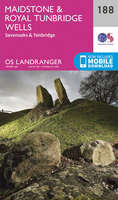
Maidstone, Royal Tunbridge Wells, Sevenoaks & Tonbridge OS
Landranger Map 188 (paper)

Maidstone, Tunbridge Wells and the High Weald area, including a section of the North Downs Way / E2 European Long-distance Path, on a paper version of map No. 188 from the Ordnance Survey’s Landranger series at 1:50, 000, with contoured and GPS compatible topographic mapping plus tourist information.MOBILE DOWNLOADS: As well as the physical edition of the map, each Landranger title now includes a code for downloading after purchase its digital version onto your smartphone or tablet for viewing on the OS smartphone app.OS LANDRANGER SERIES: to see the list of all the titles in the OS Landranger series, both paper and waterproof versions, please click on the series link.Maps in the Landranger series provide plenty of recreational and tourist information, indicating the traditional
public right of way paths (except in Scotland where different laws apply), including bridleways and byways restricted or open to motorized traffic. National Trails and selected other long-distance paths are marked, as well as on-road and traffic-free cycle routes with their National/Regional Cycle Network numbers. National Trust/National Trust for Scotland and Forestry Commission land is clearly marked, indicating open or restricted access. A range of symbols highlights camping and caravanning sites, youth hostels, tourist information offices and visitors’ centres, parking and picnicking places, World Heritage sites, sport and recreational facilities, etc. The maps provide detailed presentation of topography with contours at 10m intervals, numerous spot heights and additional
colouring and/or graphics for different types of woodlands, orchards or parkland, rock features including scree and cliffs, water features inland and along the sea shore with marshland, dunes, sand, mud, shingle and the high water mark. All the standard information expected of survey mapping at this scale is included: finely graded road network, railway lines with stations, cuttings, embankments, etc; individual isolated buildings; archaeological and historical sites, etc. For GPS users the British National Grid is shown at 1km intervals, with latitude and longitude given by margin ticks at 1` and cross hairs on the map at 5`. Each map covers an area of 40 x 40km, (approx. 25 x 25 miles).
RIP - This product is no longer available on our network. It was last seen on 25.09.2019

This page now acts as a permanent archive for this product. Add more information using the comments box below to ensure it can still be found by future generations.

Use our search facility to see if it is available from an alternative contributor.
  • External links may include paid for promotion
  • Availability: Out Of Stock
  • Supplier: Stanfords
  • SKU: 9780319262863
Availability: In Stock
£8.99

Product Description

Maidstone, Tunbridge Wells & the High Weald area, including a section of the North Downs Way / E2 European Long-distance Path, on a paper version of map No. 188 from the Ordnance Survey’s Landranger series at 1:50, 000, with contoured & GPS compatible topographic mapping plus tourist information.MOBILE DOWNLOADS: As well as the physical edition of the map, each Landranger title now

Includes::
a code for downloading after purchase its digital version onto your smartphone or tablet for viewing on the OS smartphone app.OS LANDRANGER SERIES: to see the list of all the titles in the OS Landranger series, both paper & waterproof versions, please click on the series link. Maps in the Landranger series provide plenty of recreational & tourist information, indicating the traditional public right of way paths (except in Scotland where different laws apply), including bridleways & byways restricted or open to motorized traffic. National Trails & selected other long-distance paths are marked, as well as on-road & traffic-free cycle routes with their National/ Regional Cycle Network numbers. National Trust/ National Trust for Scotland & Forestry Commission land is clearly marked, indicating open or restricted access. A range of symbols highlights camping & caravanning sites, youth hostels, tourist information offices & visitors’ centres, parking & picnicking places, World Heritage sites, sport & recreational facilities, etc. The maps provide detailed presentation of topography with contours at 10m intervals, numerous spot heights & additional colouring and/or graphics for different types of woodlands, orchards or parkl&, rock features including scree & cliffs, water features inland & along the sea shore with marshl&, dunes, s&, mud, shingle & the high water mark. All the standard information expected of survey mapping at this scale is included: finely graded road network, railway lines with stations, cuttings, embankments, etc; individual isolated buildings; archaeological & historical sites, etc. For GPS users the British National Grid is shown at 1km intervals, with latitude & longitude given by margin ticks at 1` & cross hairs on the map at 5`. Each map covers an area of 40 x 40km, (approx. 25 x 25 miles).

Reviews/Comments

Add New

Intelligent Comparison

Oooops!
We couldn't find anything!
Perhaps this product's unique.... Or perhaps we are still looking for comparisons!
Click to bump this page and we'll hurry up.

Price History

Vouchers

No voucher codes found.
Do you know a voucher code for this product or supplier? Add it to Insights for others to use.

Facebook

Jargon Buster

GPS - Global Positioning System - Global position using satellites
Paper - A thin sheet mainly used for writing. Available in a variety of colours. Made mainly from wood pulp.
Digital - A system that uses only 0s and 1s to transmit data
water - A chemical substance. Chemical formula H2O.
Graphics - A general term for visual aspects of an item/display
Physical - Used to describe strength or visual properties of an item
Waterproof - Resistant to water, usualy specified by depth in metres
Mud - A combination of water and soil/clay/silt. Oftern brown in colour
World - A physical grouping, commonly used to describe earth and everything associated with ti
Network - A link and communication between things. Often computers or people.
Road - a manmade lane or a path that is used to speed up travel.
Traditional - Something that has become the same through a period of time and thus repeated.
Traditional - Something that has been around for a while and is repeated regularly.
Regional - An adjective to describe a set geographic area.
Individual - A single separate item or person.

Supplier Information

Stanfords
Stanfords was established in 1853 and opened their iconic Covent Garden flagship store in 1901. They have become the top retailer of maps, travel books and accessories in the UK and arguably offer the largest selection of maps and travel books worldwide. Famous names such as Captain Robert Falcon Scott, Ranulph Fiennes and Michael Palin have purchased from Stanfords. They now have a shop in Bristol and both stores together with other venues operate a calendar of events including talks, book signings and exhibitions. As a specialist map retailer, the map selection is comprehensive and includes road maps, street maps and walking maps from worldwide destinations, as well as a selection of world atlases and wall maps. Books include travel guides and travel literature. Stanfords also stock globes, from miniatures made of blue marble to magnificent floor-standing globes. The website features a selection of interesting articles on travel topics.
Page Updated: 2023-11-12 20:15:36

Community Generated Product Tags

Oh No! The productWIKI community hasn't generated any tags for this product yet!
Menu