More From Contributor

£14.99
Old maps provide a rich source of information & insight for all those interested in the history of their locality, including local historians, geographers & cartographers. They are also a popular field for collectors & they fascinate many others. They abound in record offices & archives & are frequently to be found on sale in antique shops. This book represents a comprehensive guide to their provenance, content, accuracy, location & uses. Now in its 2nd edition, it has over 100 illustrations to support the text, including examples of every type of map discussed. The author also uses illustrations to demonstrate the rich variety of ways in which maps represent a source of historical evidence. ...
Archived Product
£8.99
In an unnamed town Jugnu & his lover Chanda have disappeared. Rumours abound in the close-knit Pakistani community, & then on a snow-covered January morning Chanda`s brothers are arrested for murder. Telling the story of the next twelve months, Maps for Lost Lovers opens the heart of a family at the crossroads of culture, community, nationality & religion, & expresses their pain in a language that is arrestingly poetic. ” This is a deeply pastoral novel, tied to the seasons & resonating with birdsong... Like Aslam, I was heartbroken when the dense, dark tapestry was finished”. (Independent on Sunday). ” Despite the violence that lies at the heart of the novel, it is a celebration of love & life. Sights & sounds, smells & colours are not so much vivid backdrops for the narrative as structural, mood- & texture-enhancing parts of it... This is that rare sort of book that gives a voice to those voices that are seldom heard”. (Observer). ...
Archived Product
£220.00
Framed, 136 x 100cm (4ft 5’’ x 3ft 4’’ approx.) version of the large political map of the world from Maps International mounted on *magnetic board* to which magnetic makers can be attached. Countries are shown in bright vivid colours against light blue oceans. Country names are in large, clearly legible print. English versions of all city names are used throughout. Within USA, Canada & Brazil internal state or provincial boundaries are indicated. Central Pacific, from Alaska/ Siberia to New Zeal&, is repeated on both sides of the map for better presentation of that region. The map has well designed relief shading to show the mountainous areas like the Rockies or the Andes, enhancing the overall presentation. The colouring of the oceans also shows different depths. Projection is Van der Grinten. Clocks show time difference from GMT (but without the map indicating the exact geographical area covered by each time zone). A decorative panel under the map displays flags of various countries.* This 1:30, 000, 000 map is also available on paper, encapsulated, laminated & with hanging strips, or framed & mounted on pin board, & can be supplied on magnetic board at reduced height, without the panel of flags. The same design is also available in a larger size & in two smaller formats
- please click on the link above to see the full list of currently available titles.* Magnetic Markers: please enter `magnetic markers` in the search box above to see our range of colours.* These magnetic board maps are produced on dem&. Please get in touch with us for more information.
...
Archived Product
£219.00
Smaller version of the framed & mounted on magnetic board, large political map of the world from Maps International, with its size reduced to 136 x 86cm (4ft 5’’ x 2ft 10” approx.) by removing the decorative panel of flags under the map. Countries are shown in bright vivid colours against light blue oceans. Country names are in large, clearly legible print. English versions of all city names are used throughout. Within USA, Canada & Brazil internal state or provincial boundaries are indicated. Central Pacific, from Alaska/ Siberia to New Zeal&, is repeated on both sides of the map for better presentation of that region. The map has well designed relief shading to show the mountainous areas like the Rockies or the Andes, enhancing the overall presentation. The colouring of the oceans also shows different depths. Projection is Van der Grinten. Clocks show time difference from GMT (but without the map indicating the exact geographical area covered by each time zone). The decorative panel of flags displayed in other versions of this map has been removed to reduce the height.* This 1:30, 000, 000 map is also available on paper, encapsulated, laminated & with hanging strips, or framed mounted on pin board, & can be supplied on magnetic board retaining its decorative panel of flags. The same design is also available in a larger size or in two smaller formats
- please click on the link above to see the full list of currently available titles.* Magnetic Markers: please enter `magnetic markers` in the search box above to see our range of colours.* These magnetic board maps are produced on dem&. Please get in touch with us for more information.
...
Archived Product
£199.00
Framed, 136 x 100cm (4ft 5’’ x 3ft 4’’ approx.) version of the large political map of the world from Maps International mounted on *pin board*. Countries are shown in bright vivid colours against light blue oceans. Country names are in large, clearly legible print. English versions of all city names are used throughout. Within USA, Canada & Brazil internal state or provincial boundaries are indicated. Central Pacific, from Alaska/ Siberia to New Zeal&, is repeated on both sides of the map for better presentation of that region. The map has well designed relief shading to show the mountainous areas like the Rockies or the Andes, enhancing the overall presentation. The colouring of the oceans also shows different depths. Projection is Van der Grinten. Clocks show time difference from GMT (but without the map indicating the exact geographical area covered by each time zone). A decorative panel under the map displays flags of various countries.* This 1:30, 000, 000 map is also available on paper, encapsulated, laminated & with hanging strips, or framed & mounted on magnetic board, & can also be supplied on pin board at reduced height, without the panel of flags. The same design is also available in a larger size & in two smaller formats
- please click on the link above to see the full list of currently available titles.
...
Archived Product
£180.00
Framed, 103 x 72cm (3ft 4’’ x 2ft 4’’ approx.) version of the medium size political map of the world from Maps International mounted on *magnetic board* to which magnetic makers can be attached. Countries are shown in bright vivid colours against light blue oceans. Country names are in large, clearly legible print. English versions of all city names are used throughout. Within USA, Canada & Brazil internal state or provincial boundaries are indicated. Central Pacific, from Alaska/ Siberia to New Zeal&, is repeated on both sides of the map for better presentation of that region. The map has well designed relief shading to show the mountainous areas like the Rockies or the Andes, enhancing the overall presentation. The colouring of the oceans also shows different depths. Projection is Van der Grinten. Clocks show time difference from GMT (but without the map indicating the exact geographical area covered by each time zone). A decorative panel under the map displays flags of various countries.* This 1:40, 000, 000 map is also available on paper, encapsulated, laminated & with hanging strips, or framed & mounted on pin board, & can be supplied on magnetic board at reduced height, without the panel of flags. The same design is also available in two larger sizes & in a smaller format
- please click on the link above to see the full list of currently available titles.* Magnetic Markers: please enter `magnetic markers` in the search box above to see our range of colours.* These magnetic board maps are produced on dem&. Please get in touch with us for more information.
...
Archived Product
£142.95
Smaller version of the framed & mounted on magnetic board, medium size political map of the world from Maps International, with its size reduced to 103 x 62cm (3ft 4’’ x 2ft approx.) by removing the decorative panel of flags under the map. Countries are shown in bright vivid colours against light blue oceans. Country names are in large, clearly legible print. English versions of all city names are used throughout. Within USA, Canada & Brazil internal state or provincial boundaries are indicated. Central Pacific, from Alaska/ Siberia to New Zeal&, is repeated on both sides of the map for better presentation of that region. The map has well designed relief shading to show the mountainous areas like the Rockies or the Andes, enhancing the overall presentation. The colouring of the oceans also shows different depths. Projection is Van der Grinten. Clocks show time difference from GMT (but without the map indicating the exact geographical area covered by each time zone). The decorative panel of flags displayed in other versions of this map has been removed to reduce the height.* This 1:40, 000, 000 map is also available on paper, encapsulated, laminated & with hanging strips, or framed mounted on pin board, & can be supplied on magnetic board retaining its decorative panel of flags. The same design is also available in two larger sizes & in a smaller format
- please click on the link above to see the full list of currently available titles.* Magnetic Markers: please enter `magnetic markers` in the search box above to see our range of colours.* These magnetic board maps are produced on dem&. Please get in touch with us for more information.
...
Archived Product
£149.99
Framed, 103 x 72cm (3ft 4’’ x 2ft 4’’ approx.) version of the medium size political map of the world from Maps International mounted on *pin board*. Countries are shown in bright vivid colours against light blue oceans. Country names are in large, clearly legible print. English versions of all city names are used throughout. Within USA, Canada & Brazil internal state or provincial boundaries are indicated. Central Pacific, from Alaska/ Siberia to New Zeal&, is repeated on both sides of the map for better presentation of that region. The map has well designed relief shading to show the mountainous areas like the Rockies or the Andes, enhancing the overall presentation. The colouring of the oceans also shows different depths. Projection is Van der Grinten. Clocks show time difference from GMT (but without the map indicating the exact geographical area covered by each time zone). A decorative panel under the map displays flags of various countries.* This 1:40, 000, 000 map is also available on paper, encapsulated, laminated & with hanging strips, or framed & mounted on magnetic board, & can be supplied on pin board at reduced height, without the panel of flags. The same design is also available in two larger sizes & in a smaller format
- please click on the link above to see the full list of currently available titles.
...
Archived Product
£124.95
Smaller version of the framed & mounted on pin board, medium size political map of the world from Maps International, with its size reduced to 103 x 62cm (3ft 4’’ x 2ft approx.) by removing the decorative panel of flags under the map. Countries are shown in bright vivid colours against light blue oceans. Country names are in large, clearly legible print. English versions of all city names are used throughout. Within USA, Canada & Brazil internal state or provincial boundaries are indicated. Central Pacific, from Alaska/ Siberia to New Zeal&, is repeated on both sides of the map for better presentation of that region. The map has well designed relief shading to show the mountainous areas like the Rockies or the Andes, enhancing the overall presentation. The colouring of the oceans also shows different depths. Projection is Van der Grinten. Clocks show time difference from GMT (but without the map indicating the exact geographical area covered by each time zone). The decorative panel of flags displayed in other versions of this map has been removed to reduce the height.* This 1:40, 000, 000 map is also available on paper, encapsulated, laminated & with hanging strips, or framed mounted on magnetic board, & can be supplied on pin board retaining its decorative panel of flags. The same design is also available in two larger sizes & in a smaller format
- please click on the link above to see the full list of currently available titles.
...
Archived Product
£23.99
Laminated & with hanging strips, 69.5 x 53.5cm (27” x 21” approx.), version of the small political map of the world from Maps International. The map is supplied with high quality metal hanging strips in dark blue colour, making it very easy to hang on a wall. It is laminated on both sides of the paper to make it damp-proof & can be written on with suitable marker pens without any damage to the map surface. Countries are shown in bright vivid colours against light blue oceans. Country names are in large, clearly legible print. English versions of all city names are used throughout. Within USA, Canada & Brazil internal state or provincial boundaries are indicated. Central Pacific, from Alaska/ Siberia to New Zeal&, is repeated on both sides of the map for better presentation of that region. The map has well designed relief shading to show the mountainous areas like the Rockies or the Andes, enhancing the overall presentation. The colouring of the oceans also shows different depths. Projection is Van der Grinten. Clocks show time difference from GMT (but without the map indicating the exact geographical area covered by each time zone). A decorative panel under the map displays flags of various countries.* This 1:60, 000, 000 map is also available on paper, encapsulated or framed mounted either on pin board or magnetic board, & can be supplied with hanging strips at reduced height, without the panel of flags. The same design is also available in three larger sizes
- please click on the link above to see the full list of currently available titles.
...
Archived Product

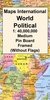
Maps International Political World Wall Map LARGE, PIN BOARD, FRAMED
(without Flags)

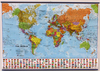
Smaller version of the framed and mounted on pin board, large political map of the world from Maps International, with its size reduced to 136 x 86cm (4ft 5’’ x 2ft 10” approx.) by removing the decorative panel of flags under the map. Countries are shown in bright vivid colours against light blue oceans. Country names are in large, clearly legible print. English versions of all city names are used throughout. Within USA, Canada and Brazil internal state or provincial boundaries are indicated. Central Pacific, from Alaska/Siberia to New Zealand, is repeated on both sides of the map for better presentation of that region.The map has well designed relief shading to show the mountainous areas like the Rockies or the Andes, enhancing the overall presentation. The colouring of the
oceans also shows different depths. Projection is Van der Grinten.Clocks show time difference from GMT (but without the map indicating the exact geographical area covered by each time zone). The decorative panel of flags displayed in other versions of this map has been removed to reduce the height.* This 1:30, 000, 000 map is also available on paper, encapsulated, laminated and with hanging strips, or framed mounted on magnetic board, and can be supplied on pin board retaining its decorative panel of flags. The same design is also available in a larger size and in two smaller formats - please click on the link above to see the full list of currently available titles.
RIP - This product is no longer available on our network. It was last seen on 25.09.2019

This page now acts as a permanent archive for this product. Add more information using the comments box below to ensure it can still be found by future generations.

Use our search facility to see if it is available from an alternative contributor.
  • Availability: Out Of Stock
  • Supplier: Stanfords
  • SKU: XL00000170823
Availability: In Stock
£199.00

Product Description

Smaller version of the framed & mounted on pin board, large political map of the world from Maps International, with its size reduced to 136 x 86cm (4ft 5’’ x 2ft 10” approx.) by removing the decorative panel of flags under the map. Countries are shown in bright vivid colours against light blue oceans. Country names are in large, clearly legible print. English versions of all city names are used throughout. Within USA, Canada & Brazil internal state or provincial boundaries are indicated. Central Pacific, from Alaska/ Siberia to New Zeal&, is repeated on both sides of the map for better presentation of that region. The map has well designed relief shading to show the mountainous areas like the Rockies or the Andes, enhancing the overall presentation. The colouring of the oceans also shows different depths. Projection is Van der Grinten. Clocks show time difference from GMT (but without the map indicating the exact geographical area covered by each time zone). The decorative panel of flags displayed in other versions of this map has been removed to reduce the height.* This 1:30, 000, 000 map is also available on paper, encapsulated, laminated & with hanging strips, or framed mounted on magnetic board, & can be supplied on pin board retaining its decorative panel of flags. The same design is also available in a larger size & in two smaller formats
- please click on the link above to see the full list of currently available titles.

Reviews/Comments

Add New

Intelligent Comparison

Oooops!
We couldn't find anything!
Perhaps this product's unique.... Or perhaps we are still looking for comparisons!
Click to bump this page and we'll hurry up.

Price History

Vouchers

No voucher codes found.
Do you know a voucher code for this product or supplier? Add it to Insights for others to use.

Facebook

Jargon Buster

Paper - A thin sheet mainly used for writing. Available in a variety of colours. Made mainly from wood pulp.
Blue - A primary colour
magnetic - A susbstance affected at a microscopic level by an applied magnetic field.
Brazil - A country in South America
Wall - A physical barrier between two areas
World - A physical grouping, commonly used to describe earth and everything associated with ti
Size - is the measurement of how big an object is in space.
Large - something that takes up more space than normal.
Design - A drawing or styles that shows the look and functionality of something before its made.
Laminated - A thin layer of plastic that gives a coating and shine to a material.
Decorative - Making things look more appealing and attractive.
Print - A mechanical process of putting text onto paper. It can also relate to a pattern on an item.

Supplier Information

Stanfords
Stanfords was established in 1853 and opened their iconic Covent Garden flagship store in 1901. They have become the top retailer of maps, travel books and accessories in the UK and arguably offer the largest selection of maps and travel books worldwide. Famous names such as Captain Robert Falcon Scott, Ranulph Fiennes and Michael Palin have purchased from Stanfords. They now have a shop in Bristol and both stores together with other venues operate a calendar of events including talks, book signings and exhibitions. As a specialist map retailer, the map selection is comprehensive and includes road maps, street maps and walking maps from worldwide destinations, as well as a selection of world atlases and wall maps. Books include travel guides and travel literature. Stanfords also stock globes, from miniatures made of blue marble to magnificent floor-standing globes. The website features a selection of interesting articles on travel topics.
Page Updated: 2023-11-12 20:15:36

Community Generated Product Tags

Oh No! The productWIKI community hasn't generated any tags for this product yet!
Menu