
 United Kingdom
 France
 Germany
 Netherlands
 Sweden
 USA
USA
 Italy
Italy
 Spain
Spain
More From Contributor


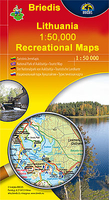
Moletai Lake District
Moletai Lake District in a series of contoured maps at 1:50, 000 from the Vilnius based publishers Briedis covering Lithuania’s popular regions and highlighting each area’s recreational possibilities, tourist facilities, various places of interest, etc. The map provides extensive additional tourist information about the area; the text includes English.Maps in this series are contoured and have colouring and/or graphics to indicate different types of terrain and vegetation, e.g. peat bogs, marshland, forests, cultivated areas, etc. Road network indicates gravel roads and shows locations of petrol stations and car repair workshops. Also marked are field and forest paths. Railway lines are shown with stations. An overprint highlights waymarked hiking paths, cycling routes and
kayaking/canoeing routes over the lakes and rivers. Symbols indicate various tourist facilities (hotels, rest houses, farmhouse accommodation, campsites, etc), cafes, viewpoints, churches and historical buildings, archaeological sites, etc. The maps have no geographical coordinates. Map legend includes English.The reverse side provides additional tourist information. Unless indicated to the contrary in the individual description the text, cross-referenced to the map itself, is in Lithuanian only.
kayaking/canoeing routes over the lakes and rivers. Symbols indicate various tourist facilities (hotels, rest houses, farmhouse accommodation, campsites, etc), cafes, viewpoints, churches and historical buildings, archaeological sites, etc. The maps have no geographical coordinates. Map legend includes English.The reverse side provides additional tourist information. Unless indicated to the contrary in the individual description the text, cross-referenced to the map itself, is in Lithuanian only.

Product Description
Reviews/Comments
Add New
Vouchers
No voucher codes found.
Do you know a voucher code for this product or supplier? Add it to Insights for others to use.
Do you know a voucher code for this product or supplier? Add it to Insights for others to use.
 Denmark