More From Contributor

£34.99
High quality reproduction from the IGN of a beautifully engraved map of the world prepared in 1688 by Jacques Jaugeon, French scholar & royal typographer during the reign of King Louis XIV. The map presents the world in two hemispheres, surrounded by allegorical figures representing the constellations & definitions of geographical terms (meridians, parallels, poles, tropics, the equator, etc.). The corners & the centre are decorated with various artistic representations of the solar system, the phases of the moon, etc. All the text on the map is in French. The map is printed on high quality art paper.PLEASE NOTE: the same map is also available in a coloured version published by the IGN-CNIG, Spain’s Civilian Survey organization (please search for 9788441620063). ...
Archived Product
£45.00
This analogue time zone clock has three independent mechanisms so you can choose which different time zone you want in each face. Great for keeping track of the time in your three favourite destinations & for knowing what hour is an acceptable time to telephone relatives faraway. This clock would be especially useful for travellers or those who liaise with overseas offices. Requires three AA batteries, not included. ...
Archived Product
£18.99
Mondo Enduro is amongst the handful of books that was written with no intention that it should ever be published. The typed up diaries have become a cult adjunct to the pre-existing TV programme of the same name. It was only published as fans of the show clamoured for the 'full' story behind this legendary DIY expedition. Mondo is famous for several reasons least of all being that it was the basis for Ewan Mac Gregor's Long Way Round production. In 2004, when this world famous actor & his entourage drove into Magadan in Russia's remote far eastern Kolimar province there was much celebration but little mention of the fact that they had merely followed a trail blazed by the Mondo Enduro team in August 1995. However, the truth will out & over the years the whisperings on the chat rooms & blogs have risen to a noisy chorus. Everybody loves an underdog & the success of the Mondo boys in the face of their stunning incompetence & unpreparedness has become the stuff of adventure travel folklore. Far from being square-jawed explorers the seven man Mondo team is filled with a superbly bland cross section of nobodies who, with no idea what they are doing, set of to establish a new long distance travel record. The phenomenal underground success of the Mondo story is rooted in the fact that they pulled it off with no sponsorship, backing or internet to fall back on. It's the last great analogue adventure. Being the first people to ride their second hand dirt bikes (no, Suzuki wouldn't even answer their calls, yet alone give them a spare spark plug) from London to Magadan put them in the record books. They then rode from Alaska to the bottom of Chile, then from Johnannesburg back to London, non-stop. Why the rush? Because they wanted to see if it could be done. You couldn't make this stuff up... This is the hardback edition of the book
- the paperback of the same name (9781904466284) is out of print & this edition has 69 extra maps & photos; a new foreword & afterword; &, a complete 'where are they now' epilogue.
...
Archived Product
£6.95
Topographic coverage of mainland Spain at 1:50, 000 in the MTN50 (Mapa Topográfico Nacional) series from the Centro Nacional de Información Geografica, the country’s civilian survey organization. The maps have contours at 20m intervals, enhanced by relief shading, plus colouring and/or graphics to show different types of terrain, vegetation or land use. Boundaries of national parks & other protected areas are marked. In addition to all the usual information featured on topographic mapping at this scale, detailed presentation of the road & rail networks, rural tracks & paths, etc, the maps also show campsites & mountain refuges. On more recent editions some GRs, the official long-distance hiking routes, are also marked (although not as clearly as on hiking maps from other publishers). Each map covers 29.5x 18.5 km (with adjustments in the border or coastal areas). The maps have a 1-km UTM grid, plus margin ticks for latitude & longitude at 1` intervals. Map legend is in Spanish only.HOW TO CHOOSE THE RIGHT 50K MAP: all the titles in CNIG’s 200K Provincial Road Maps series at 1:200, 000 are overprinted with the grid for the 1:50, 000 maps & can be used to see the area covered by each 50K title. TO SEE THE LIST OF TITLES IN THIS SERIES PLEASE CLICK ON THE SERIES LINK.PLEASE NOTE
- MAP TITLES: the grids shown on our website serve both the civilian & the military 1:50, 000 topographic series. Although the areas covered by maps in both series are identical (apart from some border or coastal sheets), occasionally map titles differ – only one title is shown on the grid, usually the military one. In Galicia, the Basque country & in the Catalan speaking areas the tendency now is to use local place names rather than the often better known Castilian ones. Where possible, both versions are included in our titles. Map titles listed on our website are based on information received by us at the time of publication, but sometimes maps arrive showing a completely different title! As long as the map number is as ordered, the correct map has been supplied.
...
Archived Product
£16.99
Val Vermenagna
- Valle Pesio
- Alta Valle Ellero area of the Italian Alps presented at 1:25, 000 in a series of large, contoured

...
Archived Product
£11.99
This journal features striking gold embellishment combined with the look of an old leather journal that has been lovingly used for at least a century. It is made from paper & thick cardboard & the back cover comes up to wrap itself on the front cover with the help of an invisible magnet, thus protecting the pages inside. It has 144 ruled pages, a memento pouch, & a grey ribbon marker. 13x 18cm. ...
Archived Product
£8.99
Now bankrupt after some failed gambles, Aristide Saccard, the former kingpin of the Paris Stock Exchange, desperately wants to get back to the top of the financial pile. When his powerful brother, the government minister Eugene Rougon, refuses to help him, he forms a partnership with the engineer Hamelin & founds the Banque Universelle, which speculates on public works in the Middle East. But as his greed & desire to outplay his rivals gets the better of him, the dashing & ruthless Saccard perilously begins to inflate the value of his enterprise using rumour, intrigue, financial manipulation & all the other tricks in the book. Inspired by real events & meticulously researched by Zola, Money is, in the wake of recent financial scandals, an all-too-topical exploration of the dynamics of greed, the excesses of capitalism & its dangerous relationship with politics & the press. ...
Archived Product
£13.50
Money Belt is an inconspicuous way of safekeeping your money for emergency or loose change situations. The canvas belt looks normal but has a hidden zip pocket on the inside of the waistb&. Waist size is adjustable by a sliding metal buckle & extends to a maximum of 120cm, with a belt width of 3.8cm. ...
Archived Product
£7.99
The Money Belt by Go Travel is a thin wallet you easily hide under your shirt, to keep your money, valuables & small documents safe whilst travelling. made from soft, lightweight fabric, it is comfortable & easy to wear. It features a main large pocket with zip closure & an adjustable belt. Ideal for your travels. ...
Archived Product
£13.50
Money Belt is an inconspicuous way of safekeeping your money for emergency or loose change situations. The canvas belt looks normal but has a hidden zip pocket on the inside of the waistb&. Waist size is adjustable by a sliding metal buckle & extends to a maximum of 120cm, with a belt width of 4 cm. ...
Archived Product

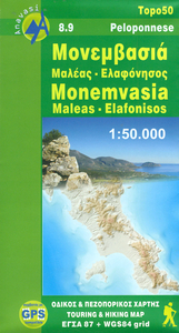
Monemvasia - Maleas - Elafonisos Anavasi 8.9

Monemvasia - Maleas - Elafonisos area, the eastern finger of the Peloponnese and the Elsfonisos Island, at 1:50, 000 in a series of waterproof and tear-resistant hiking maps from Anavasi with a UTM grid for GPS users. On one side is a topographic map of the area with contours at 20m intervals and a 1-km UTM grid. On the reverse a simplified version of the main map highlights 19 recommended hiking routes in the Monemvasia area, plus 14 more trails the southern part of the Maleas Peninsula.Maps in the Anavasi hiking series covering mainland Greece are contoured; interval varies depending on the scale, on most maps it is 20m. Relief shading, spot heights, springs, seasonal streams and, in most titles, landscape/land-use variations, e.g. forests, orchards, or vineyards provide
additional information on the terrain. Place names are given in both Greek and Latin script.Local footpaths, hostels and mountain huts are clearly marked. For road users intermediate driving distances and petrol stations are shown. Symbols highlight places of interest, including archaeological sites, churches and monasteries, etc. The maps have a UTM grid and margin ticks for latitude and longitude. Map legend includes English.
RIP - This product is no longer available on our network. It was last seen on 25.09.2019

This page now acts as a permanent archive for this product. Add more information using the comments box below to ensure it can still be found by future generations.

Use our search facility to see if it is available from an alternative contributor.
  • External links may include paid for promotion
  • Availability: Out Of Stock
  • Supplier: Stanfords
  • SKU: 9789609137980
Availability: In Stock
£8.50

Product Description

Monemvasia
- Maleas
- Elafonisos area, the eastern finger of the Peloponnese & the Elsfonisos Isl&, at 1:50, 000 in a series of waterproof & tear-resistant hiking maps from Anavasi with a UTM grid for GPS users. On one side is a topographic map of the area with contours at 20m intervals & a 1-km UTM grid. On the reverse a simplified version of the main map highlights 19 recommended hiking routes in the Monemvasia area, plus 14 more trails the southern part of the Maleas Peninsula. Maps in the Anavasi hiking series covering mainland Greece are contoured; interval varies depending on the scale, on most maps it is 20m. Relief shading, spot heights, springs, seasonal streams &, in most titles, landscape/l&-use variations, e.g. forests, orchards, or vineyards provide additional information on the terrain. Place names are given in both Greek & Latin script. Local footpaths, hostels & mountain huts are clearly marked. For road users intermediate driving distances & petrol stations are shown. Symbols highlight places of interest, including archaeological sites, churches & monasteries, etc. The maps have a UTM grid & margin ticks for latitude & longitude. Map legend

Includes::
English.

Reviews/Comments

Add New

Intelligent Comparison

Oooops!
We couldn't find anything!
Perhaps this product's unique.... Or perhaps we are still looking for comparisons!
Click to bump this page and we'll hurry up.

Price History

Vouchers

No voucher codes found.
Do you know a voucher code for this product or supplier? Add it to Insights for others to use.

Facebook

Jargon Buster

GPS - Global Positioning System - Global position using satellites
Hiking - An outdoor activity envolving walking in nature
Waterproof - Resistant to water, usualy specified by depth in metres
Km - Kilometre. A unit of measurement equal to 1000 metres.
Road - a manmade lane or a path that is used to speed up travel.
Resistant - Something that can repel against something.

Supplier Information

Stanfords
Stanfords was established in 1853 and opened their iconic Covent Garden flagship store in 1901. They have become the top retailer of maps, travel books and accessories in the UK and arguably offer the largest selection of maps and travel books worldwide. Famous names such as Captain Robert Falcon Scott, Ranulph Fiennes and Michael Palin have purchased from Stanfords. They now have a shop in Bristol and both stores together with other venues operate a calendar of events including talks, book signings and exhibitions. As a specialist map retailer, the map selection is comprehensive and includes road maps, street maps and walking maps from worldwide destinations, as well as a selection of world atlases and wall maps. Books include travel guides and travel literature. Stanfords also stock globes, from miniatures made of blue marble to magnificent floor-standing globes. The website features a selection of interesting articles on travel topics.
Page Updated: 2023-11-12 20:15:36

Community Generated Product Tags

Oh No! The productWIKI community hasn't generated any tags for this product yet!
Menu