
 United Kingdom
 France
 Germany
 Netherlands
 Sweden
 USA
USA
 Italy
Italy
 Spain
Spain
More From Contributor


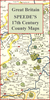
Monmothsire 1848-1852
Monmouthshire, an original antique map by B.Clarke / H.G.Collins, published in London, c. 1848 -1852. A lithograph engraving, coloured. Map size 35 x 41 cm with a mount size of 49.5 x 57.5 cm.A detailed nineteenth-century map of Monmouth that was published in the atlas, The British Gazetteer, Political, Commercial, Ecclesiastical, And Historical.. . in 1852. These lithograph maps bear the imprint of H.G.Collins in Paternoster Row and show accurate geographical detail, including the expanding railway network, surrounded by a floral border. Information also includes the turnpike and mail coach roads as well as parliamentary boundaries and polling places, the seats of the nobility and the gentry, and market towns with their distances from London. The maps are lithographic version
of Robert Rowe's county maps that were published from engraved copperplates between 1814 and 1842. Collins also published these lithograph versions in 1848 in the New British Atlas and they were subsequently reused by Phillips in his County Atlas.. . in the 1860s - their use in a variety of publications is testament to their popularity. Antique maps from various original publishers are presented on the Stanford
of Robert Rowe's county maps that were published from engraved copperplates between 1814 and 1842. Collins also published these lithograph versions in 1848 in the New British Atlas and they were subsequently reused by Phillips in his County Atlas.. . in the 1860s - their use in a variety of publications is testament to their popularity. Antique maps from various original publishers are presented on the Stanford
Product Description
Reviews/Comments
Add New
Vouchers
No voucher codes found.
Do you know a voucher code for this product or supplier? Add it to Insights for others to use.
Do you know a voucher code for this product or supplier? Add it to Insights for others to use.
 Denmark