More From Contributor
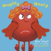
£11.50
Frankenhöhe Regional Park, map no. 50-17 covering an area around Rothenburg ob der Tauber & Ansbach, in a series of special contoured & GP-compatible recreational maps from the Bavarian state survey organization, with cartography of the German topographic survey at 1:50, 000 & extensive additional tourist overprint highlighting waymarked hiking trails & cycling routes, campsites & youth hostels, etc. Maps in this series have cartography identical to the standard topographic survey of Germany. Topography is vividly presented by contours at 20m intervals, enhanced by bold shading & graphic relief, plus colouring and/or graphics to show forests & other types of vegetation. Extensive tourist overprint highlights local & long-distance footpaths & cycle routes
- including King Ludwig Way, different variants of the Way of St James, etc
- indicating, where appropriate, their waymarking designation. Symbols show various types of accommodation (campsites, youth hostels, refuges, etc), sport & recreational facilities, places of interest, ski & cable car lift, etc. The maps have UTM grid lines at 1-km UTM intervals. Map legend &, where included, additional text, are in German only. To see the other titles in this series please click on the series link.

...
Archived Product
£12.99
Naturpark Mass
- Schwalm – Nette in Germany at 1:50, 000 from Kümmerly+ Frey in a series GPS compatible, double-sided maps printed
...
Archived Product
£12.99
Topographic survey of France at 1:25, 000 in IGN`s excellent TOP25 / Série Bleue series. All the maps are GPS compatible, with a 1km UTM grid plus latitude & longitude lines at 5’ intervals. Contours are at 5m intervals except for mountainous areas where the maps have contours at 10m intervals, vividly enhanced by hill shading & graphics for rocky terrain. Colouring with graphics indicates different types of vegetation or land use (deciduous or coniferous forests, moors, orchards, vineyards, etc). PLEASE NOTE: coverage of France at this scale is currently being revised – the format & the presentation of each title are indicated by the letters at the end of its Sheet Reference number (e.g. 0416ET, 3531ETR, 1923SB, etc.)MAPS WITH FULL TOURIST OVERPRINT & AN ENGLISH MAP LEGEND: all TOP25 maps & the SB editions of Série Bleue have an overprint highlighting waymarked walking trails including long-distance GR routes &, where appropriate, ski routes. Symbols indicate campsites, gîtes d’etape, refuges, equestrian centres & other recreational facilities or sites, tourist information centres, cultural heritage, etc. Towns & locations of particular interest are highlighted.- ET or OT = single-sided TOP25 map covering approx. 29x 21 km / 18x 13 miles.- ETR or OTR = waterproof & tear resistant TOP25 map covering the same area as the corresponding ET or OT number, but double-sided, printed on a smaller size sheet with a good overlap between the sides.- SB = Série Bleue map with full tourist overprint; these maps, first introduced in summer 2014, each cover approx. 29x 24km / 18x 15 miles.SÉRIE BLEUE maps with numbers ending in E (Est) or O (Ouest): most editions now indicate the GR routes, but do not show any other tourist information. Map legend is in French only. Each map covers approx. 14x 20km / 9x 12 miles. ...
Archived Product
£12.99
Nauders, map No. 249bis, in the standard topographic survey of Switzerland at 1:50, 000 from Swisstopo, i.e. without the special overprint highlighting walking trails, local bus stops, etc, presented in Swisstopo’s hiking editions of the 50K survey. The map covers mainly the Austrian & the Italian side of the border. Highly regarded for their superb use of graphic relief & hill shading, the maps give an almost 3-D picture of Switzerland`s mountainous terrain. Contours are at 20m intervals. All the maps have a 1-km grid with the Swiss national coordinates. This standard version of the 50K survey covers the whole country on 78 small format sheets, with special larger format maps published for several popular tourist destinations. Small format sheets cover an area of 35 x 24 km (21 x 15 miles approx) & have map legend in the language of the area covered by the map. The special larger sheets cover 50 x 35 km (31 x 22 miles approx) & have no map legend, but a separate leaflet can be provided instead.PLEASE NOTE: the hiking editions of the 1:50, 000 Swisstopo survey are listed on our website in a separate series. ...
Archived Product
£8.95
Containing 21 detachable postcards of miniature scenes in which naughty little people engage in surprising, funny, titillating or simply obscene behaviour, this book gives readers a humorous look beneath the veneer of polite society. Artists Vincent Bousserez, Jonah Samson, Lisa Swerling, Etienne Clement & the Rainbowmonkey make stunning use of miniature scenes to create startling situations & amusing, memorable images. The pictures play with the notions of surprise & hidden drama, inviting the viewer to take a peek into the darkly funny depths of human behaviour
- from the silly & the crude to the disturbing & the mysterious. Ideal for sharing with or sending to friends, this postcard book is an original, fun & amusing gift for grown ups.
...
Archived Product
£9.99
Jean-Paul Sartre`s first published novel, ” Nausea” is both an extended essay on existentialist ideals, & a profound fictional exploration of a man struggling to restore a sense of meaning to his life. This ” Penguin Modern Classics” edition is translated from the French by Robert Baldick with an introduction by James Wood. ” Nausea” is both the story of the troubled life of an introspective historian, Antoine Roquentin, & an exposition of one of the most influential & significant philosophical attitudes of modern times
- existentialism. The book chronicles his struggle with the realisation that he is an entirely free agent in a world devoid of meaning; a world in which he must find his own purpose & then take total responsibility for his choices. A seminal work of contemporary literary philosophy, ” Nausea” evokes & examines the dizzying angst that can come from simply trying to live. Jean-Paul Sartre (1905-1980) was an iconoclastic French philosopher, novelist, playwright &, widely regarded as the central figure in post-war European culture & political thinking. Sartre famously refused the Nobel Prize for literature in 1964 on the grounds that `a writer should not allow himself to be turned into an institution`. His most well-known works, all of which are published by Penguin, include ” The Age of Reason”, ” Nausea” & ” Iron in the Soul”. If you enjoyed ” Nausea”, you might like Albert Camus` ” The Outsider”, also available in ” Penguin Modern Classics”. ” One of the very few successful members of the genre ” Philosophical Novel”...a young man`s tour de force”. (Iris Murdoch).
...
Archived Product
£7.99
Every essential calculation you need for coastal & offshore navigation This book is an aide memoire bringing together in an easy to understand guide all the frequently needed but often forgotten equations & formulae needed by sailors. The format will be the same throughout: the equation followed by a worked example to show how it should be done. Illustrations will be line drawing to help the reader understand what they are doing & why they are doing it. Calculations included are:* Distance to the visual horizon & the radar horizon* Distance off by vertical sextant angle, horizontal sextant angle, bearings & eho ranging* Calculating course made good, course to steer, set & drift of current & speed & direction of true wind* Sailing to weather & Storm avoidance* Calculating speed through water for estimate time on passage, distance sailed, maximum hull speed for a displacement vessel & spacing of knots on log line* Calculating amplitudes & azimuths of sun & stars.* Calculating wave height, wave length, wave period* Measuring degrees converting degrees, minute & seconds to degrees & decimals of degree* Measuring length Converting imperial units to metric & metric to imperial* Measuring mass Converting imperial units to metric & metric to imperial* Measuring speed Converting imperial units to metric & metric to imperial* Measuring Volume Converting imperial units to metric & metric to imperial. This would also include US measures. ...
Archived Product
£6.99
Praise for the previous edition: ` The book`s clear, sequential photographs include all the basics, including bends, splices, & line-handling tips`
- ” Ocean Navigator”. ` Teaches the 20 most useful knots & splices with wonderful step-by-step photographs. Almost every knot is pictured on two facing pages, so the entire sequence is right before you`
- ” The Ensign”. ` More than knots, [this book] is about rope & its uses on boats`
- ” Dockside”. ` Its illustrations on how the knots are tied are among the best I have seen`
- ” Mariner`s Log”. A wet, pitching deck in a 20-knot `breeze` is not the place to realize you`ve forgotten exactly how to tie a reef knot. Whether you need to brush up on your ropework skills or you`re just learning to sail, ” Nautical Knots Illustrated” is your perfect companion. With clear, simple explanations & 295 step-by-step photographs, you`ll easily learn how to tie the 20 most useful knots & splices. The bowline, reef knot, sheet bend, & clove hitch are here, of course, but so are less common gems such as the carrick bend & stevedore knot. Longtime sailors Paul & Arthur Snyder also explain the essentials of smart line handling, including how to coil halyards & sheets, fix winch overrides, tow dinghies, & pick up a mooring, as well as the best ways to handle high-tech rope materials, such as Kevlar & Spectra, in addition to Dacron & nylon.


...
Archived Product
£7.50
For the directionally challenged! Black Colour coded socks to identify Port (red) & Starboard (green). At sea, an emergency can happen at any time, & it is vital that everything aboard can be clearly identified & described. Where `left` & `right` could lead to confusion, `port` & `starboard` are perfectly clear & unambiguous to a seafarer. 80% Cotton. ...
Archived Product
£17.99
The 1:50 000 topographic map gives a more general picture of the ground features than a basic map. It shows settlements, houses, roads, cultivated areas, waterways, cutting areas, mires, rock exposures, & relief. One map sheet covers an area of 30 x 40 km & one centimetre corresponds to 500 metres on the ground. The 1:50, 000 topographic map is also an ideal complement to nautical charts as it provides useful information about the land areas adjacent to waterways. For example, all Finnish sea areas are covered by 1:50 000 topographic map sheets. ...
Archived Product

Naughty Nancy

Here are the Mini Monster Mates, who live in the same monster-land as the award winning Boris, Sid, Wendy and friends. We have already met Ernie, who likes to spot colours; and norman, who cant resist sticking his nose in and counting all kinds of smelly things. Now we meet Naughty Nancy, who finds that friendship is about being nice.
RIP - This product is no longer available on our network. It was last seen on 25.09.2019

This page now acts as a permanent archive for this product. Add more information using the comments box below to ensure it can still be found by future generations.

Use our search facility to see if it is available from an alternative contributor.
  • External links may include paid for promotion
  • Availability: Out Of Stock
  • Supplier: Stanfords
  • SKU: 9781848772861
Availability: In Stock
£3.99

Product Description

Here are the Mini Monster Mates, who live in the same monster-land as the award winning Boris, Sid, Wendy & friends. We have already met Ernie, who likes to spot colours; & norman, who cant resist sticking his nose in & counting all kinds of smelly things. Now we meet Naughty Nancy, who finds that friendship is about being nice.

Reviews/Comments

Add New

Intelligent Comparison

Oooops!
We couldn't find anything!
Perhaps this product's unique.... Or perhaps we are still looking for comparisons!
Click to bump this page and we'll hurry up.

Price History

Vouchers

No voucher codes found.
Do you know a voucher code for this product or supplier? Add it to Insights for others to use.

Facebook

Jargon Buster

Friends - A close associate or a popular US based sitcom about a group of friends

Supplier Information

Stanfords
Stanfords was established in 1853 and opened their iconic Covent Garden flagship store in 1901. They have become the top retailer of maps, travel books and accessories in the UK and arguably offer the largest selection of maps and travel books worldwide. Famous names such as Captain Robert Falcon Scott, Ranulph Fiennes and Michael Palin have purchased from Stanfords. They now have a shop in Bristol and both stores together with other venues operate a calendar of events including talks, book signings and exhibitions. As a specialist map retailer, the map selection is comprehensive and includes road maps, street maps and walking maps from worldwide destinations, as well as a selection of world atlases and wall maps. Books include travel guides and travel literature. Stanfords also stock globes, from miniatures made of blue marble to magnificent floor-standing globes. The website features a selection of interesting articles on travel topics.
Page Updated: 2023-11-12 20:15:36

Community Generated Product Tags

Oh No! The productWIKI community hasn't generated any tags for this product yet!
Menu