More From Contributor

£69.00
Navigation Accidents & their Causes looks at major casualties to illustrate the lessons that can be learned from them & sets out practical ways for those on the bridge to consider risks, plan for them & then take action to avoid them. The authors, drawn from accident investigators, Masters, navigation specialists, pilots & university lecturers from all over the world, detail the need for risk assessment in advance of a voyage, including bridge resource management & passage planning. Situational awareness is highlighted throughout. Each chapter can be read individually, forming a valuable onboard resource. The overall message is that everyone can learn from the mistakes of others & everyone has a part to play in ensuring that training & experience are used effectively to keep vessels safe.IMO Secretary-General Mr Koji Sekimizu said: “ This timely publication from The Nautical Institute should provide a crucial guide for every mariner serving at sea & serve to assist in reducing collisions & groundings.” ...
Archived Product
£60.00
This book may be used for self-study to build navigational skills or as a comprehensive onboard source of reference. The book is broken down into clearly marked sections, making it easy to locate particular information & to follow the various techniques step by step. It is illustrated throughout with colour photographs, diagrams, chart sections & tables. ...
Archived Product
£55.00
Many maritime incidents could have been prevented by the use of a navigationassessment, which, through careful observation, evaluates how the navigation of a ship is being conducted. An effective assessment should take place over several days & provide practical feedback to the bridge team as well as guidance to shore-based management. This handbook provides a step-by-step guide that will enable the assessor to carry out a fair, objective & positive assessment that properly takes into account human element issues. Case studies of maritime accidents & incidents provide valuable learning points. The book is also intended to help mariners understand the assessment process. If it is properly conducted, an assessment will provide insights that contribute to navigators’ continuing professional development. ...
Archived Product
£7.99
A handy splashproof guide to the navigator`s art for yacht & motorboat owners This book tells the navigator how to find out where they are & how to proceed to their destination. Seamanship & navigation are the cornerstones of yacht sailing. This book will cover all the essentials in a small, companion format for easy, onboard use. Covers:* Charts* Depth of water* Latitude & longitude* GPS* Dead reckoning* Tides, passages & pilotage ...
Archived Product
£12.99
With off-road running, the ability of knowing where you are going is a fundamental skill. Unfortunately for many runners the secrets of navigation are akin to the secrets of the dark arts of black magic. Specifically with the runner in mind, this book presents in an easy to understand manner all the skills & techniques that are required for the beginner through to the advanced user. ` Navigation for Off-Road Runners` will give you the confidence to go further. ...
Archived Product
£50.00
This publication, by Captain Eduardo Gilardoni & Captain Juan Presedo, examines ship handling in shallow waters & the differences that may be experienced when compared with deep water conditions. It contains theoretical & practical information for ships navigating in open water & in confined channels. The text, methods, diagrams & equations are easy to follow & underst&, making it the ideal handbook for those ashore & on board ship, as well as maritime students. ...
Archived Product
£15.99
Written by one of the best known navigation instructors in the UK this is the definitive & comprehensive `how to navigate` textbook. It covers every aspect of mountain navigation; summer, winter & overseas, using traditional map & compass as well as devices such as GPS & digital software applications. This book is a reference tool for every walker & mountaineer, from novice to expert, as well as containing specific ideas for anyone wanting to help teach & instruct others. It is the official navigation handbook for the UK qualification system that

Includes::
the Mountain Leader, Winter Mountain Leader, International Mountain Leader, Mountaineering Instructor & Walking Group Leader & is endorsed by the BMC, MCof S & MI. There are chapters on the Fundamentals, Navigation Techniques, Winter Navigation, Overseas Navigation, Global Positioning system, Digital Mapping Software & Teaching Navigation. It has a functional design with easy-reference colour-coded pages, striking illustrations that complement the text & inspiring photos that give a genuine flavour of what you are up against in the mountains. It is the fourth in a series of manuals from Mountain Leader Training UK which

Includes::
the highly successful ” Hill Walking”, ” Rock Climbing” & ” Winter Skills”. Carlo Forte is a well known expert on mountain navigation & is an International Mountain Leader & Mountaineering Instructor. He is currently the Chief Instructor at the national mountain centre, Plas y Brenin.


...
Archived Product
£14.95
Sailors have been navigating the seas for thousands of years, & navigational technology has progressed exponentially during that time. This concise yet comprehensive volume from popular Sheridan House author Donald Launer begins with the impressive developments in navigation undertaken by early seafarers, & follows the art & science of navigation through the ages to their culmination in the huge advances made by our contemporaries. Launer explores the navigational tools invented by each civilization, &

Includes::
generous illustrations to help readers envision the tools used. Written in an accessible, conversational style, with no unexplained jargon or terminology, Navigation Through the Ages will appeal especially to sailors & to anyone with an interest in the history of science & the exploration of our world.

...
Archived Product
£8.99
With over two-thirds of the globe covered by water, the ability to navigate safely & quickly across the oceans has been crucial throughout human history. As seafarers attempted longer & longer voyages from the sixteenth century onwards in search of profit & new lands, the tools of navigation became ever more sophisticated. The development of instruments over the last five hundred years has seen some revolutionary changes, spurred on by the threat of disaster at sea & the possibility of huge rewards from successful voyages. As this book shows, the solution of the infamous longitude problem, the extraordinary impact of satellite positioning & other advances in navigation have successfully brought together seafarers, artisans & scientists in search of better ways of getting from A to B & back again. ...
Archived Product
£1595.00
Made of wood, brass hardware, with a leather top, hand rubbed black French finish, somewhat beat-up: proof of its many voyages & colorful history. The desktop is complete with drawers & brass bound. If we do not have this item in stock we will order it for you from our supplier. Delivery generally takes 3 weeks within the UK. For overseas delivery queries please email sales@stanfords.co.uk ...
Archived Product

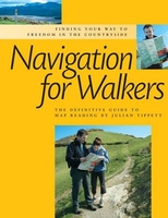
Navigation For Walkers

”Navigation for Walkers” has established itself as the leading authority on map reading for those taking up outdoor pursuits in the UK. It is a tried and tested book which was the first to cover this important skill. This 2nd edition has been updated to include a chapter on digital navigation, has an improved hill navigation section and uses references to current mapping appropriate to outdoor pursuits. Only with a good understanding of maps can anybody truly experience the freedom of walking centuries old paths, bridleways and green lanes which make up the thousands of miles of public rights of way that criss-cross often remote open countryside - a copy of Navigation for Walkers in a rucksack will be worth its weight in gold. Aimed at the beginner and those looking to refresh their
knowledge, the author`s technique of using his photographs to graphically link the features on the ground to those on the map makes learning easy and fun.
RIP - This product is no longer available on our network. It was last seen on 25.09.2019

This page now acts as a permanent archive for this product. Add more information using the comments box below to ensure it can still be found by future generations.

Use our search facility to see if it is available from an alternative contributor.
  • External links may include paid for promotion
  • Availability: Out Of Stock
  • Supplier: Stanfords
  • SKU: 9781904207627
Availability: In Stock
£10.99

Product Description

” Navigation for Walkers” has established itself as the leading authority on map reading for those taking up outdoor pursuits in the UK. It is a tried & tested book which was the first to cover this important skill. This 2nd edition has been updated to include a chapter on digital navigation, has an enhanced hill navigation section & uses references to current mapping appropriate to outdoor pursuits. Only with a good understanding of maps can anybody truly experience the freedom of walking centuries old paths, bridleways & green lanes which make up the thousands of miles of public rights of way that criss-cross often remote open countryside
- a copy of Navigation for Walkers in a rucksack will be worth its weight in gold. Aimed at the beginner & those looking to refresh their knowledge, the author`s technique of using his photographs to graphically link the features on the ground to those on the map makes learning easy & fun.

Reviews/Comments

Add New

Intelligent Comparison

Oooops!
We couldn't find anything!
Perhaps this product's unique.... Or perhaps we are still looking for comparisons!
Click to bump this page and we'll hurry up.

Price History

Vouchers

No voucher codes found.
Do you know a voucher code for this product or supplier? Add it to Insights for others to use.

Facebook

Jargon Buster

Gold - A precious highly conductive metal
UK - United Kingdom - An island nation in Europe
Digital - A system that uses only 0s and 1s to transmit data
Fun - Something that provides amusement or enterainment
weight - A measure of the force applied on an object by gravity. Measured metric in grams and kilos or imperial in lbs and oz
Weight - a measurement of how heavy an object appears due to the pull of gravity. For example the weight of an object on planet earth will be different to the weight of the object on the moon
Gold - A colour, a type of rich metal. Chemical symbol AU.
Rucksack - A bag which is carried on the back.
Learning - Educating and growing in intelligence.
Experience - To gain further knowledge by practising.

Supplier Information

Stanfords
Stanfords was established in 1853 and opened their iconic Covent Garden flagship store in 1901. They have become the top retailer of maps, travel books and accessories in the UK and arguably offer the largest selection of maps and travel books worldwide. Famous names such as Captain Robert Falcon Scott, Ranulph Fiennes and Michael Palin have purchased from Stanfords. They now have a shop in Bristol and both stores together with other venues operate a calendar of events including talks, book signings and exhibitions. As a specialist map retailer, the map selection is comprehensive and includes road maps, street maps and walking maps from worldwide destinations, as well as a selection of world atlases and wall maps. Books include travel guides and travel literature. Stanfords also stock globes, from miniatures made of blue marble to magnificent floor-standing globes. The website features a selection of interesting articles on travel topics.
Page Updated: 2023-11-12 20:15:36

Community Generated Product Tags

Oh No! The productWIKI community hasn't generated any tags for this product yet!
Menu