More From Contributor

£14.95
Part of a series of books from Anavasi publishing showing certain Greek Islands from an angle rarely seen by the human eye
- from
...
Archived Product
£7.99
Naxos on light, a waterproof & tear-resistant, contoured & GPS compatible map at 1:40, 000 from Anavasi, highlighting 10 recommended hiking trails, plus on the reverse coverage of six smaller nearby islands in the Cyclades: Donoussa, Irakleia, Schoinousa / Schinousa, Upper & Lower Koufonisi, plus Keros. On one side is the map of Naxos. Landscape is vividly shown by contours at 20m with altitude colouring, hill shading & spot heights, plus graphics to show various types of vegetation: woodlands, olive groves, vineyards, etc. The map indicates dirt roads in poor condition & difficult tracks, with distances marked on many local routes, plus locations of petrol stations. Country paths distinguish between wide & well defined or narrow and/or poorly defined routes. 10 hiking trails, from 2km to 11.5km long, are highlighted & symbols show places of interest including beaches, archaeological sites, etc. All place names are in both Greek & Latin alphabets. The map has a 1km UTM grid plus latitude/longitude margin ticks & crosshairs at 1’. On the reverse the six nearby smaller islands are presented at 1:25, 000. Six hiking routes are highlighted: two on Irakleia, plus one on Schoinousa, Upper Koufonisi, Lower Koufonisi & Donoussa. Map legend & all the text include English. To see which other Greek islands are covered by maps from Anavasi, please click on the series link. ...
Archived Product
£9.95
Naxos & the Lesser Cyclades in the Mc Gilchrist’s Greek Islands series focuses primarily on cultural tourism for the visitor who wishes to understand more about the art, history & architecture of the islands. The series contains no photographs, but has specially drawn maps for each island (66 in total) & site plans for every major site (57 in total), together with thoroughly comprehensive textual information. Each guide also recommends a small number of places to stay & eat selected for their simplicity & unpretentiousness. ...
Archived Product
£9.99
Naxos at 1:40, 000 on a contoured, GPS compatible hiking map published by Terrain Cartography group together with Skai Maps, & printed on light, waterproof & tear-resistant Polyart plastic paper, with extensive tourist information. Topography is very well presented by contours, enhanced by spot heights, subtle relief shading & additional altitude colouring. Contour interval, unless indicated below to the contrary, is 20m. National parks & other protected areas are marked. All place names are shown in both Greek & Latin alphabet. The maps have a UTM grid, plus latitude & longitude margin ticks. Hiking trails are graded between main routes & narrow trails. A wide range of symbols indicate various places of interest & recreational facilities, with main sights clearly highlighted. Most titles distinguish between sandy & pebble beaches; some also indicate beaches with natural shade and/or the type of sea bed. Road network is very clearly graded according to width & the type of surface, distinguishing between good & rough dirt roads. Distances are marked on most small local roads, as well as locations of petrol stations and/or tyre repair workshops. Scenic routes are highlighted. Each map also shows which ports are served by ferry services. Many titles include a street plan of the island’s main town, with colouring clearly showing various tourist facilities. The reverse side of each title is covered by general information about the isl&, illustrated with colour photos. Many titles also include brief descriptions of recommended hiking trails.* Map legend & all the text include English.** In this title:* street plan of the Hora of Naxos, descriptions of 12 selected hiking trails. ...
Archived Product
£1.99
In this booklet Jill Dudley describes how, after he killed he Minotaur, Theseus came to Naxos with Ariadne & lived on the small offshore islet of Palatia now dominated by the great marble Portara (gateway). She explains how Dionysos, god of wine & drama came to Naxos & claimed the island as his own, & how tradition has it the supreme god Zeus grew up in a cave on Naxos. It is as the back cover of the booklet says: all you need to know about the island`s myths, legends & its gods. ...
Archived Product
£8.95
Burma’s new & old capital cities, Nay Pyi Taw & Yangon (Rangoon) on map from the Odyssey Books, presenting each city on one side of the map on a street plan showing important buildings, hotels, etc, with the surrounding panels & photos, cross-referenced to the plan, providing more tourist information. On one side is a street plan of Yangon at 1:25, 700, highlighting main traffic arteries & naming selected other streets. The city centre is also presented in more detail on a separate inset. Various places of interest are highlighted, including hotels, temples & pagodas, etc. Locations of 37 sights, specially selected for their rich architectural & historical heritage, are highlighted on the plan & cross-referenced to descriptions surrounding the plan. Many are also illustrated with colour photos. On the reverse is a street plan at 1:60, 000 of Myanmar’s new capital city, Nay Pyi Taw, with locations of government institutions & various other places of interest. 22 sites or buildings are cross-referenced to the accompanying descriptions & photos. ...
Archived Product
£8.95
This is a folded, card covered map which is double sided (folded 250mm x 120mm, flat 990mm x 680mm) with 1:60, 000 & 1:3, 200, 000 map scales of Myanmar`s new administrative capital city Nay Pyi Taw & of the whole country. The map is also an information sheet, heavily illustrated with colour photographs & paragraphs of text describing key areas of the city & Myanmar (also known as Burma). The map is full of information to help travellers & business visitors understand Myanmar`s new city & get the most out of a visit. ...
Archived Product
£17.95
Routes from Kathmandu to the Langtang Valley, with an enlargement for the Naya Kanga massif, in the Nepa Maps series which provides extensive coverage of trekking areas of Nepal on detailed contoured maps with trekking routes & hiking trails, huts & camp sites, local places of interest & other tourist information. Cartography is based on the country’s topographic survey, with contours usually at 40m or 50m intervals, enhanced by relief shading, colouring & graphics to show various features of the terrain, including glaciers, forested or cultivated areas, etc. Numerous peaks, with additional spot heights, plus names of glaciers & mountain ranges are prominently shown. The network of rivers, streams & lakes is shown in great detail, with many smaller rivers & lakes named. Overprint highlights main trekking routes & numerous local trails, with symbols indicating various places of interest & tourist facilities. Most maps are indexed & include additional information such as route profiles, glossaries, etc. All the information is in English & heights are given in metres.* In this title:* the area between the outskirts of Kathmandu & the Langtang Valley, with Kangja La pass, Naya Kanga & the Shivapuri Watershed & Wildlife Reserve. Contours are at 125m intervals, with relief shading & vegetation colouring. Index lists places, peaks, lakes & passes. Margin ticks show latitude & longitude at intervals of 5’. Additional information

Includes::
an inset showing the Naya Kanga massif at 1:80, 000 with the route to the summit from the Langtang Valley, a profile of the route from Melamchi Bazar to Naya Kanga, plus tables showing the routes in stages with altitudes in metres & feet & trekking times.

...
Archived Product
£12.99
One of the titles in a series of road maps of the administrative states of Mexico, highlighting places of interest. The maps show four different grades of roads, with intermediate driving distances on main routes, railways, local airports, ferry connections & administrative boundaries. Topographic information is limited to names of main mountain ranges, spot heights for main peaks, rivers & lakes. The maps have no geographical coordinates. Map legend is in Spanish only. On the reverse each title has a black & white version of the same map, highlighting places of interest with brief notes in Spanish only. ...
Archived Product
£13.99
Road maps of Mexico’s states from Ediciones Independencia highlighting numerous places of interest & tourist facilities, with each title also providing a large street plan of the provincial capital plus maps of other local towns, popular tourist resorts and/or archaeological sites. The state maps show the road & rail networks on a clear base, with topography indicated by rivers & areas liable to inundation, plus names of main mountain ranges & peaks (no heights). National parks & other protected areas are brightly highlighted. A range of symbols provides information for tourists: accommodation including campsites & trailer parks, historical & archaeological sites, beaches & spas, sport & leisure centres, natural curiosities, etc. The maps show latitude & longitude as margin ticks & crosshairs, mostly at 30’ or 1° intervals. Map legend

Includes::
English. Most maps have no index. Each title

Includes::
a large street plan of the provincial capital, plus plans of selected other towns. In addition to street names, the plans also show names of local districts. Plans of the state capital usually have a list of various locations, facilities and/or places on interest highlighted on it, & some include an enlargement showing the town centre in greater detail. Each title also has a table of distances, plus a table showing various facilities & places of interest in the main towns of the state.


...
Archived Product

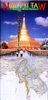
Nay Pyi Taw & Myanmar (Burma) Odyssey Map & Booklet Pack

Nay Pyi Taw, Burma’s new capital, in a set which combines a 79-page glossy guide to the city and its environs with a street plan of city and a map of the whole country. The map has on one side a street plan at 1:60, 000 of Nay Pyi Taw, extending from its international airport in the south to the Pobbathiri district in the north. Numerous hotels, various facilities and other important buildings are marked and the State Guest-Houses area is also shown in greater detail on a separate inset. 23 locations are highlighted on the plan and accompanied by descriptions placed around the plan and illustrated with colour photos.On the reverse are two road maps. Burma is covered at 1:3, 200, 000 on a map with the country’s road and rail networks presented on a physical base showing the
country’s topography. Various places of interest are highlighted and accompanied by descriptions which also include notes on the country’s fauna and flora, handicrafts, etc. Another panel presents “Myanmar in a Modern Regional Context” – a map of southern Asia at 1:15, 000, 000, surrounded by boxes with facts and figures about all the countries in the region. The 79-page booklet has notes about the city and its sites and facilities (including a list of hotels with contact details), suggestions for out-of-town excursions, notes about the country and its history, etc. The booklet is illustrated with numerous colour photos.
RIP - This product is no longer available on our network. It was last seen on 25.09.2019

This page now acts as a permanent archive for this product. Add more information using the comments box below to ensure it can still be found by future generations.

Use our search facility to see if it is available from an alternative contributor.
  • External links may include paid for promotion
  • Availability: Out Of Stock
  • Supplier: Stanfords
  • SKU: 9789622178632
Availability: In Stock
£14.95

Product Description

Nay Pyi Taw, Burma’s new capital, in a set which combines a 79-page glossy guide to the city & its environs with a street plan of city & a map of the whole country. The map has on one side a street plan at 1:60, 000 of Nay Pyi Taw, extending from its international airport in the south to the Pobbathiri district in the north. Numerous hotels, various facilities & other important buildings are marked & the State Guest-Houses area is also shown in greater detail on a separate inset. 23 locations are highlighted on the plan & accompanied by descriptions placed around the plan & illustrated with colour photos. On the reverse are two road maps. Burma is covered at 1:3, 200, 000 on a map with the country’s road & rail networks presented on a physical base showing the country’s topography. Various places of interest are highlighted & accompanied by descriptions which also include notes on the country’s fauna & flora, handicrafts, etc. Another panel presents “ Myanmar in a Modern Regional Context” – a map of southern Asia at 1:15, 000, 000, surrounded by boxes with facts & figures about all the countries in the region. The 79-page booklet has notes about the city & its sites & facilities (including a list of hotels with contact details), suggestions for out-of-town excursions, notes about the country & its history, etc. The booklet is illustrated with numerous colour photos.

Reviews/Comments

Add New

Intelligent Comparison

Oooops!
We couldn't find anything!
Perhaps this product's unique.... Or perhaps we are still looking for comparisons!
Click to bump this page and we'll hurry up.

Price History

Vouchers

No voucher codes found.
Do you know a voucher code for this product or supplier? Add it to Insights for others to use.

Facebook

Jargon Buster

Physical - Used to describe strength or visual properties of an item
History - Anything that happens in the past. An acedemic subject.
Colour - The categorised spectrum of light visable to humans
Set - a group of items usually related to one another. Some objects cannot function without the complete set of items.
Road - a manmade lane or a path that is used to speed up travel.
Regional - An adjective to describe a set geographic area.
Glossy - Something that is smooth and shiny in appearance.

Supplier Information

Stanfords
Stanfords was established in 1853 and opened their iconic Covent Garden flagship store in 1901. They have become the top retailer of maps, travel books and accessories in the UK and arguably offer the largest selection of maps and travel books worldwide. Famous names such as Captain Robert Falcon Scott, Ranulph Fiennes and Michael Palin have purchased from Stanfords. They now have a shop in Bristol and both stores together with other venues operate a calendar of events including talks, book signings and exhibitions. As a specialist map retailer, the map selection is comprehensive and includes road maps, street maps and walking maps from worldwide destinations, as well as a selection of world atlases and wall maps. Books include travel guides and travel literature. Stanfords also stock globes, from miniatures made of blue marble to magnificent floor-standing globes. The website features a selection of interesting articles on travel topics.
Page Updated: 2023-11-12 20:15:36

Community Generated Product Tags

Oh No! The productWIKI community hasn't generated any tags for this product yet!
Menu