
 United Kingdom
 France
 Germany
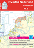
 Netherlands
 Sweden
 USA
USA
 Italy
Italy
 Spain
Spain
More From Contributor


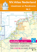
NL3 Ijsselmeer En Randmeren
Passage ChartsC1 Rotterdam tot IJsselmeer 1:375.000 Coastal ChartsC2 IJsselmeer Noord 1:80.000 C3 IJsselmeer Zuid 1:80.000 C4 Markermeer 1:80.000 C8A Gouwzee 1:30.000 C10 Friese Meren Oost 1:50.000 C11 Friese Meren West 1:50.000 C14 Randmeren· Gooimeer· Eemmeer 1:50.000 C15 Randmeren · Wolderwijd 1:50.000 C16 Randmeren · Veluwemeer 1:50.000 C17 Randmeren · Elburg · Ketelbrug 1:50.000 C18 Overijssel · Zwarte Meer · Zwolle 1:50.000 DetailsC5A Kornwerderzand · Makkum 1:20.000 C5B Den Oever 1:20.000 C5C Stavoren 1:20.000 C6A Enkhuizen 1:15.000 C6B Breezanddijk 1:15.000 C6C Medemblik 1:15.000 C6D Hindeloopen 1:20.000 C7A Lemmer 1:15.000 C7B Lelystad 1:20.000 C8B Edam 1:5.000 C8C Haven Volendam 1:5.000 C8D Marina Volendam 1:5.000 C8E Andijk 1:10.000 C8F Uitdam 1:5.000 C8G Marken 1:5.000
C9A Hollandse Brug 1:5.000 C9B Durgerdam 1:5.000 C9C Hoorn 1:10.000 C9D Monnickendam 1:5.000 C11A Sneekermeer · Sneek 1:30.000 C11B Heeg 1:30.000 C11C Langweer 1:30.000 C12 Amsterdam Havens West 1:20.000 C13 Amsterdam Havens Oost 1:20.000 C15A Harderwijk 1:15.000 C17A Ketelmeer 1:30.000 C19A Roggebotsluis 1:15.000 C19B Eemmond 1:15.000 C19C Zwartsluis 1:15.000 C19D Bremerbergse Hoek 1:15.000 C19E Nijkerk 1:15.000 C19F Hasselt 1:15.000 C19G Zeewolde 1:15.000 C19H Huizen 1:15.000 C19J Spakenburg 1:15.000 C20A Urk 1:10.000 C20B Kampen 1:15.000 C20C Elburg 1:15.000 C20D Almere Haven 1:15.000 C20E Nulde 1:10.000 C20F Genemuiden 1:10.000 C20G Muiden 1:10.000
C9A Hollandse Brug 1:5.000 C9B Durgerdam 1:5.000 C9C Hoorn 1:10.000 C9D Monnickendam 1:5.000 C11A Sneekermeer · Sneek 1:30.000 C11B Heeg 1:30.000 C11C Langweer 1:30.000 C12 Amsterdam Havens West 1:20.000 C13 Amsterdam Havens Oost 1:20.000 C15A Harderwijk 1:15.000 C17A Ketelmeer 1:30.000 C19A Roggebotsluis 1:15.000 C19B Eemmond 1:15.000 C19C Zwartsluis 1:15.000 C19D Bremerbergse Hoek 1:15.000 C19E Nijkerk 1:15.000 C19F Hasselt 1:15.000 C19G Zeewolde 1:15.000 C19H Huizen 1:15.000 C19J Spakenburg 1:15.000 C20A Urk 1:10.000 C20B Kampen 1:15.000 C20C Elburg 1:15.000 C20D Almere Haven 1:15.000 C20E Nulde 1:10.000 C20F Genemuiden 1:10.000 C20G Muiden 1:10.000

Product Description
Reviews/Comments
Add New
Vouchers
No voucher codes found.
Do you know a voucher code for this product or supplier? Add it to Insights for others to use.
Do you know a voucher code for this product or supplier? Add it to Insights for others to use.
 Denmark