More From Contributor
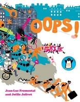
£10.99
Lightweight, convenient & durable, Onya Side bags are the perfect way to kick your plastic shopping bag habit. made from a tough but thin synthetic fabric with their own built-in carry-pouch, these bags pack away so small they can easily be carried in a bag or even pocket. When you need them, they expand out to a large satchel/ ...
Archived Product
£16.99
Begin with Noodle Basics where you`ll find detailed information on the different types of noodles, flavours & fresh or store-cupboard ingredients that are found in the very best of noodle recipes, alongside basic recipes for oils, stocks, dressings, toppings, dipping sauces & more from all over Asia. The recipes take inspiration from many countries, including Japanese Chilled Soba Noodles & Salmon & Spring Onion Gyoza, Vietnamese Beef Pho & Green Papaya & Crispy Pork Salad, traditional Crispy Prawn Balls from China, Singapore Hokkein Noodles & Korean Noodle Dumplings, as well as recipes from Burma, Malaysia, Cambodia & Laos. Fresh, tasty & bursting with nutritious ingredients & lively flavours, noodle dishes have never been more popular. Learn how to cook, serve & eat them following Louise`s straightforward recipes that give thoughtful insight into the provenance of each dish. This collection of aromatic & sizzling hot recipes is a must for any lover of more exotic & adventurous food. ...
Archived Product
£14.99
Oodnadatta to Alice Springs route in a series of spiral-bound atlases from Design Interaction showing routes across Australia’s Northern Territory with GPS coordinates & accompanied by information about local facilities, useful tips & colour photos. The atlas has a latitude & longitude grid at intervals of 5’. Each atlas in this series presents the route on a plain base with colouring showing national parks/protected areas & Aboriginal lands. Topographic information is limited to rivers, creeks or lakes along the route or in its immediate vicinity. Along the route a wide range of symbols indicates various facilities including accommodation, food & fuel supplies, mechanical & tyre repair, emergency services, places of interest, etc. Driving distances are shown at regular intervals & annotations provide tips about entry permits & fees, danger points, communication with emergency services, etc. Each route is shown in stages & accompanied by colour photos of interesting landscape features & other various points along it. Each page of the atlas has a latitude & longitude grid & various places along the route itself are annotated with GPS waypoints. Also provided is a list of useful addresses. ...
Archived Product
£6.99
Berets, baguettes & strings of onions are all very well, but to really fit in across the Channel takes a certain...je ne sais quoi. The French might make it look easy, but being French requires a fine balance of aloof confidence, an innate sense of superiority, joie de vivre & doing everything with style. Then, of course, there are the basics to get to grips with, such as the fact that the customer is always wrong, why it`s OK to let your dog do its business in the street, why queuing is not necessary & why French cuisine is undeniably the best in the entire world. This witty book takes a humorous look at the charms & foibles of the Gallic nation, teaching you everything you need to know about being correctly French, including such essentials as: how to perfect the Gallic shrug; the real French rules of the road; &, how & when to stage a strike/demonstration. ...
Archived Product
£11.99
Topographical survey of Belgium at 1:50, 000 from the country’s national survey organization, Nationaal Geografisch Instituut / Institut Géographique National. Contour interval varies according to the terrain, from 2.5 metres in the coastal areas to 10 metres in the Ardennes. The maps provide all the information expected of topographic mapping at this scale & in addition have an unusually large amount of vegetation and/or land use information (different types of woodlands, gardens, orchards, heath, etc). Each standard sheet covers Approx. 32 x 20 km / 20 x 12 miles, with larger maps published for the border or coastal areas. The maps have a 1-km UTM grid, with margin ticks for latitude & longitude at intervals of 1`. Map legend & a glossary of terms used on the maps include English.PLEASE NOTE: the Long-Distance Footpaths Map of Belgium at 1:300, 000 is overprinted with the grid for the 1:50, 000 topographic survey, showing the exact coverage of each sheet. Stanfords keeps as regular stock 50K maps for the World War I battlefields around the Ypres, Messines & Passchendaele, & for the area of the Battle of Waterloo. Maps for other regions can be supplied as special orders – to see the list of all the titles in this series please click on the series link. ...
Archived Product
£17.99
Kadaster, Holland`s national survey organization, produces one of the most attractive topographic surveys in Europe. The maps are very colourful, with their characteristic patchwork of polders & an unusually large amount of land use information: meadows, arable l&, different types of forest, marshes, sand dunes, etc. Contours are shown at 5-metre intervals with numerous spot heights &, with such a large part of the country below the sea level, ”spot depths”. Each map covers an area of Approx. 25 x 20 km / 15 x 12 miles, with some sheets slightly larger. The maps have a 1-km Dutch national grid, plus latitude & longitude at intervals of 1`. Map legend

Includes::
English.IMPORTANT
- PLEASE NOTE BEFORE ORDERING: both the west (W) & the east (O) sheet of each number has the same name, although the town after which the two maps are named appears only on one of the sheets. For example: maps 41W & 41O are both called Arnhem, although the city of Arnhem appears only on sheet 40W, etc. To see the list of titles available in this series please click on the series link.


...
Archived Product
£9.50
Topographical survey of Belgium at 1:20, 000 from Nationaal Geografisch Instituut / Institut Géographique National, the country’s national survey organization. Each 20K map covers one quarter of the corresponding 1:50, 000 map (with adjustments in the border & coastal areas). The maps provide all the information expected of topographic mapping at this scale & in addition have an unusually large amount of vegetation and/or land use information (different types of woodlands, gardens, orchards, heath, etc). The maps have a 1-km UTM grid, with margin ticks for latitude & longitude at intervals of 1`. Map legend & a glossary of terms used on the maps include English. Stanfords keeps as regular stock 20K maps for the World War I battlefields around the Ypres, Messines & Passchendaele, & for the area of the Battle of Waterloo. The 1:20, 000 survey covers the whole of Belgium & maps for other regions can be supplied as special orders. To see the list of titles in this series please click on the series link.PLEASE NOTE: the Long-Distance Footpaths Map of Belgium at 1:300, 000 which shows the division of Belgium into the 50K survey sheets can also be used to see in more detail coverage by the 20K maps. ...
Archived Product
£8.99
Oostvaardersplassen area of the Netherlands in a series of walking & cycling maps at 1:25, 000 – 1:35, 000, published by Falk BV in cooperation with Staatsbosbeheer – Dutch government’s organization for forestry & the management of nature reserves. Colouring indicates different types of vegetation or terrain: woodl&, pastures, heath or sand dunes. Given the topography of most of the country, the maps have no contour lines. The maps show local hiking trails, indicating their waymarking & include cycle paths & horse riding. Many local crossroads are annotated with the numbers of ANWB signposts & ‘mushrooms’ – a useful aid when navigating in Dutch countryside. Symbols indicate various tourist facilities & places of interest, including different types of accommodation, cafes, windmills, etc. The maps have no geographical coordinates. Map legend is in Dutch only. On the reverse each title has supplementary information, in Dutch only, about the region`s attractions. To see other titles in this series please click on the series link. ...
Archived Product

Oops!

Illustrated with Joelle Jolivet`s retro, eye-catching style, ”Oops” follows a family through the streets of Paris as they try to get to the airport for their vacation. Back at their apartment, their house-sitting aunt slips on some soap, and this sets off a chain reaction of events that create some extreme roadblocks for the family`s trip. A movie shoot, a parade, policemen, aliens and much more collide in this remarkable new picture book adventure. It includes a gatefold page at the end that explains the chaos of the previous pages.
RIP - This product is no longer available on our network. It was last seen on 25.09.2019

This page now acts as a permanent archive for this product. Add more information using the comments box below to ensure it can still be found by future generations.

Use our search facility to see if it is available from an alternative contributor.
  • Availability: Out Of Stock
  • Supplier: Stanfords
  • SKU: 9780810987494
Availability: In Stock
£10.99

Product Description

Illustrated with Joelle Jolivet`s retro, eye-catching style, ” Oops” follows a family through the streets of Paris as they try to get to the airport for their vacation. Back at their apartment, their house-sitting aunt slips on some soap, & this sets off a chain reaction of events that create some extreme roadblocks for the family`s trip. A movie shoot, a parade, policemen, aliens & much more collide in this remarkable new picture book adventure. It

Includes::
a gatefold page at the end that explains the chaos of the previous pages.

Reviews/Comments

Add New

Intelligent Comparison

Oooops!
We couldn't find anything!
Perhaps this product's unique.... Or perhaps we are still looking for comparisons!
Click to bump this page and we'll hurry up.

Price History

Vouchers

No voucher codes found.
Do you know a voucher code for this product or supplier? Add it to Insights for others to use.

Facebook

Jargon Buster

Eye - An organ which detects light
soap - The salt of a fatty acid used for cleaning and as a component of lubricants.
Adventure - an undertaking of an exciting challenge or experience.
Retro - something that is vintage or replicates a style in the past.
Family - A group of people that live together made up from parents and children.

Supplier Information

Stanfords
Stanfords was established in 1853 and opened their iconic Covent Garden flagship store in 1901. They have become the top retailer of maps, travel books and accessories in the UK and arguably offer the largest selection of maps and travel books worldwide. Famous names such as Captain Robert Falcon Scott, Ranulph Fiennes and Michael Palin have purchased from Stanfords. They now have a shop in Bristol and both stores together with other venues operate a calendar of events including talks, book signings and exhibitions. As a specialist map retailer, the map selection is comprehensive and includes road maps, street maps and walking maps from worldwide destinations, as well as a selection of world atlases and wall maps. Books include travel guides and travel literature. Stanfords also stock globes, from miniatures made of blue marble to magnificent floor-standing globes. The website features a selection of interesting articles on travel topics.
Page Updated: 2023-11-12 20:15:36

Community Generated Product Tags

Oh No! The productWIKI community hasn't generated any tags for this product yet!
Menu